Troy, New Hampshire facts for kids
Quick facts for kids
Troy, New Hampshire
|
|
|---|---|
|
Town
|
|
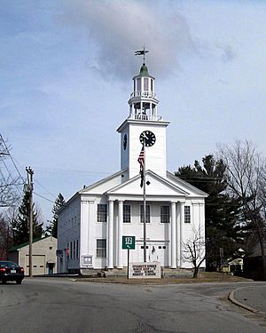
Town Hall
|
|
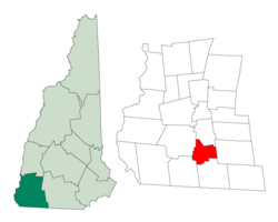
Location in Cheshire County, New Hampshire
|
|
| Country | United States |
| State | New Hampshire |
| County | Cheshire |
| Incorporated | 1815 |
| Villages |
|
| Area | |
| • Total | 17.6 sq mi (45.6 km2) |
| • Land | 17.5 sq mi (45.2 km2) |
| • Water | 0.2 sq mi (0.4 km2) 0.89% |
| Elevation | 1,010 ft (310 m) |
| Population
(2020)
|
|
| • Total | 2,130 |
| • Density | 122/sq mi (47.1/km2) |
| Time zone | UTC-5 (Eastern) |
| • Summer (DST) | UTC-4 (Eastern) |
| ZIP code |
03465
|
| Area code(s) | 603 |
| FIPS code | 33-77380 |
| GNIS feature ID | 0873740 |
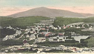
Troy is a town in Cheshire County, New Hampshire, United States. In 2020, about 2,130 people lived there. It is located in the southwestern part of New Hampshire, west of Mount Monadnock.
The main part of Troy is called the Troy census-designated place (CDP). In 2020, 1,108 people lived in this central village. It is located along New Hampshire Route 12. The center of the CDP is recognized as the Troy Village Historic District on the National Register of Historic Places.
Contents
History of Troy
Troy was first settled in 1762. By 1815, the community had grown quite a bit. It wanted to become its own official town. That year, it separated from Marlborough. It also included parts of Fitzwilliam, Swanzey, and Richmond.
Captain Benjamin Mann, a well-known citizen and friend of Governor John Taylor Gilman, suggested the name "Troy". His daughter, Betsy, was married to Samuel Wilson. Samuel Wilson is famous as "Uncle Sam". At that time, he lived in Troy, New York. At least seven members of Wilson's family were living in the town when it was named. The town hall, built in 1813–1814, was originally the village meetinghouse. It is located near the common land.
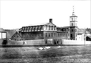
The Troy Mills company was very important to the town's economy for almost 100 years. It started making horse blankets in the mid-1800s. In 1865, the founder, Thomas Goodall, sold the company. He later started Goodall Mills in Sanford, Maine in 1867.
Troy Mills closed down in 2002 after declaring bankruptcy in late 2001. After that, two smaller companies, Knowlton Nonwovens and Cosmopolitan Textiles, operated in the large mill building for several years. Today, the "Troy" name is used for felt made by a company in West Virginia. In the past, Troy also produced wooden items, pottery, and fine building stone. As of 2024, the old Troy Mills building is being made into affordable apartments for families.
Geography and Location
According to the United States Census Bureau, Troy covers a total area of 45.6 square kilometers (17.6 square miles). Of this, 45.2 square kilometers (17.5 square miles) is land, and 0.4 square kilometers (0.2 square miles) is water. Water makes up about 0.89% of the town's total area.
The South Branch of the Ashuelot River flows through Troy. This river system is part of the larger Connecticut River watershed.
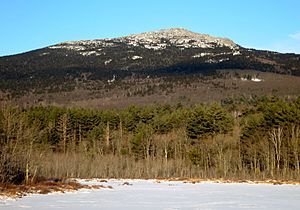
The highest point in Troy is the south summit of Gap Mountain. It is about 1,900 feet (579 meters) above sea level. This point is near the town's eastern border. The very top of Mount Monadnock is about 2 miles (3 kilometers) northeast of Troy, in Jaffrey.
Troy is crossed by two main roads: New Hampshire Route 12 and New Hampshire Route 124.
- NH 12 goes through the center of town. It leads northwest about 9 miles (14 km) to Keene. It also goes southeast about 12 miles (19 km) to Winchendon, Massachusetts.
- NH 124 crosses the northeastern part of Troy. It leads northwest about 6 miles (10 km) to the center of Marlborough. It also goes east about 6 miles (10 km) to the center of Jaffrey.
Neighboring Towns
Troy shares borders with these towns:
- Marlborough (to the north)
- Jaffrey (to the east)
- Fitzwilliam (to the south)
- Richmond (to the southwest)
- Swanzey (to the west)
Population and People
| Historical population | |||
|---|---|---|---|
| Census | Pop. | %± | |
| 1820 | 676 | — | |
| 1830 | 676 | 0.0% | |
| 1840 | 683 | 1.0% | |
| 1850 | 759 | 11.1% | |
| 1860 | 761 | 0.3% | |
| 1870 | 767 | 0.8% | |
| 1880 | 796 | 3.8% | |
| 1890 | 999 | 25.5% | |
| 1900 | 1,527 | 52.9% | |
| 1910 | 1,331 | −12.8% | |
| 1920 | 1,444 | 8.5% | |
| 1930 | 1,267 | −12.3% | |
| 1940 | 1,321 | 4.3% | |
| 1950 | 1,360 | 3.0% | |
| 1960 | 1,445 | 6.3% | |
| 1970 | 1,713 | 18.5% | |
| 1980 | 2,131 | 24.4% | |
| 1990 | 2,097 | −1.6% | |
| 2000 | 1,962 | −6.4% | |
| 2010 | 2,145 | 9.3% | |
| 2020 | 2,130 | −0.7% | |
| U.S. Decennial Census | |||
In 2010, the census showed that 2,145 people lived in Troy. There were 867 households and 568 families. The town had about 123 people per square mile (47 people per square kilometer). There were 932 homes, with about 53 homes per square mile (20 homes per square kilometer).
Most of the people in Troy were White (97.0%). Other groups included African American (0.8%), Native American (0.7%), and Asian (0.9%). About 1.3% of the population was Hispanic or Latino.
In 2010, 31.5% of households had children under 18 living with them. About 49.3% of households were married couples living together. About 11.2% had a female head of household with no husband present. And 34.5% were not families. About 26.2% of all households were made up of single individuals. About 7.6% were people living alone who were 65 years old or older. The average household had 2.47 people, and the average family had 2.96 people.
The population's age spread in Troy was:
- 23.1% were under 18 years old.
- 8.1% were from 18 to 24 years old.
- 28.5% were from 25 to 44 years old.
- 29.0% were from 45 to 64 years old.
- 11.5% were 65 years old or older.
The average age was 37.8 years. For every 100 females, there were 99.7 males. For every 100 females aged 18 and over, there were 97.8 males.
From 2010 to 2014, the average yearly income for a household in Troy was estimated to be $55,043. For a family, the average income was $59,750. Men working full-time had an average income of $45,800, while women had an average income of $28,359. The average income per person in the town was $29,045. About 4.9% of families and 8.5% of the total population lived below the poverty line. This included 12.6% of those under 18 and 17.3% of those aged 65 or older.
Education in Troy
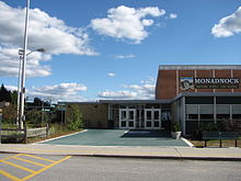
Students in Troy attend public schools that are part of the Monadnock Regional School District (SAU93).
- Children in kindergarten through sixth grade go to Troy Elementary School.
- Students from seventh grade onwards attend Monadnock Regional High School.
Troy is the second largest town in the Monadnock Regional School District. The largest town is Swanzey. Other towns in this school district include Fitzwilliam, Gilsum, Richmond, and Roxbury.
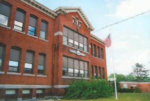
Troy Elementary School is located in Troy. The middle and high school is located north of Troy, in the town of Swanzey. Troy School has been educating children since 1895. It was built to hold 225 students of all ages. Today, Troy School teaches about 135 students in grades K–6. The school day starts at 8:30 AM and ends at 3:10 PM. Students can enter the building at 8:15 AM to have breakfast and get ready for class.
Troy also has two child care centers that were licensed in 2015. These centers can care for up to 75 children.
Notable Person
- Ira Allen Eastman (1809–1881) was a member of the House of Representatives.
See also
 In Spanish: Troy (Nuevo Hampshire) para niños
 | Roy Wilkins |
 | John Lewis |
 | Linda Carol Brown |


