
Marlborough, New Hampshire facts for kids
Quick facts for kids
Marlborough, New Hampshire
|
||
|---|---|---|
|
Town
|
||

Main Street in 1910
|
||
|
||
| Motto(s):
"Small Town - Big Heart"
|
||

Location in Cheshire County, New Hampshire
|
||
| Country | United States | |
| State | New Hampshire | |
| County | Cheshire | |
| Incorporated | 1776 | |
| Area | ||
| • Total | 20.7 sq mi (53.5 km2) | |
| • Land | 20.4 sq mi (52.9 km2) | |
| • Water | 0.2 sq mi (0.6 km2) 1.13% | |
| Elevation | 705 ft (215 m) | |
| Population
(2020)
|
||
| • Total | 2,096 | |
| • Density | 103/sq mi (39.6/km2) | |
| Time zone | UTC-5 (Eastern) | |
| • Summer (DST) | UTC-4 (Eastern) | |
| ZIP code |
03455
|
|
| Area code(s) | 603 | |
| FIPS code | 33-45460 | |
| GNIS feature ID | 0873659 | |

Marlborough is a town located in Cheshire County, New Hampshire, United States. In 2020, about 2,096 people lived here. It is known for the Kensan-Devan Wildlife Sanctuary at Meetinghouse Pond, a special place for nature.
The main part of town, where most people live, is called the Marlborough census-designated place (CDP). This area is found where New Hampshire routes 101 and 124 meet.
Contents
History of Marlborough
Marlborough was first given a name in 1752 by Governor Benning Wentworth. It was called "Monadnock No. 5" back then. It was one of several "fort towns" that were just known by a number.
People started settling here in 1764. The town was once called "Oxford" and then "New Marlborough." But in 1776, it officially became "Marlborough." Many of the first settlers came from a town called Marlborough, Massachusetts. That town was named after John Churchill, 1st Duke of Marlborough, a famous person from the late 1600s.
In 1815, some of Marlborough's land was used to create the nearby town of Troy.
Marlborough was once famous for its granite industry. Stone from the town's quarries was used to build structures in places like Boston and at the College of the Holy Cross in Worcester, Massachusetts. It was also used locally in the Frost Free Library. Besides stone, Marlborough also made blankets and wooden items, including toys.
Geography of Marlborough
Marlborough covers a total area of about 53.5 square kilometers (about 20.7 square miles). Most of this area, 52.9 square kilometers (20.4 square miles), is land. The rest, 0.6 square kilometers (0.2 square miles), is water. Water makes up about 1.13% of the town's total area.
Minnewawa Brook flows through Marlborough. This brook eventually joins the Ashuelot River, which is part of the Connecticut River watershed. A watershed is an area of land where all the water drains into a common river or lake.
The highest point in Marlborough is near its southeastern corner, on the side of Bigelow Hill. Here, the land reaches about 705 meters (2,313 feet) above sea level. Sea level is the average height of the ocean's surface.
Marlborough is connected by two main state roads: Route 101 and Route 124.
Neighboring Towns
Marlborough shares its borders with several other towns:
- Roxbury (to the north)
- Harrisville (to the northeast)
- Dublin (to the east)
- Jaffrey (to the southeast)
- Troy (to the south)
- Swanzey (to the west)
- Keene (to the northwest)
Marlborough Population Facts
| Historical population | |||
|---|---|---|---|
| Census | Pop. | %± | |
| 1790 | 786 | — | |
| 1800 | 1,185 | 50.8% | |
| 1810 | 1,142 | −3.6% | |
| 1820 | 766 | −32.9% | |
| 1830 | 822 | 7.3% | |
| 1840 | 831 | 1.1% | |
| 1850 | 887 | 6.7% | |
| 1860 | 915 | 3.2% | |
| 1870 | 1,017 | 11.1% | |
| 1880 | 1,286 | 26.5% | |
| 1890 | 1,695 | 31.8% | |
| 1900 | 1,524 | −10.1% | |
| 1910 | 1,478 | −3.0% | |
| 1920 | 1,380 | −6.6% | |
| 1930 | 1,508 | 9.3% | |
| 1940 | 1,431 | −5.1% | |
| 1950 | 1,561 | 9.1% | |
| 1960 | 1,612 | 3.3% | |
| 1970 | 1,671 | 3.7% | |
| 1980 | 1,846 | 10.5% | |
| 1990 | 1,927 | 4.4% | |
| 2000 | 2,009 | 4.3% | |
| 2010 | 2,063 | 2.7% | |
| 2020 | 2,096 | 1.6% | |
| U.S. Decennial Census | |||
According to the 2010 census, Marlborough had 2,063 people living in 866 households. About 565 of these were families. There were 946 housing units, and a small number (about 80) were empty.
Most of the people in Marlborough were white (97.0%). A small number were African American (0.4%), Native American (0.05%), or Asian (0.9%). About 1.4% of the population identified as Hispanic or Latino.
In terms of age, about 19.8% of the population was under 18 years old. About 16.6% were 65 years or older. The average age in town was 43.9 years. For every 100 females, there were about 95.4 males.
Places to Visit
- The Maynard-Gates House was built in 1767. It is listed on the New Hampshire State Register of Historic Places, meaning it's an important historical building.
Notable People from Marlborough
- Paul Leicester Ford (1865–1902): A writer who wrote novels and biographies. He was the great-grandson of Noah Webster, who created the famous dictionary.
- Rufus S. Frost (1826–1894): A U.S. congressman, meaning he was a representative in the United States government.
- Fred Tenney (1859–1919): A professional baseball player.
Images for kids
-
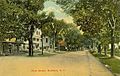
Main Street around 1910
-
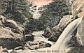
Minnewawa Glen in 1912
-
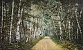
"Birch Avenue" in 1907


See also
 In Spanish: Marlborough (Nuevo Hampshire) para niños
