
Harrisville, New Hampshire facts for kids
Quick facts for kids
Harrisville, New Hampshire
|
|
|---|---|
|
Town
|
|

The historic mill village of Harrisville
|
|

Location in Cheshire County, New Hampshire
|
|
| Country | United States |
| State | New Hampshire |
| County | Cheshire |
| Incorporated | 1870 |
| Villages | |
| Area | |
| • Total | 20.2 sq mi (52.4 km2) |
| • Land | 18.6 sq mi (48.3 km2) |
| • Water | 1.6 sq mi (4.1 km2) 7.79% |
| Elevation | 1,335 ft (407 m) |
| Population
(2020)
|
|
| • Total | 984 |
| • Density | 53/sq mi (20.4/km2) |
| Time zone | UTC-5 (Eastern) |
| • Summer (DST) | UTC-4 (Eastern) |
| ZIP code |
03450
|
| Area code(s) | 603 |
| FIPS code | 33-34420 |
| GNIS feature ID | 0873620 |
Harrisville is a small, historic town in Cheshire County, New Hampshire, United States. It is known for its old mill buildings and beautiful natural surroundings. Besides the town center, it also includes the villages of Chesham and Eastview. In 2020, the town had a population of 984 people.
Harrisville is a well-preserved 19th-century mill town located in the scenic Monadnock region of southern New Hampshire. The town has nine bodies of water, many back roads, and trails to explore. You can also find two original train depots in Harrisville and Chesham.
Contents
Exploring Harrisville's Past: A Historic Mill Town
Harrisville was first known as "Twitchell's Mills." In 1774, a combination sawmill and gristmill was built here. The town of Harrisville was officially formed in 1870. It was created from parts of nearby towns like Marlborough, Dublin, and Nelson.
The Rise of Textile Mills
The Manchester & Keene Railroad opened in 1878. This helped Harrisville grow as a textile mill town. The town was named after Milan Harris. His stone and brick Cheshire Mills operated until 1970. These mills still look almost the same as they did in the mid-1800s.
A National Historic Landmark Village
Today, the Cheshire Mills are part of the Harrisville Historic District. This district is a National Historic Landmark. This means it is a very important historical place in the United States. The district includes the center of town. With its red brick buildings and mills reflected in Harrisville Pond, the village is often photographed. It is a perfect example of a picturesque old New England town. The Harrisville Rural District covers the southern part of town near the Dublin border.
-
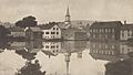
Town view c. 1905
-
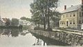
Looking up canal in 1914
-
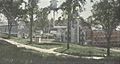
Cheshire Mills c. 1915


Geography: Lakes, Hills, and Waterways
Harrisville covers a total area of about 52.4 square kilometers (20.2 square miles). Most of this is land, with about 4.1 square kilometers (1.6 square miles) being water. Water makes up about 7.79% of the town's total area.
Highest Point and Water Basins
The highest point in Harrisville is the top of Cobb Hill. It stands at 1,909 feet (582 meters) above sea level. The town's water flows into two main river systems. The western half of Harrisville drains into the Ashuelot River watershed. This is part of the larger Connecticut River basin. The eastern half drains into the Contoocook River watershed, which is part of the Merrimack River basin.
Important Water Bodies
Several important lakes and reservoirs are found in Harrisville. On the western side, you'll find Silver Lake, Seaver Reservoir, and Chesham Pond. On the eastern side, Harrisville Pond and Skatutakee Lake are key water bodies.
Neighboring Towns
Harrisville shares its borders with several other towns:
- Nelson (north)
- Hancock (east)
- Peterborough (southeast)
- Dublin (south)
- Marlborough (southwest)
- Roxbury (west)
Community Churches in Harrisville
The Community Church of Harrisville and Chesham was formed by combining two older churches. These were the Chesham Baptist Church and the Harrisville Congregational Church.
History of Local Churches
The Chesham Baptist Church dates back to 1785. Its original building was constructed in 1797 and later remodeled in 1830 and 1844. The Evangelical Congregational Church of Harrisville started in 1840. Its church building was built between 1840 and 1843.
Current Church Status
Today, the Community Church is a member of the United Church of Christ (UCC) and the American Baptist Association. The united congregation now uses only the brick church building in Harrisville village. The church building in Chesham is owned by the American Baptist Association of Vermont & New Hampshire and is no longer used by the Community Church.
Harrisville was also home to St. Denis Parish of the Roman Catholic Church from 1902 to 2010. Services ended when it merged with other parishes. The former church building is now owned by Historic Harrisville and is called St. Denis Hall.
Population and People of Harrisville
| Historical population | |||
|---|---|---|---|
| Census | Pop. | %± | |
| 1880 | 870 | — | |
| 1890 | 748 | −14.0% | |
| 1900 | 791 | 5.7% | |
| 1910 | 623 | −21.2% | |
| 1920 | 559 | −10.3% | |
| 1930 | 512 | −8.4% | |
| 1940 | 509 | −0.6% | |
| 1950 | 519 | 2.0% | |
| 1960 | 459 | −11.6% | |
| 1970 | 584 | 27.2% | |
| 1980 | 860 | 47.3% | |
| 1990 | 981 | 14.1% | |
| 2000 | 1,075 | 9.6% | |
| 2010 | 961 | −10.6% | |
| 2020 | 984 | 2.4% | |
| U.S. Decennial Census | |||
In 2020, there were 984 people living in Harrisville. There were 416 households and 271 families. The population density was about 20.4 people per square kilometer (48.7 per square mile). There were 680 housing units in the town.
Diversity in Harrisville
Most of the people in Harrisville are White, making up about 94.3% of the population. Other groups include 0.4% African American, 0.1% Native American, and 0.9% Asian. About 0.7% of the population identified as some other race, and 3.6% identified as two or more races. People of Hispanic or Latino background made up 1.52% of the population.
Age Groups in the Town
In 2000, about 24.8% of the population was under 18 years old. About 15.0% of the population was 65 years of age or older. The average age in Harrisville was 43 years.
Education: Learning in Harrisville
The elementary school for children in Harrisville is Wells Memorial School. It is located in the village of Chesham.
See also
 In Spanish: Harrisville (Nuevo Hampshire) para niños
