
Sanford, Maine facts for kids
Quick facts for kids
Sanford
|
||
|---|---|---|

Sanford in 2014
|
||
|
||
| Nickname(s):
The heart of York County
|
||

Location of city of Sanford in map of Maine
|
||

Sanford
Location in the United States
|
||
| Country | United States | |
| State | Maine | |
| County | York | |
| Settled | 1739 | |
| Incorporated | Town: February 27, 1768 City: January 1, 2013 | |
| Government | ||
| • Type | City Council/Mayor | |
| Area | ||
| • Total | 48.75 sq mi (126.27 km2) | |
| • Land | 47.79 sq mi (123.78 km2) | |
| • Water | 0.96 sq mi (2.50 km2) | |
| Elevation | 262 ft (80 m) | |
| Population
(2020)
|
||
| • Total | 21,982 | |
| • Density | 459.97/sq mi (177.59/km2) | |
| Time zone | UTC−5 (Eastern (EST)) | |
| • Summer (DST) | UTC−4 (EDT) | |
| ZIP Codes |
04073 and 04083
|
|
| Area code(s) | 207 | |
| FIPS code | 23-65760 | |
| GNIS feature ID | 0582712 | |
| Website | www.sanfordmaine.org | |

Sanford is a city in York County, Maine, United States. In 2020, about 21,982 people lived there. This makes it the seventh largest city in Maine.
Sanford is located on the Mousam River. It includes a small community called Springvale. The city has many lakes surrounded by forests. These lakes are popular spots for campers.
Sanford is part of the larger Portland-South Portland-Biddeford metropolitan area.
On November 6, 2012, people in Sanford voted for a new way to run their town. They decided to become a city. This meant they would have a city council and a mayor, instead of just town meetings. This change started on January 1, 2013.
The first mayor of Sanford was Maura A. Herlihy. She was chosen from the city council members. Later, in 2014, people started electing a mayor directly. Thomas Cote was the first mayor elected this way. Since 2016, the mayor has been elected every two years.
Contents
History of Sanford
Sanford is in the western part of a large area of land. This land was bought in 1661 from an Abenaki Chief named Fluellin. The buyer was Major William Phillips, who owned mills in Saco.
At first, the area was called Phillipstown. In 1696, Mrs. Phillips gave the land to her former husband's son, Peleg Sanford. But people could not settle there right away. This was because of fighting during the French and Indian Wars.
In 1724, a Native American fort called Norridgewock was destroyed. This made the area safer. So, people finally started settling in Sanford in 1739. It became an official town in 1768 and was named after Peleg Sanford.
Sanford's Mills and Growth
The Mousam River was very important for industry. It provided water power for factories. In 1745, Captain Market Morrison built a sawmill near Springvale.
After the Civil War, Sanford became a big center for making textiles (cloth). The Portland and Rochester Railroad helped connect Sanford to markets. Factories were built in both Springvale and Sanford villages. They made things like cotton and woolen goods, carpets, shoes, and lumber.
In 1867, Thomas Goodall, who was from Britain, started the Goodall Mills in Sanford. His factory made carriage robes and blankets. It grew to make special fabrics for train seats, carpets, and even military uniforms.


The fabrics from Goodall Mills were known for their bright colors. They were sold all over the world. Between 1880 and 1910, the town's population grew from 2,700 to over 9,000 people. Many workers lived in houses built by the company.
The Goodall family also helped build many important places in Sanford. They built Goodall Park, a baseball stadium, in 1914. They also helped with the library, town hall, hospital, airport, and golf club. In 1917, a statue of Thomas Goodall was put up in Central Park to honor him.
Changes and New Industries
In 1954, a large textile company called Burlington Mills bought Sanford Mills. They moved the machines to their factories in the Southern United States. This caused Sanford Mills to close. About 3,600 people lost their jobs.
But the people of Sanford did not give up. Local business owners worked hard to bring new companies to the area. Life Magazine even called Sanford "the town that refused to die." Now, Sanford has many different types of industries, including making aircraft parts.
In the 1960s, the government offered money to improve older parts of towns. More than thirty buildings in Sanford were torn down. In Springvale, three out of four main corners were changed. However, many beautiful old buildings from the mill era still remain.
Sanford was also home to Belle Ashton Leavitt. She was the third woman lawyer to be allowed to practice law in Maine. She became a lawyer in 1900.
Geography of Sanford
Sanford is located at 43°26′23″N 70°46′23″W / 43.43972°N 70.77306°W. The city covers about 48.75 square miles (126.27 square kilometers). Most of this is land, and a small part is water. Sanford is near hills and the Mousam River flows through it.
The highest point in Sanford is Mt. Hope, which is 680 feet (207 meters) above sea level. The lowest point is about 140 feet (42.7 meters) above sea level, along the Mousam River.
Sanford shares borders with several other towns. These include Shapleigh, Acton, Alfred, Kennebunk, Wells, North Berwick, and Lebanon.
Population Information
| Historical population | |||
|---|---|---|---|
| Census | Pop. | %± | |
| 1790 | 1,799 | — | |
| 1800 | 1,363 | −24.2% | |
| 1810 | 1,492 | 9.5% | |
| 1820 | 1,831 | 22.7% | |
| 1830 | 2,327 | 27.1% | |
| 1840 | 2,233 | −4.0% | |
| 1850 | 2,330 | 4.3% | |
| 1860 | 2,221 | −4.7% | |
| 1870 | 2,397 | 7.9% | |
| 1880 | 2,734 | 14.1% | |
| 1890 | 4,201 | 53.7% | |
| 1900 | 6,078 | 44.7% | |
| 1910 | 9,049 | 48.9% | |
| 1920 | 10,691 | 18.1% | |
| 1930 | 13,392 | 25.3% | |
| 1940 | 14,886 | 11.2% | |
| 1950 | 15,177 | 2.0% | |
| 1960 | 14,962 | −1.4% | |
| 1970 | 15,812 | 5.7% | |
| 1980 | 18,020 | 14.0% | |
| 1990 | 20,463 | 13.6% | |
| 2000 | 20,806 | 1.7% | |
| 2010 | 20,798 | 0.0% | |
| 2020 | 21,982 | 5.7% | |
| 2022 (est.) | 22,266 | 7.1% | |
Sanford's People in 2010
In 2010, there were 20,798 people living in Sanford. There were about 8,500 households. Most people (94.7%) were White. Other groups included African American, Native American, and Asian people. About 1.6% of the population was Hispanic or Latino.
About 30.6% of households had children under 18 living with them. The average age in Sanford was 40.5 years old. About 22.6% of residents were under 18.
Sanford Fire Department
The Sanford Fire Department helps keep citizens safe. Firefighter/EMTs work from three fire stations. These are located in Springvale, South Sanford, and Downtown Sanford.
They have 3 Engines, 1 Ladder truck, and 1 Rescue vehicle. These are ready 24 hours a day, every day of the year. The department has 45 full-time firefighters. All firefighters must have a Maine EMS license. In 2007, they responded to over 3,600 emergencies.
Sanford School System
In 2018, a new high school was built in Sanford. It cost about $103 million, with most of the money coming from the state.
This school focuses on helping students prepare for future careers. It has four different sections. Students can choose special courses that match their career interests.
Places to Visit in Sanford
- Louis B. Goodall Memorial Library
- Springvale Public Library
- Sanford-Springvale Historical Society & Museum
- Goodall Park - A Baseball stadium. It is home to the Sanford Mainers, a baseball team that has won two championships.
- Mousam River
Events in Sanford
- Sanford International Film Festival—This is an event held every year. It shows independent films.
Famous People from Sanford

- Frank Augustus Allen, who was mayor of Cambridge, Massachusetts in 1877.
- Randy Brooks, a musician.
- Nick Curran, a musician.
- Vic Firth, a musician and businessman.
- Louis B. Goodall, a businessman and U.S. congressman.
- Rachel Griffin-Accurso, known as Ms. Rachel, a popular YouTuber and educator who grew up in Sanford.
- Sumner Increase Kimball, who helped start the United States Life-Saving Service.
- Peter Kostis, a golf instructor and sportscaster.
- Freddy Parent, a Major League Baseball player from 1899 to 1911.
- Rachel Schneider an Olympic Runner.
- John Storer, who has a college named after him.
Images for kids
-
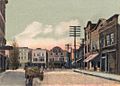
Central Square around 1905
-
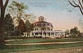
Goodall Mansion in 1910
-
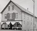
Leavitt & Company around 1892
-
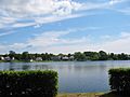
Number One Pond
-

Moon over Gowen Park
-
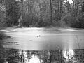
MacDougal Pond


See also
 In Spanish: Sanford (Maine) para niños
