
Kennebunk, Maine facts for kids
Quick facts for kids
Kennebunk
|
||
|---|---|---|

First Parish Church in 1909
|
||
|
||
| Nickname(s):
“The Only Town in the World, So Named & Famed”
|
||
| Motto(s):
"The only village in the world so named"
|
||

Kennebunk
Location in Maine
|
||
| Country | United States | |
| State | Maine | |
| County | York | |
| Incorporated | June 24, 1820 | |
| Boroughs |
List
Constituent Communities & Villages:
• Kennebunk Village • Kennebunk Landing • Lower Village • West Kennebunk • Bartlett Mills • Kennebunk Beach / Goochs Beach • Lords Point • Sea Road Crossing • Webhannet Grove • Coopers Crossing • Cheshire Meadows • Brine Pines |
|
| Government | ||
| • Type | Town Meeting | |
| Area | ||
| • Total | 43.87 sq mi (113.62 km2) | |
| • Land | 35.05 sq mi (90.78 km2) | |
| • Water | 8.82 sq mi (22.84 km2) | |
| Elevation | 92 ft (28 m) | |
| Population
(2020)
|
||
| • Total | 11,536 | |
| • Density | 329/sq mi (127.1/km2) | |
| Time zone | UTC-5 (Eastern (EST)) | |
| • Summer (DST) | UTC-4 (EDT) | |
| ZIP code |
04043
|
|
| Area code(s) | 207 | |
| FIPS code | 23-36535 | |
| GNIS feature ID | 0582539 | |

Kennebunk is a town in York County, Maine, United States. In 2020, about 11,536 people lived there. Kennebunk is famous for its beautiful beaches. It is also home to the Rachel Carson National Wildlife Refuge. You can find many old homes built by shipbuilders here. The town also has the Brick Store Museum and the Kennebunk Plains. These plains have 1,500 acres of nature trails and blueberry fields.
The town includes several smaller areas, like Kennebunk Village and Kennebunk Beach. It's important to know that Kennebunk is a separate town from Kennebunkport.
Contents
History of Kennebunk
Kennebunk was first settled in 1621. It grew into a busy center for trade, shipbuilding, and shipping. The town was once part of Wells and Arundel. But in 1820, it became its own separate town.
The name "Kennebunk" comes from the Abenaki people. It means "the long cut bank." This likely refers to the long bank behind Kennebunk Beach.
In the 1800s and early 1900s, many factories came to Kennebunk. They used the power of the Mousam River to run their machines. Companies like Kennebunk Manufacturing and Leatheroid worked here.
A famous tree, the Lafayette Elm, was planted in 1825. It honored General Lafayette's visit to Kennebunk. This elm tree was special because it survived a disease that killed many other elm trees. You can even see this tree on the town's official seal.
Today, the old Kesslen Shoe Mill is now called the Lafayette Center. Kennebunk also has two of Maine's oldest banks: Ocean Bank (from 1854) and Kennebunk Savings Bank (from 1871).
You can learn more about the town's past at the Brick Store Museum. It's a local history and art center on Main Street.
-
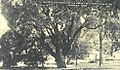
The Lafayette Elm, a famous tree in Kennebunk
-
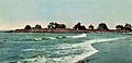
Kennebunk Beach in 1905
-
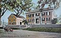
The historic Storer Mansion in 1909
-
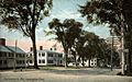
Lexington elms in Kennebunk in 1908


Geography of Kennebunk


Kennebunk covers about 43.87 square miles (113.62 square kilometers). Most of this area is land, but about 8.82 square miles (22.84 square kilometers) is water. The town has two main rivers: the Kennebunk River and the Mousam River.
Getting Around Kennebunk
Several major roads pass through Kennebunk:
- Interstate 95
- U.S. Route 1 (which is part of the main street)
- Route 9A
- Route 35
You might see Amtrak passenger trains go through Kennebunk. However, they do not stop at the old train station there anymore. The closest train stops are in Wells (to the south) or Saco (to the north).
Neighboring Towns
Kennebunk shares its borders with several other towns:
- Arundel (to the north)
- Kennebunkport (to the north)
- Wells (to the south)
- Sanford (to the west)
- Alfred (to the west)
- Lyman (to the northwest)
Kennebunk's Beaches
Kennebunk has a beautiful coastline with several popular beaches. The three main sections are:
- Mother's Beach
- Middle Beach (also called Rocky Beach)
- Gooch's Beach (or Long Beach)
There is also a quieter beach called Parson's Beach. It's a good choice if you want to avoid summer crowds.
There's a small debate about the name "Mother's Beach." Some local people say its official name is Kennebunk Beach or Boothby Beach. The name "Mother's Beach" likely became popular because its small size and calm water make it a safe place for children to swim. This makes it a favorite spot for parents to watch their kids.
Other beaches in Kennebunk include Libbys and Crescent beaches. However, these do not have public parking.
People of Kennebunk

The population of Kennebunk has grown steadily over the years.
| Historical population | |||
|---|---|---|---|
| Census | Pop. | %± | |
| 1820 | 2,145 | — | |
| 1830 | 2,233 | 4.1% | |
| 1840 | 2,323 | 4.0% | |
| 1850 | 2,650 | 14.1% | |
| 1860 | 2,679 | 1.1% | |
| 1870 | 2,603 | −2.8% | |
| 1880 | 2,852 | 9.6% | |
| 1890 | 3,172 | 11.2% | |
| 1900 | 3,228 | 1.8% | |
| 1910 | 3,099 | −4.0% | |
| 1920 | 3,138 | 1.3% | |
| 1930 | 3,302 | 5.2% | |
| 1940 | 3,698 | 12.0% | |
| 1950 | 4,273 | 15.5% | |
| 1960 | 4,551 | 6.5% | |
| 1970 | 5,646 | 24.1% | |
| 1980 | 6,621 | 17.3% | |
| 1990 | 8,004 | 20.9% | |
| 2000 | 10,476 | 30.9% | |
| 2010 | 10,798 | 3.1% | |
| 2020 | 11,536 | 6.8% | |
In 2010, about 10,798 people lived in Kennebunk. The town had 4,689 households. Most people living in Kennebunk were White (96.9%). The average age of people in Kennebunk was about 48 years old.
Economy of Kennebunk

Kennebunk is home to the company Tom's of Maine. They make natural health-care products like toothpaste. Many people who live in Kennebunk also travel to work in nearby cities like Portland. Some even commute to other states like New Hampshire or Massachusetts.
Tourism in Kennebunk
Tourism is a big part of Kennebunk's economy, especially in the summer. Many visitors come to enjoy the town's charm. Summer Street was the first area in Maine to be listed on the National Register of Historic Places because of its history.
Kennebunk has many beautiful old buildings. One of the most famous is the Wedding Cake House. It's a unique house with lots of fancy decorations. People used to think a ship captain built it for his wife, but it was actually decorated by George Washington Bourne for his wife much later in his life.
Places to Visit in Kennebunk
- Brick Store Museum: Learn about local history and art.
- Wedding Cake House: See this famous, uniquely decorated house.
- Rachel Carson National Wildlife Refuge: Explore nature and see wildlife.
- Kennebunk River Club: A historic club by the river.
Education in Kennebunk
Kennebunk is part of Regional School District 21, along with Kennebunkport and Arundel. The schools in this district include:
- Consolidated School
- Kennebunk Elementary School
- Mildred L. Day School
- Sea Road School
- Middle School of the Kennebunks
- Kennebunk High School
The Middle School of the Kennebunks is part of the Maine Learning Technology Initiative (MLTI). This program gives laptops to all 6th, 7th, and 8th graders in the school.
In 2000, some students, parents, and community members started The New School. This is a small, alternative high school. It focuses on learning that involves the local community.
Notable People from Kennebunk

Many interesting people have lived in or come from Kennebunk:
- Edward H. Betts: A painter and art teacher.
- Kate Chappell and Tom Chappell: Businesspeople who founded Tom's of Maine.
- Eunice Hale Waite Cobb: A writer and activist.
- Jack Coombs: A baseball player.
- Joseph Dane: A US congressman.
- Judith Hunt: An illustrator.
- Hugh McCulloch: A former Secretary of the U.S. Treasury.
- Brooke McEldowney: A cartoonist.
- Bruce McMillan: A children's book author and artist.
- Edmund S. Muskie: A US Senator and Secretary of State.
- Jeff Olson: A musician.
- Kenneth Roberts: A famous author.
- Clement Storer: A US congressman and senator.
- Mary Alice Willcox: A zoologist.
See also
 In Spanish: Kennebunk (Maine) para niños
