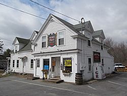
Arundel, Maine facts for kids
Quick facts for kids
Arundel, Maine
|
|
|---|---|

Winks Place
|
|
| Motto(s):
Where People Matter
|
|
| Country | United States |
| State | Maine |
| County | York |
| Incorporated | 1915 |
| Government | |
| • Type | Board of Selectmen |
| Area | |
| • Total | 23.90 sq mi (61.90 km2) |
| • Land | 23.87 sq mi (61.82 km2) |
| • Water | 0.03 sq mi (0.08 km2) |
| Elevation | 105 ft (32 m) |
| Population
(2020)
|
|
| • Total | 4,264 |
| • Density | 179/sq mi (69.0/km2) |
| Time zone | UTC-5 (Eastern (EST)) |
| • Summer (DST) | UTC-4 (EDT) |
| ZIP code |
04046
|
| Area code(s) | 207 |
| FIPS code | 23-01605 |
| GNIS feature ID | 0582330 |
| Website | www.arundelmaine.org |
Arundel is a town in York County, Maine, United States. It is a part of New England. In 2020, about 4,264 people lived there. Arundel is also part of the larger Portland area.
The town includes several small communities. Some of these are Arundel Village, Vinegar Hill, and Log Cabin Crossing. Arundel is located next to the towns of Kennebunkport and Biddeford. In 2014, a magazine called Downeast Magazine named Arundel the "Best Place to Live in Maine."
Contents
Arundel's History
The area we now call Arundel was once part of Kennebunkport. This was true until 1915. In that year, it became its own town. It was first named North Kennebunkport.
Later, in 1957, the town's name changed again. This happened after a famous author, Kenneth Roberts, wrote books called Chronicles of Arundel. The state government then decided to rename the town. They named it after Lord Arundel.
Did you know Kennebunkport itself was also called Arundel a long time ago? It had that name from 1701 to 1821. The name Arundel originally came from a town in West Sussex, England.
Where is Arundel Located?
Arundel is a town with a total area of about 23.90 square miles (61.90 square kilometers). Most of this area is land, about 23.87 square miles (61.82 square kilometers). Only a small part, 0.03 square miles (0.08 square kilometers), is water. The Kennebunk River flows through Arundel.
Major roads like Interstate 95 and U.S. Route 1 pass through the town. State routes 35 and 111 are also in Arundel.
Arundel shares its borders with several other towns. To the southeast is Kennebunkport. To the southwest is Kennebunk. Lyman is to the northwest. Dayton is to the north, and Biddeford is to the northeast.
People in Arundel
| Historical population | |||
|---|---|---|---|
| Census | Pop. | %± | |
| 1790 | 1,458 | — | |
| 1800 | 1,900 | 30.3% | |
| 1810 | 2,371 | 24.8% | |
| 1820 | 2,478 | 4.5% | |
| 1920 | 564 | — | |
| 1930 | 545 | −3.4% | |
| 1940 | 866 | 58.9% | |
| 1950 | 939 | 8.4% | |
| 1960 | 907 | −3.4% | |
| 1970 | 1,322 | 45.8% | |
| 1980 | 2,150 | 62.6% | |
| 1990 | 2,669 | 24.1% | |
| 2000 | 3,571 | 33.8% | |
| 2010 | 4,022 | 12.6% | |
| 2020 | 4,264 | 6.0% | |
Population in 2010
In 2010, about 4,022 people lived in Arundel. There were 1,569 households, which are groups of people living together. Most people in Arundel were White (96.6%).
About 22% of the people living in Arundel were under 18 years old. Around 12.2% were 65 years old or older. The average age in the town was about 42.9 years.
Schools in Arundel
Arundel is part of the RSU21 school district. This district also includes the towns of Kennebunk and Kennebunkport.
For many years, students from Arundel had a special choice. They could attend Thornton Academy for grades 9-12. They could also go to Thornton Academy Middle School for grades 6-8. The town of Arundel would pay for their tuition.
There was a disagreement about this school choice option. However, the Maine Supreme Judicial Court made a decision in 2019. This decision means that students from Arundel can still choose to attend Thornton Academy schools.
The elementary school for Arundel children is Mildred L. Day School. Kids from kindergarten to fifth grade go to school there.
Nearby Towns
See also
 In Spanish: Arundel (Maine) para niños
 | Georgia Louise Harris Brown |
 | Julian Abele |
 | Norma Merrick Sklarek |
 | William Sidney Pittman |


