Lyman, Maine facts for kids
Quick facts for kids
Lyman, Maine
|
|
|---|---|

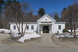
Lyman Town Hall
|
|
| Country | United States |
| State | Maine |
| County | York |
| Incorporated | 1780 |
| Area | |
| • Total | 40.49 sq mi (104.87 km2) |
| • Land | 38.99 sq mi (100.98 km2) |
| • Water | 1.50 sq mi (3.88 km2) |
| Elevation | 272 ft (83 m) |
| Population
(2020)
|
|
| • Total | 4,525 |
| • Density | 116/sq mi (44.8/km2) |
| Time zone | UTC-5 (Eastern (EST)) |
| • Summer (DST) | UTC-4 (EDT) |
| ZIP code |
04002
|
| Area code(s) | 207 |
| FIPS code | 23-41750 |
| GNIS feature ID | 0582572 |
Lyman is a town in York County, Maine, United States. It is a part of the Portland metropolitan area. In 2020, about 4,525 people lived there. Lyman is also home to the Massabesic Experimental Forest, which it shares with the nearby town of Alfred.
Contents
History of Lyman
Early Days and First Settlers
In 1660, a group of people including John Sanders bought land from the Abenaki leader Sosowen. This land is now the town of Lyman. It was first called Swanfield and people started settling there in 1767.
Some of the first families to live in Swanfield were the Waterhouses, Love Roberts, Alexander Grant, and Thomas Lord. Other early settlers included the Goodwin brothers, who built one of the first mills. John Low, who helped run the town, also lived there.
Becoming a Town
Swanfield officially became a town on April 24, 1780. The government of Massachusetts named it Coxhall. This name probably came from a town in England called Coggeshall.
Later, on February 25, 1803, the town's name was changed to Lyman. This was done to honor Theodore Lyman. He was a rich merchant who had a successful shipping business.
Life and Work in Lyman
The farmers in Lyman found that the land was a bit bumpy. But the soil was good for growing crops. They grew grains, hay, and apples.
People also built watermills near the larger ponds. There were two sawmills at Swan Pond and another at Kennebunk Pond. Cutting and selling lumber was a big way for many people to earn money.
In 1782, a sawmill and a gristmill were built at Goodwin's Mills. This area became the main place for businesses in town. Part of this village is actually in the town of Dayton.
In 1947, large fires caused a lot of damage in Lyman. Today, Lyman is mostly a bedroom community. This means many people who live there travel to other towns for work.
Geography of Lyman
Land and Water
Lyman covers a total area of about 40.49 square miles (104.87 square kilometers). Most of this area is land, about 38.99 square miles (100.98 square kilometers). The rest, about 1.50 square miles (3.88 square kilometers), is water. The Kennebunk River flows through Lyman.
Roads and Neighbors
Several important roads cross through Lyman. These include U.S. Route 202 and State Routes 5, 35, and 111.
Lyman shares its borders with several other towns. To the northeast are Hollis and Dayton. To the southeast are Arundel and Kennebunk. Alfred is to the southwest, and Waterboro is to the northwest.
Population of Lyman
| Historical population | |||
|---|---|---|---|
| Census | Pop. | %± | |
| 1790 | 765 | — | |
| 1800 | 995 | 30.1% | |
| 1810 | 1,248 | 25.4% | |
| 1820 | 1,387 | 11.1% | |
| 1830 | 1,503 | 8.4% | |
| 1840 | 1,478 | −1.7% | |
| 1850 | 1,376 | −6.9% | |
| 1860 | 1,307 | −5.0% | |
| 1870 | 1,052 | −19.5% | |
| 1880 | 1,004 | −4.6% | |
| 1890 | 854 | −14.9% | |
| 1900 | 687 | −19.6% | |
| 1910 | 615 | −10.5% | |
| 1920 | 415 | −32.5% | |
| 1930 | 370 | −10.8% | |
| 1940 | 385 | 4.1% | |
| 1950 | 499 | 29.6% | |
| 1960 | 529 | 6.0% | |
| 1970 | 864 | 63.3% | |
| 1980 | 2,509 | 190.4% | |
| 1990 | 3,390 | 35.1% | |
| 2000 | 3,795 | 11.9% | |
| 2010 | 4,344 | 14.5% | |
| 2020 | 4,525 | 4.2% | |
| U.S. Decennial Census | |||
How Many People Live Here?
The census is a count of all the people living in an area. In 2010, there were 4,344 people living in Lyman. These people lived in 1,660 households. A household means all the people living in one home.
The average age of people in Lyman in 2010 was about 43 years old. About 21.5% of the residents were under 18 years old. About 13.2% of the residents were 65 years or older.
See also
 In Spanish: Lyman (Maine) para niños
 | Leon Lynch |
 | Milton P. Webster |
 | Ferdinand Smith |


