Richmond, New Hampshire facts for kids
Quick facts for kids
Richmond, New Hampshire
|
||
|---|---|---|
|
Town
|
||

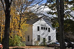
Town hall
|
||
|
||

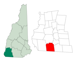
Location in Cheshire County, New Hampshire
|
||
| Country | United States | |
| State | New Hampshire | |
| County | Cheshire | |
| Incorporated | 1752 | |
| Named for | Charles Lennox, 3rd Duke of Richmond | |
| Villages |
|
|
| Area | ||
| • Total | 37.7 sq mi (97.7 km2) | |
| • Land | 37.5 sq mi (97.2 km2) | |
| • Water | 0.2 sq mi (0.5 km2) 0.52% | |
| Elevation | 1,063 ft (324 m) | |
| Population
(2020)
|
||
| • Total | 1,197 | |
| • Density | 32/sq mi (12.3/km2) | |
| Time zone | UTC-5 (Eastern) | |
| • Summer (DST) | UTC-4 (Eastern) | |
| ZIP code |
03470
|
|
| Area code(s) | 603 | |
| FIPS code | 33-64420 | |
| GNIS feature ID | 0873706 | |
Richmond is a small town in Cheshire County, New Hampshire, in the United States. In 2020, about 1,197 people lived there. It is known as a typical New England town.
Contents
History of Richmond
The area that is now Richmond was first given a special paper, called a charter, in 1735. This was done by Governor Jonathan Belcher of Massachusetts. The land was given to soldiers who came back from a war in Canada. It was first called "Sylvester-Canada." This name honored Captain Joseph Sylvester, who died in 1690 trying to capture Quebec.
Later, the border between Massachusetts and New Hampshire was set. Richmond ended up on the New Hampshire side. In 1752, Governor Benning Wentworth officially made it a town. He named it "Richmond" after Charles Lennox, the 3rd Duke of Richmond. The Duke was a strong supporter of the American colonies. People from Rhode Island and Massachusetts started settling in Richmond around 1757.
Geography and Nature
Richmond covers a total area of about 97.7 square kilometers (37.7 square miles). Most of this area, about 97.2 square kilometers (37.5 square miles), is land. Only a small part, about 0.5 square kilometers (0.2 square miles), is water.
Little Monadnock Mountain is a tall point near Richmond. It is about 1,883 feet (574 meters) above sea level. The highest spot in Richmond itself is on an unnamed hill. This hill is about 1,624 feet (495 meters) above sea level. In the western part of town, you can find the Franconia Mountain Range. These are hills that are about 1,300 feet (400 meters) high.
Two main roads, Route 32 and Route 119, help people travel through Richmond.
Neighboring Towns
Richmond shares its borders with several other towns:
- Swanzey (to the north)
- Troy (to the northeast)
- Fitzwilliam (to the east)
- Royalston, Massachusetts (to the southeast)
- Warwick, Massachusetts (to the southwest)
- Winchester (to the west)
Population Changes
The number of people living in Richmond has changed a lot over the years. Here's a look at how the population has grown and shrunk:
| Historical population | |||
|---|---|---|---|
| Census | Pop. | %± | |
| 1790 | 1,380 | — | |
| 1800 | 1,390 | 0.7% | |
| 1810 | 1,290 | −7.2% | |
| 1820 | 1,391 | 7.8% | |
| 1830 | 1,301 | −6.5% | |
| 1840 | 1,165 | −10.5% | |
| 1850 | 1,128 | −3.2% | |
| 1860 | 1,015 | −10.0% | |
| 1870 | 868 | −14.5% | |
| 1880 | 669 | −22.9% | |
| 1890 | 476 | −28.8% | |
| 1900 | 459 | −3.6% | |
| 1910 | 393 | −14.4% | |
| 1920 | 306 | −22.1% | |
| 1930 | 241 | −21.2% | |
| 1940 | 296 | 22.8% | |
| 1950 | 259 | −12.5% | |
| 1960 | 295 | 13.9% | |
| 1970 | 287 | −2.7% | |
| 1980 | 518 | 80.5% | |
| 1990 | 877 | 69.3% | |
| 2000 | 1,077 | 22.8% | |
| 2010 | 1,155 | 7.2% | |
| 2020 | 1,197 | 3.6% | |
| U.S. Decennial Census | |||
According to the census from 2000, there were 1,077 people living in Richmond. About 35% of the homes had children under 18 living there. The average age of people in town was 38 years old.
Places of Worship
In the center of Richmond, at Richmond Four Corners, you can find the Richmond Community United Methodist Church. This church is a brick building built in 1837. It has a style called Greek revival.
Famous People from Richmond
Several notable people have come from Richmond:
- Hosea Ballou (1771–1852) was a well-known clergyman and theologian.
- Horatio Admiral Nelson (1816–1882) was a merchant and politician in Quebec.
- Joseph Weeks (1773–1845) served as a US congressman.
See also
 In Spanish: Richmond (Nuevo Hampshire) para niños
 | Roy Wilkins |
 | John Lewis |
 | Linda Carol Brown |


