
Truskmore facts for kids
Quick facts for kids Truskmore |
|
|---|---|
| Trosc Mór | |

Truskmore seen from Gleniff Horseshoe Drive
|
|
| Highest point | |
| Elevation | 647 m (2,123 ft) |
| Prominence | 560 m (1,840 ft) |
| Listing | County Top (Sligo), Marilyn, Hewitt |
| Naming | |
| English translation | big cod (fish) |
| Language of name | Irish |
| Geography | |

Truskmore
Location in island of Ireland
|
|
| Location | border of County Sligo and County Leitrim, Republic of Ireland |
| Parent range | Dartry Mountains |
| OSI/OSNI grid | G758473 |

Truskmore (which means big cod in Irish) is a mountain in Ireland. It stands 647 meters (2,123 feet) tall. You can find it on the border between County Sligo and County Leitrim.
Truskmore is the highest point in the Dartry Mountains. It is also the tallest mountain in County Sligo. The mountain is part of a large flat area called a plateau. This plateau stretches across parts of Sligo and Leitrim. The edges of this plateau have high cliffs. Some famous cliffs nearby include Benbulbin (526m) and Benwiskin (514m).
Truskmore's TV and Radio Tower
Truskmore is home to an important television transmitter. This tower helps send TV and radio signals across the North West of Ireland. The first TV signals from Truskmore started on February 1, 1962. It was one of the first major towers for RTÉ Television in Ireland.
The original tower was 135 meters tall. Later, in 1966, it also started sending FM radio signals. Over the years, new TV channels were added. In 2009, a new, taller mast was built. This new mast is 175 meters tall. It was made ready for the change to digital TV. The old mast from 1961 was then taken down.
Since October 24, 2012, Truskmore has broadcast only digital TV signals. This service is called Saorview. It also sends out national FM radio channels. The tower helps people in a large part of western Northern Ireland too. The company that owns and runs the site is 2RN. This company is part of RTÉ, Ireland's public broadcaster.
Images for kids
-
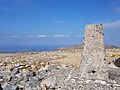
A marker at the top of Truskmore mountain
-
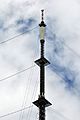
The very top of the transmission mast
-
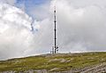
A view from the road leading up to Truskmore
-
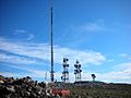
The old mast that was replaced in 2009


See also
 In Spanish: Trosc Mór para niños
