
Turtle Mountain (Alberta) facts for kids
Quick facts for kids Turtle Mountain |
|
|---|---|

Turtle Mountain.
|
|
| Highest point | |
| Elevation | 2,210 m (7,250 ft) |
| Prominence | 518 m (1,699 ft) |
| Geography | |
| Location | Alberta, Canada |
| Parent range | Blairmore Range |
| Topo map | NTS 82G/09 |
| Geology | |
| Mountain type | Limestone |
| Climbing | |
| Easiest route | Scramble |
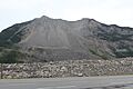
Turtle Mountain is a large mountain located in Alberta, Canada. It stands tall in the Crowsnest River Valley and is part of the Blairmore Range within the amazing Canadian Rockies. The Oldman River starts its journey from this area.
Contents
A Moving Mountain: History
Long ago, the local Indigenous peoples, like the Blackfoot and Ktunaxa, had special stories about Turtle Mountain. They called it "the mountain that moves." This name hints at the mountain's unstable nature, which was sadly proven true later on.
The Frank Slide of 1903
Turtle Mountain is most famous for a huge event that happened in 1903, known as the Frank Slide. Early in the morning on April 29, 1903, a massive part of the mountain broke off. About 30 million cubic metres (that's like 82 million tonnes!) of limestone rock crashed down.
This giant rockslide buried the eastern part of the nearby town of Frank. The town had about 600 residents at the time. Sadly, between 70 and 90 people lost their lives in this disaster. However, only 12 bodies were ever found.
Since the Frank Slide, people have been watching Turtle Mountain very closely to make sure something like that doesn't happen again. A special project to monitor the mountain was set up in 2003, 100 years after the slide.
How the Mountain Formed
Turtle Mountain is made mostly of limestone rock. Geologists, who study rocks and the Earth, call its shape an "anticline". This means the rock layers are folded upwards, like an arch.
Over time, water likely seeped into cracks at the top of the mountain. This water slowly weakened the limestone. Also, glaciers (huge sheets of ice) carved out the valley below, making the mountain's base less stable. The Crowsnest River also helped erode, or wear away, the land at the mountain's foot. All these things together made the mountain more likely to have a slide.
Watching Turtle Mountain: The Monitoring Project
Because of the Frank Slide, it's very important to keep an eye on Turtle Mountain. On April 29, 2003, exactly 100 years after the slide, the government of Alberta announced they would provide $1.1 million to start a special monitoring program for the mountain.
How the Monitoring Works
This project uses advanced technology to watch for any changes in the mountain. Scientists and engineers from different groups worked together to set up this system. By March 2005, the first parts of this high-tech system were ready and working.
The Energy Resources Conservation Board/Alberta Geological Survey (ERCB/AGS) now manages the project. They keep the monitoring system running, fix it if needed, and make it even better with new technology. They also use the information collected to do more research.
The sensors on the mountain send back data almost instantly. This data helps scientists see how the mountain is slowly moving, or "creeping." They've noticed that the mountain's movement can change with the temperature. This ongoing monitoring helps experts understand the mountain better and predict if there might be any future risks.
Images for kids
-
Turtle Mountain.
