
Tushka, Oklahoma facts for kids
Quick facts for kids
Tushka, Oklahoma
|
|
|---|---|

Location of Tushka, Oklahoma
|
|
| Country | United States |
| State | Oklahoma |
| County | Atoka |
| Area | |
| • Total | 0.76 sq mi (1.96 km2) |
| • Land | 0.76 sq mi (1.96 km2) |
| • Water | 0.00 sq mi (0.00 km2) |
| Elevation | 614 ft (187 m) |
| Population
(2020)
|
|
| • Total | 413 |
| • Density | 545.57/sq mi (210.76/km2) |
| Time zone | UTC-6 (Central (CST)) |
| • Summer (DST) | UTC-5 (CDT) |
| FIPS code | 40-75250 |
| GNIS feature ID | 2413406 |
Tushka is a small town located in Atoka County, Oklahoma, in the United States. In 2020, about 413 people lived there. This was a good increase from the 312 people counted in 2010.
Contents
History of Tushka: How the Town Began
Tushka has an interesting past, starting as a small settlement and growing over time.
Early Days: From Peck Switch to Tushka
In 1872, a railway company called Missouri-Kansas-Texas Railway (or Katy) built train tracks. These tracks were about five miles south of a town called Atoka. This led to a new settlement being formed. It was first called Peck Switch.
The town got its first post office in 1903. In 1905, its name changed to Lewis. This was to honor Charles Lewis, who was the first postmaster. A few years later, in 1909, the community was renamed Dayton. But in the same year, it got its current name: Tushka. The word Tushka comes from the Choctaw language and means "warrior."
Growing and Changing: Challenges and Comebacks
Tushka officially became a town in 1915. This is called "incorporation." But after 15 years, it stopped being an official town. In 1920, 248 people lived there.
During the Great Depression, a big fire destroyed much of the town. This was a very tough time for many people. Later, during World War II, many residents moved to California to find work. Some of them never came back.
Tushka became an official town again in 1968. By 1970, its population had grown to 230 people.
Tornado in 2011: A Difficult Event
On April 14, 2011, a powerful tornado hit Tushka. It caused a lot of damage to homes and buildings, including the local school. This was a very sad day for the town.
Where is Tushka? Geography and Location
Tushka is located in Oklahoma. It covers an area of about 0.7 square miles (1.96 square kilometers). Most of this area is land.
The town is situated along two important roads: U.S. Highway 69 and U.S. Highway 75. These highways help connect Tushka to other places.
People of Tushka: Population and Community
| Historical population | |||
|---|---|---|---|
| Census | Pop. | %± | |
| 1970 | 230 | — | |
| 1980 | 358 | 55.7% | |
| 1990 | 256 | −28.5% | |
| 2000 | 377 | 47.3% | |
| 2010 | 312 | −17.2% | |
| 2020 | 413 | 32.4% | |
| U.S. Decennial Census | |||
The number of people living in Tushka has changed over the years. Here's a quick look at the population counts from different years:
- 1970: 230 people
- 1980: 358 people
- 1990: 256 people
- 2000: 377 people
- 2010: 312 people
- 2020: 413 people
Who Lives in Tushka? A Look at the Community
In 2000, there were 345 people living in Tushka. These people lived in 139 different homes. About 94 of these homes were families.
Most people in Tushka identified as White (about 72%). A good number of residents were also Native American (about 20%). Some people identified with two or more races. About 2% of the population was Hispanic or Latino.
Families and Age Groups
In 2000, about 32% of the homes in Tushka had children under 18 living there. Nearly half of the homes (48%) were married couples living together. About 16% of homes had a female head of household without a husband present.
The average home had about 2.48 people. The average family had about 3.03 people.
The population was spread out across different age groups:
- About 27.5% were under 18 years old.
- About 12.5% were between 18 and 24 years old.
- About 27.2% were between 25 and 44 years old.
- About 20.3% were between 45 and 64 years old.
- About 12.5% were 65 years or older.
The average age in Tushka was 34 years old.
Images for kids
-
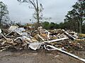
Tornado damage in Tushka, 2011

See also
 In Spanish: Tushka (Oklahoma) para niños
