Tornado outbreak of April 14–16, 2011 facts for kids
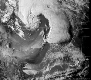
Visible satellite image of the storm at 2345 UTC on April 14
|
|
| Type | Tornado outbreak Extratropical cyclone Winter storm |
|---|---|
| Duration | April 14–16, 2011 |
| Tornadoes confirmed | 178 |
| Max rating1 | EF3 tornado |
| Duration of tornado outbreak2 | 2 days, 4 hours, 20 minutes |
| Largest hail | 4.25 inches (10.8 cm) in several locations |
| Damage | $2.1 billion (2011 USD) |
| Total fatalities | 38 fatalities (+5 non-tornadic), 588 injuries |
| 1Most severe tornado damage; see Enhanced Fujita scale 2Time from first tornado to last tornado | |
From April 14 to 16, 2011, a huge tornado outbreak hit the United States. It was one of the biggest tornado events ever recorded in U.S. history. A total of 178 tornadoes were confirmed across 16 states. These storms caused a lot of damage and destruction for three days straight.
Sadly, 38 people died because of the tornadoes. Another five people died from very strong straight-line winds that came with the storm system. This severe weather event caused 43 deaths in the Southern United States. It was the deadliest tornado outbreak in the U.S. since 2008. However, just two weeks later, an even bigger event called the 2011 Super Outbreak happened, which killed 324 people.
Contents
How the Storms Formed
April 14: Storms Begin
On April 14, a strong storm system moved from the Rocky Mountains in the south towards the central and southern Great Plains. By night, it reached the Mississippi River Valley. This system brought strong winds high up in the sky and cold air. At the same time, moist air from the Gulf of Mexico moved north. When these elements mixed, they created perfect conditions for severe weather.
The Storm Prediction Center warned that there was a moderate risk of severe weather for eastern Oklahoma and parts of Arkansas, Kansas, Missouri, and Texas. Thunderstorms started to form in Oklahoma by 3:10 pm CDT. These storms quickly grew into powerful "supercells," which are rotating thunderstorms that can create tornadoes. They moved into eastern Oklahoma by 4:00 pm CDT.
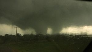
People who chase storms saw many funnel clouds. Two tornadoes touched down, but they didn't cause any damage at first. Later, a large and strong tornado caused serious damage in and around the towns of Atoka and Tushka. Many houses were destroyed. Sometimes, this tornado even had two funnels spinning at once! Many people were hurt in Tushka, and two people died there. In Arkansas, strong winds from thunderstorms killed at least seven people.
April 15: More Tornadoes in the South
On April 15, there was another moderate risk of severe weather, mainly for Alabama and Mississippi. Early that morning, the tornadoes slowed down. But by late morning, supercell thunderstorms started up again over parts of Mississippi, and more tornadoes touched down.
A "tornado emergency" was announced for the northern Jackson area around 11:00 am CDT. This happened because a tornado was seen moving through parts of Jackson and the nearby city of Clinton. This destructive tornado caused a lot of damage and hurt many people. That afternoon, weather spotters from Mississippi State University confirmed another large tornado in Mississippi and Alabama. This led to a second tornado emergency. News reports said this tornado was 3/4 mile (1.2 km) wide.
Three more tornado emergencies were issued that afternoon for other storms. One large EF3 "wedge tornado" (a very wide tornado) caused severe damage near Leakesville, Mississippi, and killed 4 people. In total, at least 7 people died from storms on April 15.
April 16: High Risk in the Carolinas
| Outbreak death toll | |||
| State/Province | Total | County | County total |
|---|---|---|---|
| Alabama | 7 | Autauga | 3 |
| Marengo | 1 | ||
| Washington | 2 | ||
| Arkansas | 2 | Pulaski | 2 |
| Mississippi | 1 | Greene | 1 |
| North Carolina | 24 | Bertie | 12 |
| Bladen | 4 | ||
| Cumberland | 1 | ||
| Harnett | 1 | ||
| Lee | 2 | ||
| Wake | 4 | ||
| Virginia | 2 | Gloucester | 2 |
| Totals | 38 | ||
| Only tornado-related deaths are included | |||
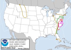
On April 16, a "moderate risk" of severe weather was issued for the Carolinas and southern Virginia. This was because a cold front was moving east. A "PDS Tornado Watch" (meaning a "Particularly Dangerous Situation") was issued shortly after noon, followed by a "high risk" warning. This was the first "high risk" warning of 2011, issued at 12:30 pm EDT for central and eastern North Carolina and nearby areas in South Carolina and Virginia.
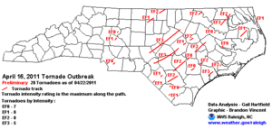
As storms moved into areas with very unstable air, a line of storms called a "squall line" rapidly grew stronger. Wind damage was reported in Salisbury and Lexington, where trees fell and roofs were damaged. The Salisbury storm was an EF1 tornado, the first confirmed tornado in North Carolina from this outbreak. More tornadoes followed near Monroe and Burlington. The Burlington storm became one of many long-lasting supercells that produced several tornadoes.
By early afternoon, the squall line broke apart into powerful, separate supercells. The atmosphere was perfect for tornadoes to form. Around 3:15 pm EDT, a tornado emergency was issued for a very strong tornado in the Raleigh-Durham area. This storm had started in Moore County and was a very strong EF3 tornado in Sanford. Weather radar showed a clear "hook echo," which is a sign of a rotating storm that can produce a tornado. It also showed hail and debris being lifted high into the air.
This tornado, which might have been a mile wide, moved through the southeast edge of downtown Raleigh. It passed through many suburbs around the city. While the damage in Wake County was mostly EF0 to EF2, debris from the more violent Sanford area was carried by the storm. The tornado crossed three major highways and just missed a nuclear power plant. The campus of Shaw University in downtown Raleigh was so badly damaged that classes were canceled for the rest of the semester.
Soon after, two more tornado emergencies were issued for other strong supercells. Large cities like Fayetteville, Jacksonville, and Wilson were directly hit by EF2 or EF3 tornadoes. A tornado that started in Fayetteville even closed Interstate 95 for a short time because of debris blocking the road.
Later in the outbreak, another EF3 tornado hit Askewville, North Carolina, in Bertie County. This tornado caused 12 deaths and a lot of damage. Other destructive tornadoes from the same line of supercells caused damage in South Carolina and Virginia. One tornado even touched down at the Surry Nuclear Power Plant in Virginia, causing a brief power outage at the plant. The storms finally moved out over the Atlantic Ocean late that evening, ending the tornado outbreak after more than 52 hours.
Tornadoes Confirmed
| EFU | EF0 | EF1 | EF2 | EF3 | EF4 | EF5 | Total |
|---|---|---|---|---|---|---|---|
| 0 | 52 | 81 | 32 | 13 | 0 | 0 | 178 |
De Kalb, Mississippi to Geiger, Alabama Tornado
| EF3 tornado | |
|---|---|
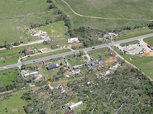
EF3 damage south of Geiger, Alabama.
|
|
| Max rating1 | EF3 tornado |
| Highest winds |
|
| Damage | $19.92 million (2011 USD) |
| Total fatalities | 5 injuries |
| 1Most severe tornado damage; see Enhanced Fujita scale | |
This strong EF3 tornado traveled a long distance. It first touched down southeast of Philadelphia, Mississippi, at 12:53 p.m. CDT. It knocked down many trees and damaged homes. As it moved, it grew stronger, reaching EF3 intensity. It destroyed chicken houses and badly damaged homes. Some mobile homes were completely destroyed, with pieces carried far away.
The tornado continued to cause widespread tree damage and knock down power lines. It passed just north of De Kalb, Mississippi, where it again caused EF3 damage. It completely destroyed a double-wide mobile home, wrapping its frame around trees. It also stripped bark from trees and snapped power poles.
The tornado reached its widest point, about 3/4 mile (1.2 km) wide, before weakening slightly. It then crossed US 45 south of Scooba, where it destroyed a large warehouse and threw a pickup truck a long distance. Thousands of acres of forest were damaged in Kemper County.
The storm then moved into Sumter County, Alabama, still as an EF3 tornado. It immediately hit Geiger, causing huge damage to many homes and businesses. Many houses and mobile homes were destroyed. East of Geiger, thousands of trees were snapped or pulled out of the ground. The tornado lifted near the Tombigbee River at 2:05 p.m. CDT. This tornado traveled about 48.52 miles (78.09 km) across three counties. It had winds up to 150 mph (240 km/h). Five people were injured in Mississippi.
Sanford to Raleigh, North Carolina Tornado
| EF3 tornado | |
|---|---|
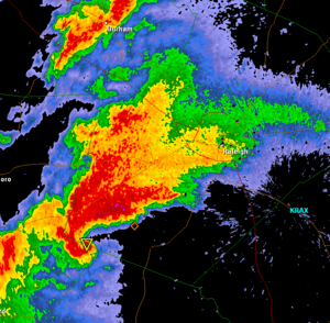
The Raleigh supercell as it is about to enter the city. The upside down triangle icon is a tornado vortex signature marker.
|
|
| Max rating1 | EF3 tornado |
| Damage | $172 million (2011 USD) |
| Total fatalities | 6 fatalities, 103 injuries |
| 1Most severe tornado damage; see Enhanced Fujita scale | |
At 2:53 p.m. EDT on April 16, a very strong tornado formed near Sanford, North Carolina. A Lowe's Home Improvement Warehouse store in Sanford was destroyed. Luckily, no one died there because staff saw the storm coming and got everyone to safety. Other stores nearby were also badly damaged. In a residential area, two people were killed, and 30 homes were destroyed. Some homes were completely flattened. This was the most severe damage, rated as a high-end EF3.
The tornado then moved northeast, following U.S. Route 1. It weakened a bit as it passed through Chatham County. As it entered Wake County, a tornado emergency was issued for areas like Raleigh.
The tornado, still an EF0/EF1, moved through Holly Springs. It knocked down many trees and power lines, damaged houses, and injured several people. Pieces of destroyed homes were carried by the wind and fell in nearby towns. The tornado continued towards downtown Raleigh. Radar showed a very clear "hook echo." The tornado passed through Raleigh's suburbs, damaging many homes. It was still an EF1 as it moved into downtown Raleigh. Many businesses near Interstate 40 were badly damaged. The Shaw University campus was also severely hit. Live camera footage showed the tornado crossing Interstate 40, with power flashes and flying debris.
After hitting downtown, the tornado continued northeast, damaging Oakwood Cemetery and St. Augustine's University. It grew stronger again, reaching EF2 intensity, as it passed through Raleigh's northeastern neighborhoods. Many homes lost roofs and walls. Some homes were almost completely destroyed. The tornado then moved through a mobile home park at 4:05 p.m., causing severe damage and killing four people. It finally lifted around 4:15 p.m. EDT in Franklin County. This tornado was on the ground for about 66.8 miles (107.5 km) and was about 500 yards (460 m) wide at its strongest. The same supercell storm that produced this tornado went on to create more tornadoes later.
Early damage estimates for this tornado were over $215 million, with $115 million in Raleigh and $100 million in Sanford. The official estimate is $172 million.
Fayetteville, North Carolina / Interstate 95 Tornado
| EF3 tornado | |
|---|---|
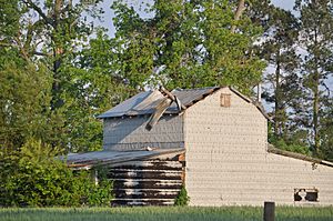
Tornado damage near Dunn, NC
|
|
| Max rating1 | EF3 tornado |
| Damage | $141.1 million (2011 USD) |
| Total fatalities | 2 fatalities, 176 injuries |
| 1Most severe tornado damage; see Enhanced Fujita scale | |
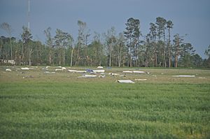
Another strong tornado formed at 3:33 p.m. EDT in Hoke County. It damaged homes and then entered Cumberland County, hitting the northwestern parts of Fayetteville. It also tracked through parts of Fort Bragg and nearby neighborhoods. Many homes and businesses in Fayetteville were destroyed. Most of the damage was EF0 to EF2, but some EF3 damage was seen later.
One person was killed, and at least 85 people were injured in Cumberland County. In Fayetteville, the worst damage was near Fort Bragg, where some EF3 damage occurred. The Goodyear Plant was heavily damaged. Womack Army Medical Center had to use backup power. This tornado was up to a mile wide. It destroyed 150 houses in northwest Fayetteville and damaged many more.
Several houses were destroyed between Spring Lake and Linden. The storm grew into a large "wedge tornado" that drivers saw along Interstate 95. This storm caused EF2 damage as it tracked through Dunn and south of Benson. Television footage showed it was a wide tornado with multiple smaller funnels spinning inside it. A Food Lion warehouse and a trailer park in Dunn were severely damaged. Two people were killed by this tornado: one in Cumberland County and one in Dunn. Many people were injured in Harnett and Johnston counties.
In Johnston County, highways, including Interstate 95, were blocked for a short time by debris. The tornado finally ended at 4:45 p.m. EDT after traveling about 58.5 miles (94.1 km). Damage in Johnston County reached $25 million, with 450 homes damaged and 287 completely destroyed. The same supercell storm produced more tornadoes in Johnston and Wilson counties later.
Askewville / Bertie County, North Carolina Tornado
| EF3 tornado | |
|---|---|
| Max rating1 | EF3 tornado |
| Damage | $4.45 million (2011 USD) |
| Total fatalities | 12 fatalities, 58 injuries |
| 1Most severe tornado damage; see Enhanced Fujita scale | |
Around 6:55 p.m. EDT on April 16, a strong tornado touched down south of Askewville, North Carolina. This tornado traveled northeast for about 17.88 miles (28.78 km). At times, it was up to ½ to ¾ miles wide. It lifted about three miles east of Harrellsville, North Carolina.
Officials in Bertie County reported huge damage in the Askewville area. 67 homes and 37 mobile homes were destroyed, with some homes ripped right off their foundations. One business was also destroyed, and many other buildings were damaged. The tornado destroyed seven mobile homes at Jake's Trailer Park, injuring two people.
This long-lasting tornado was the deadliest of the entire outbreak. It killed 11 people, including a family of three and another couple, when it hit areas west of Colerain. It also injured 58 people along its path. On April 20, one of the injured people died, bringing the death toll from this tornado to 12. The tornado moved into Hertford County, damaging and destroying more homes before it ended at 7:10 p.m. EDT. Another tornado, rated EF2, touched down nearby and traveled parallel to this one.
Bertie County had also been hit by strong tornadoes in 1984 and 1943.
Other Weather Events
Besides the tornadoes, a late-season blizzard also happened. This was a snowstorm with strong winds and heavy snow, up to 16 inches (40 cm) in some places. It hit western Kansas, Nebraska, and parts of South Dakota. Major highways were closed, and travelers were stuck. Heavy snow and some freezing rain also fell in parts of the Upper Midwest, like Minnesota and Wisconsin.
In the Northeastern United States, there were very strong winds, sometimes gusting over 70 mph (110 km/h), especially in northern New York state.
What Happened After
After the tornadoes ended, many communities were left devastated. There was a lot of destruction, and many places had no electricity. Major cities like Raleigh, Little Rock, and Jackson were affected.
Because of the widespread damage, the governors of Alabama and North Carolina declared a "state of emergency" for their entire states. 26 counties in Oklahoma and 14 counties in Mississippi were also put under a state of emergency. In total, the tornadoes killed 38 people, injured many more, and caused at least $600 million in damage.
Comparing to Other Outbreaks
This tornado outbreak was the deadliest in the United States since the 2008 Super Tuesday tornado outbreak in 2008, which killed 57 people. In North Carolina, it was the biggest outbreak since March 1984. A meteorologist named Henry Margusity said that there had never been a three-day tornado outbreak with so many tornadoes from a single storm system. However, this record was broken just over a week later by the 2011 Super Outbreak.
Tornado events this big are rare in North Carolina. Only outbreaks in 1884 and 1984 were similar in size and widespread damage. An outbreak in 1973 had over 25 tornadoes, but most were weaker. The May 1989 outbreak had fewer but stronger storms. More recently, an outbreak in May 1998 had 18 tornadoes, including one F4 and one F3, but other storms were much weaker.
See also
 In Spanish: Oleada de tornados en Estados Unidos del 14-16 de abril de 2011 para niños
 | Emma Amos |
 | Edward Mitchell Bannister |
 | Larry D. Alexander |
 | Ernie Barnes |


