
Twenty Mile Creek (Ontario) facts for kids
The Twenty Mile Creek is a small river in the Niagara Peninsula, Ontario, Canada. It gets its name because its mouth (where it flows into a larger body of water) is about twenty miles (32 km) west of the Niagara River along the Lake Ontario shoreline. The original name for the Twenty Mile Creek, given by the Indigenous people, was Kenachdaw, which means "Lead River."
Quick facts for kids Twenty Mile Creek |
|
|---|---|

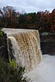
The Twenty Mile Creek flows over Ball's Falls as it crosses the Niagara Escarpment
|
|

Location of the mouth of the Twenty Mile Creek in southern Ontario
|
|
| Native name | Kenachdaw |
| Country | Canada |
| Province | Ontario |
| Region | Southern Ontario |
| Regional Municipality | Niagara |
| Physical characteristics | |
| Main source | Headwaters south of the City of Hamilton, near Hamilton International Airport 238 m (781 ft) 43°11′7″N 79°54′34″W / 43.18528°N 79.90944°W |
| River mouth | Lake Ontario Jordan Harbor 74 m (243 ft) 43°09′28″N 79°22′19″W / 43.15778°N 79.37194°W |
| Length | 79 km (49 mi) |
| Basin features | |
| River system | Great Lakes Basin |
| Basin size | 291 km2 (112 sq mi) |
| Tributaries |
|
Contents
What is the Twenty Mile Creek Watershed?
A watershed is an area of land where all the water drains into a single river or lake. The Twenty Mile Creek watershed covers about 290 square kilometers (112 square miles). It stretches for about 79 kilometers (49 miles).
Where does the creek start and end?
The creek begins in the hills south of the city of Hamilton, near the Hamilton International Airport. From there, it flows east before turning north. It then crosses the Niagara Escarpment at Ball's Falls, where it drops about 25 meters (83 feet). The creek eventually flows into Lake Ontario at Jordan Harbour. This area includes the Jordan Marsh, which formed when lake waters flooded the lower parts of the river valley.
What are the smaller streams in the watershed?
The Twenty Mile Creek watershed has five smaller sections, each with its own stream. These include the main Twenty Mile Creek channel, Gavora Ditch, Spring Creek, North Creek, and Sinkhole Creek.
What kind of land is in the watershed?
The upper parts of the Twenty Mile Creek watershed have rolling hills and fairly steep slopes. Further downstream, the land becomes gently rolling or flat before the creek goes over the Niagara Escarpment.
Why does the creek sometimes dry up?
During the summer months, the water flow in Twenty Mile Creek can become very low or even stop completely. However, some water stays in the deeper pools. This low water level might be due to changes in how the land is used, especially because of farming. For example, there are fewer forests, which means less water is stored in the ground. Also, compacted soil and drainage systems can affect the water flow. Sometimes, water can also disappear into cracks in the bedrock or into underground cave systems.
Can you travel on Twenty Mile Creek?
In the past, small boats and canoes could travel up the Twenty Mile Creek as far as Smithville. People had to carry their boats around waterfalls, especially at Ball's Falls. Today, people still enjoy rafting, kayaking, and canoeing on the rapids both above and below Ball's Falls. The main waterfall at Ball's Falls, which is 25 meters (83 feet) high, has not been attempted by boaters. The rapids on the creek range from Class II to Class V, depending on how high the water is. This means some parts are easy, while others are very difficult and only for experienced paddlers.
How did the creek help towns grow?
The Twenty Mile Creek was very important for the early growth of towns along its banks. Places like Smithville, St. Anns, and Jordan all developed because of industries that used the creek's water power. The old ghost town of Ball's Falls also grew because of its location on the Twenty Mile Creek.
Images for kids
-
The Twenty Mile Creek flows over Ball's Falls as it crosses the Niagara Escarpment
