Umbagog Lake facts for kids
Quick facts for kids Umbagog Lake |
|
|---|---|
 |
|
| Location | Coös County, New Hampshire; Oxford County, Maine |
| Coordinates | 44°45′25″N 71°2′57″W / 44.75694°N 71.04917°W |
| Primary inflows | Magalloway River Rapid River Dead Cambridge River |
| Primary outflows | Androscoggin River |
| Basin countries | United States |
| Max. length | 10.4 miles (16.7 km) |
| Max. width | 1.9 miles (3.1 km) |
| Surface area | 7,850 acres (31.8 km2) |
| Average depth | 10 feet (3 m) |
| Max. depth | 45 feet (14 m) |
| Surface elevation | 1,245 feet (379 m) |
| Islands | Big Island; Blake Island; Bear Island; Metallak Island; Blueberry Island; "C" Island; Pine Island; Mosquito Island; Absalom Island; Black Island |
| Settlements | Errol, New Hampshire; Upton, Maine |
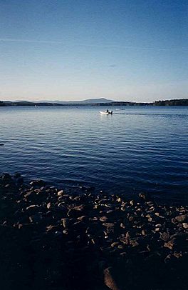
Umbagog Lake is a beautiful wilderness lake located in the states of New Hampshire and Maine. It is known for being one of the most natural and untouched lakes in New Hampshire. The lake is found near the towns of Errol, New Hampshire, and Upton, Maine.
The name Umbagog is pronounced "um-BAY-gog". It comes from the Abenaki people, who are Native Americans. The word means "shallow water," which describes parts of the lake. You can call it "Lake Umbagog" or "Umbagog Lake"—both names are correct.
Contents
Exploring Umbagog Lake
Umbagog Lake is a special place for nature lovers. It is part of the Umbagog National Wildlife Refuge and Umbagog Lake State Park. These areas help protect the lake and its wildlife.
Visiting the Lake
If you want to visit, there is a public campground on the south side of the lake. You can also find a boat launch ramp there. These spots are easy to reach from New Hampshire Route 26.
There are also 33 special campsites around the lake. You can only get to these campsites by boat. This makes them perfect for a true wilderness adventure!
Unique Features of the Lake
One interesting thing about Umbagog Lake is a large floating island. It is located on the northwest side of the lake. This island is made of many layers of old marsh plants that have broken down over time. It actually floats on the water!
The lake is about 11 miles (18 km) long from north to south. It covers an area of 7,850 acres (31.8 km2). This makes it the biggest lake right on the border between Maine and New Hampshire.
The lake is not very deep on average, about 10 feet (3.0 m). But in some spots, it can be as deep as 45 feet (14 m). Long ago, a dam was built at Errol. This dam made the lake bigger and deeper than it used to be.
Water Flow and Fish
Umbagog Lake gets its water from three main rivers: the Magalloway River, the Rapid River, and the Dead Cambridge River. The lake is also the start of the Androscoggin River, which flows out of it.
Fish Species
The lake is a good place for fishing. It is known as a warmwater fishery. This means it has fish that prefer warmer water. Some of the fish you might find here include smallmouth bass, chain pickerel, horned pout, and northern pike.
Wildlife Around the Lake
The area around Umbagog Lake is full of amazing wildlife. Many different animals live here because of the protected natural environment.
You might see animals like coyotes, wild turkeys, and moose. There are also smaller animals like rabbits.
Birds of Umbagog Lake
The lake is a great place for birdwatching. You can often spot majestic birds like bald eagles and ospreys. These birds are known for their fishing skills. You might also hear the unique calls of loons on the water.
Other Animals
Other animals that call this wilderness home include bobcats and black bears. The lake's natural setting provides a safe habitat for all these creatures.
 | May Edward Chinn |
 | Rebecca Cole |
 | Alexa Canady |
 | Dorothy Lavinia Brown |


