Union Star, Missouri facts for kids
Quick facts for kids
Union Star, Missouri
|
|
|---|---|

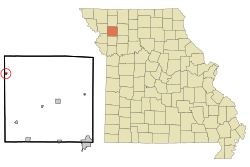
Location of Union Star, Missouri
|
|
| Country | United States |
| State | Missouri |
| County | DeKalb |
| Area | |
| • Total | 0.26 sq mi (0.68 km2) |
| • Land | 0.26 sq mi (0.68 km2) |
| • Water | 0.00 sq mi (0.00 km2) |
| Elevation | 971 ft (296 m) |
| Population
(2020)
|
|
| • Total | 380 |
| • Density | 1,450.38/sq mi (560.30/km2) |
| Time zone | UTC-6 (Central (CST)) |
| • Summer (DST) | UTC-5 (CDT) |
| ZIP code |
64494
|
| Area code(s) | 816 |
| FIPS code | 29-75130 |
| GNIS feature ID | 2397704 |
Union Star is a small city located in the northwest part of DeKalb County, Missouri, in the United States. It sits near the Third Fork of the Platte River. In 2020, about 380 people lived there. Union Star is also part of the larger St. Joseph Metropolitan Area, which includes nearby cities in Missouri and Kansas.
Contents
History of Union Star
A post office has been open in Union Star since 1863. The city's name, "Union Star," likely came from the fact that many local residents supported the "Union" side during the American Civil War.
Geography and Location
Union Star is found in the Polk township of DeKalb County. It is right on the border with Andrew County. The city is about 20 miles (32 km) away from Saint Joseph. You can reach Union Star by taking U.S. Highway 169, which is close to Exit 50 on Interstate 29.
According to the United States Census Bureau, Union Star covers a total area of about 0.26 square miles (0.68 square kilometers). All of this area is land, with no water.
Population and People
| Historical population | |||
|---|---|---|---|
| Census | Pop. | %± | |
| 1880 | 72 | — | |
| 1890 | 272 | 277.8% | |
| 1900 | 439 | 61.4% | |
| 1910 | 388 | −11.6% | |
| 1920 | 434 | 11.9% | |
| 1930 | 414 | −4.6% | |
| 1940 | 411 | −0.7% | |
| 1950 | 373 | −9.2% | |
| 1960 | 392 | 5.1% | |
| 1970 | 417 | 6.4% | |
| 1980 | 423 | 1.4% | |
| 1990 | 432 | 2.1% | |
| 2000 | 433 | 0.2% | |
| 2010 | 437 | 0.9% | |
| 2020 | 380 | −13.0% | |
| U.S. Decennial Census | |||
Union Star Population in 2010
In 2010, a special count of the population, called a census, showed that 437 people lived in Union Star. There were 175 households, which are groups of people living together in one home. Out of these, 123 were families.
The city had about 1,681 people per square mile (649 people per square kilometer). There were 203 housing units, which are places where people can live.
Most of the people in Union Star were White (98.2%). A small number were Asian (0.2%), and 1.6% were from two or more racial backgrounds. About 0.2% of the population identified as Hispanic or Latino.
- About 33.1% of households had children under 18 living with them.
- 54.9% were married couples living together.
- 10.9% had a female head of the household with no husband present.
- 4.6% had a male head of the household with no wife present.
- 29.7% were not families, meaning they were individuals or unrelated people living together.
- 27.4% of all households were made up of just one person.
- 17.1% had someone living alone who was 65 years old or older.
The average household had 2.50 people, and the average family had 2.99 people. The average age of people in the city was 37.6 years old.
- 25.9% of residents were under 18 years old.
- 7.9% were between 18 and 24 years old.
- 24.7% were between 25 and 44 years old.
- 24.7% were between 45 and 64 years old.
- 16.7% were 65 years old or older.
More males lived in Union Star than females, with 52.6% being male and 47.4% being female.
See also
 In Spanish: Union Star (Misuri) para niños
 | Emma Amos |
 | Edward Mitchell Bannister |
 | Larry D. Alexander |
 | Ernie Barnes |

