University Peak (California) facts for kids
Quick facts for kids University Peak |
|
|---|---|

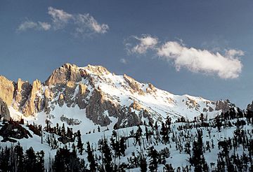
University Peak from the northeast, March 2006.
|
|
| Highest point | |
| Elevation | 13,595 ft (4,144 m) NAVD 88 |
| Prominence | 1,187 ft (362 m) |
| Parent peak | Mount Keith |
| Listing |
|
| Geography | |
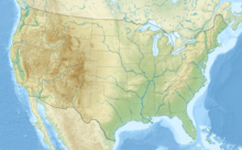
| Location | Inyo / Tulare counties, California, U.S. |
| Parent range | Sierra Nevada |
| Topo map | USGS Mount Williamson |
| Climbing | |
| First ascent | July 12, 1896 by J. N. Le Conte, Helen M. Gompertz, Belle J. Miller, Estelle Miller |
| Easiest route | South Slopes, cross county hike |
University Peak is a tall mountain in the Sierra Nevada mountain range. It's called a "thirteener" because it's over 13,000 feet high! This peak got its name from the University of California.
It sits right on the Sierra crest, with Mount Gould to its north and Mount Bradley to its south. Part of the mountain is in Tulare County, and another part is in Inyo County. The west side of University Peak is inside Kings Canyon National Park. Its east side is part of the John Muir Wilderness.
Climbing University Peak
If you want to visit University Peak, the closest starting point is a place called Onion Valley. This is where many trails begin.
The easiest way to reach the top is by hiking up its south slopes. This path doesn't follow a marked trail. It's more of an off-trail adventure.
There are also many other ways to climb the peak. Some routes are easy scrambles, which means climbing over rocks using your hands. Other routes are more challenging rock climbing paths. Because of these harder routes, the Sierra Club lists University Peak as a "Mountaineers Peak." This means it's a mountain that experienced climbers enjoy.
First Ascent
The first time people successfully climbed University Peak was on July 12, 1896. A group of four climbers made it to the top. They were J. N. Le Conte, Helen M. Gompertz, Belle J. Miller, and Estelle Miller.
 | Anna J. Cooper |
 | Mary McLeod Bethune |
 | Lillie Mae Bradford |


