Upham, Wisconsin facts for kids
Quick facts for kids
Upham, Wisconsin
|
|
|---|---|

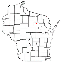
Location of Upham, Wisconsin
|
|
| Country | |
| State | |
| County | Langlade |
| Area | |
| • Total | 73.9 sq mi (191.4 km2) |
| • Land | 70.3 sq mi (182.1 km2) |
| • Water | 3.6 sq mi (9.3 km2) |
| Elevation | 1,677 ft (511 m) |
| Population
(2010)
|
|
| • Total | 676 |
| • Density | 10/sq mi (3.7/km2) |
| Time zone | UTC-6 (Central (CST)) |
| • Summer (DST) | UTC-5 (CDT) |
| ZIP Codes |
54424 (Deerbrook)
54485 (Summit Lake) |
| Area code(s) | 715 & 534 |
| FIPS code | 55-81950 |
| GNIS feature ID | 1584321 |
Upham is a small town located in Langlade County, Wisconsin, in the United States. In 2010, about 676 people lived there. A "town" in Wisconsin is a type of local government area, similar to a township in other states. The smaller communities of Koepenick and Summit Lake are also part of Upham.
Contents
History of Upham
How Upham Got Its Name
The town of Upham was named after William H. Upham. He was a very important person in Wisconsin's history. William H. Upham served as the Governor of Wisconsin. This means he was the leader of the state government.
Geography of Upham
Where is Upham Located?
Upham is found in the north-central part of Langlade County. This county is in the state of Wisconsin. A major road, U.S. Route 45, goes through the town. This road connects Upham to other places.
Nearby Cities and Lakes
If you travel south on U.S. Route 45, you will reach Antigo. Antigo is about 15 miles away. It is also the main city and county seat for Langlade County. Going north on the same road, you will find Monico, which is about 18 miles away.
The main community in Upham is called Summit Lake. It is located near the northern border of the town. Summit Lake is named after the lake it sits on. There are many other lakes in the area too. Some of the biggest ones include Greater Bass Lake, Clear Lake, and Deep Wood Lake.
Land and Water Area
The United States Census Bureau measures the size of places. They found that Upham covers a total area of about 191.4 square kilometers. Most of this area is land, which is about 182.1 square kilometers. The rest is water, making up about 9.3 square kilometers. This means that nearly 5% of Upham's total area is covered by water.
Population and People of Upham
Who Lives in Upham?
In the year 2000, a census was taken. This count showed that 689 people lived in Upham. These people lived in 319 different homes, called households. About 220 of these households were families. The town had about 9.8 people living in each square mile.
Most of the people in Upham were White. A small number were Native American. Some people identified with two or more races. A very small percentage of the population was Hispanic or Latino.
Family Life and Age Groups
About 18.8% of the homes in Upham had children under 18 living there. Most homes, about 60.8%, were married couples living together. Some homes had a female head of household without a husband. About 31% of homes were not families.
The average home had about 2.16 people. The average family had about 2.59 people. The population of Upham included people of all ages. About 15.8% were under 18 years old. About 21.5% were 65 years old or older. The average age of people in Upham was 50 years old.
Income and Economy
In 2000, the average income for a household in Upham was $36,786 per year. For families, the average income was $41,406 per year. Men generally earned more than women. The average income per person in the town was $20,498.
A small number of families, about 3.8%, lived below the poverty line. This means they had very low incomes. About 4.5% of the total population was also below the poverty line. This included some children under 18 and a very small number of people aged 65 or older.
See also
In Spanish: Upham (Wisconsin) para niños
 | Emma Amos |
 | Edward Mitchell Bannister |
 | Larry D. Alexander |
 | Ernie Barnes |

