Valliant, Oklahoma facts for kids
Quick facts for kids
Valliant, Oklahoma
|
|
|---|---|

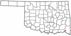
Location of Valliant, Oklahoma
|
|
| Country | United States |
| State | Oklahoma |
| County | McCurtain |
| Area | |
| • Total | 1.94 sq mi (5.01 km2) |
| • Land | 1.93 sq mi (5.00 km2) |
| • Water | 0.01 sq mi (0.02 km2) |
| Elevation | 525 ft (160 m) |
| Population
(2020)
|
|
| • Total | 819 |
| • Density | 424.57/sq mi (163.91/km2) |
| Time zone | UTC-6 (Central (CST)) |
| • Summer (DST) | UTC-5 (CDT) |
| ZIP code |
74764
|
| Area code(s) | 580 |
| FIPS code | 40-76650 |
| GNIS feature ID | 2413421 |
| Website | Chamber of Commerce, Valliant |
Valliant is a small town located in McCurtain County, Oklahoma, in the United States. According to the 2020 census, about 819 people lived there.
Contents
A Look at Valliant's Past
Valliant was started on June 2, 1902. It was named after Frank W. Valliant. He was an engineer working on the Arkansas and Choctaw Railway at the time. When it was founded, Valliant was part of the Choctaw Nation, in an area called Indian Territory. This territory was home to many Native American tribes.
Early Businesses and Growth
In 1903, a cotton gin opened in Valliant. A cotton gin is a machine that separates cotton fibers from their seeds. This gin helped the town's economy until the 1930s. In 1904, Valliant officially became a town and elected its first mayor. A local newspaper started in 1905. Before 1920, Valliant had two banks, three hotels, and almost 20 other businesses. This shows the town was growing quickly.
The Timber Industry
Dierks Forests, Inc. was a big company that harvested and processed timber. They started their work in 1903 near Valliant. The company grew to own a huge amount of forest land. It became one of the largest family-owned land companies in the U.S. In 1969, a larger company called Weyerhaeuser Company bought Dierks Forests.
Pine Creek Lake and Wildlife
In the 1960s, the Pine Creek Dam was built nearby. This dam helps control flooding in the area. It also created Pine Creek Lake. The lake and the Pine Creek Wildlife Management Area are just north of Valliant. These places are popular for vacationers who enjoy nature and outdoor activities.
Where is Valliant Located?
Valliant is in the southwestern part of McCurtain County. It is located along U.S. Route 70. The town is about 3 miles (4.8 km) from the border of Choctaw County. It is also about 6 miles (9.7 km) north of the Red River. The Red River forms the border between Oklahoma and Texas. The town of Idabel is about 15 miles (24 km) southeast of Valliant on Route 70.
According to the United States Census Bureau, Valliant covers a total area of about 0.8 square miles (2.1 square kilometers). All of this area is land.
People Living in Valliant
| Historical population | |||
|---|---|---|---|
| Census | Pop. | %± | |
| 1910 | 656 | — | |
| 1920 | 809 | 23.3% | |
| 1930 | 608 | −24.8% | |
| 1940 | 551 | −9.4% | |
| 1950 | 661 | 20.0% | |
| 1960 | 477 | −27.8% | |
| 1970 | 840 | 76.1% | |
| 1980 | 927 | 10.4% | |
| 1990 | 873 | −5.8% | |
| 2000 | 769 | −11.9% | |
| 2010 | 754 | −2.0% | |
| 2020 | 819 | 8.6% | |
| U.S. Decennial Census | |||
In 2000, the census showed that 771 people lived in Valliant. There were 315 households, and 194 of these were families. The town had about 1,024 people per square mile (395 per square kilometer).
Most people in Valliant identified as White (75.49%). There were also African American (9.21%) and Native American (10.77%) residents. Some people were from other races or from two or more races. A small number of people (0.91%) were Hispanic or Latino.
About 31.4% of households had children under 18 living with them. The average household had 2.30 people, and the average family had 3.00 people. The median age of people in Valliant was 39 years old.
Valliant's Economy
For a long time, Valliant's economy was based on agriculture. Farmers grew crops like cotton and grains. After 1930, cotton farming became less common. So, the land was used for pastures and growing food for cattle.
In the 1970s, forest products became very important. The Weyerhaeuser Company, which makes paper products, opened a paperboard plant and a paper mill in Valliant. This made Weyerhaeuser the largest employer in the town, providing many jobs.
Getting Around Valliant
Valliant is served by US Route 70. It also has Old State Highway 98, which was the original path of the current Oklahoma State Highway 98.
The town is an important spot for trains. Several railroads, including the Texas, Oklahoma and Eastern Railroad, Kiamichi Railroad, and WFEC Railroad, connect and exchange goods here.
The McCurtain County Regional Airport (FAA ID: 4o4) is about 17 miles (27 km) southeast of Valliant. It has a paved runway that is 5002 feet (1525 meters) long. If you need to fly on a commercial airline, the nearest option is Texarkana Regional Airport, which is about 92 miles (148 km) southeast.
See also
 In Spanish: Valliant (Oklahoma) para niños

