Vermillion River (South Dakota) facts for kids
Quick facts for kids Vermillion River |
|
|---|---|

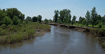
Vermillion River between Parker and Chancellor
|
|

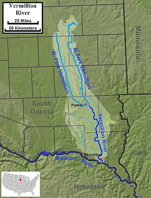
The course and watershed of the Vermillion River.
|
|
| Country | United States |
| State | South Dakota |
| Cities | Vermillion, SD, Centerville, SD |
| Physical characteristics | |
| Main source | Confluence of the East Fork Vermillion River and West Fork Vermillion River Parker Township in Turner County, near Parker, South Dakota 43°23′39″N 97°04′08″W / 43.394083°N 97.069006°W |
| River mouth | Missouri River Fairview Township in Clay County, near Vermillion, South Dakota 42°43′59″N 96°53′25″W / 42.733007°N 96.890335°W |
| Length | 96 mi (154 km) |
| Basin features | |
| Basin size | 2,180 sq mi (5,600 km2) |
The Vermillion River is a cool river in eastern South Dakota, United States. It flows for about 96 miles (154 km). This river is a tributary of the Missouri River. A tributary is a smaller river or stream that flows into a larger river.
The name "Vermillion" comes from the Lakota language. The Lakota people called it Waséoyuze. This means "place where Vermilion is obtained." Vermilion is a bright red color.
Contents
Where Does the Vermillion River Start?
The Vermillion River actually begins when two smaller rivers meet. These are called the East Fork Vermillion River and the West Fork Vermillion River.
East Fork's Journey
The East Fork is about 103 miles long. It starts in Lake Whitewood in Kingsbury County. This area is part of the Coteau des Prairies, which is a high, hilly land.
West Fork's Journey
The West Fork is a bit longer, about 108 miles. It begins in Miner County.
Meeting Point
Both the East and West Forks flow south. They run mostly side-by-side until they join together. This meeting point is east of a town called Parker. After they combine, the river continues flowing south.
Where Does the Vermillion River End?
The combined Vermillion River flows into the mighty Missouri River. This happens about 5 miles south of the town of Vermillion. The river joins the Missouri east of an area known as the James River Highlands.
What Area Does the River Drain?
The Vermillion River helps drain a large area of land. This area is called its watershed or basin. The Vermillion River's watershed covers about 2,180 square miles. This includes the southwestern edge of the Coteau des Prairies.
Smaller Streams Joining In
Other smaller streams also flow into the Vermillion River. These are its tributaries. Some of these include White Stone Creek and Baptist Creek.
How Does the River Compare to Others?
The Vermillion River flows from north to south. It is located between two other important rivers in the Dakotas. To its east is the Big Sioux River. To its west is the James River.
Interesting Fact About the River
Sometimes, the Vermillion River can dry up! This happens about once every 3.5 years. It means the river's water level gets so low that parts of it become completely dry.
 | Jessica Watkins |
 | Robert Henry Lawrence Jr. |
 | Mae Jemison |
 | Sian Proctor |
 | Guion Bluford |


