Vernon Islands facts for kids
|
Native name:
Potinga Islands
|
|
|---|---|

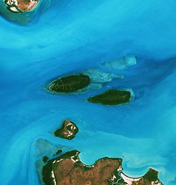
Satellite image of the Vernon Islands, 2019
|
|
| Etymology | Edward Venables-Vernon-Harcourt |
| Geography | |
| Location | Clarence Strait |
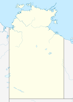
| Coordinates | 12°05′00″S 131°02′00″E / 12.0833°S 131.0333°E |
| Adjacent bodies of water | Clarence Strait |
| Total islands | 3 |
| Major islands | East Vernon Island North West Vernon Island South West Vernon Island |
| Highest elevation | 4 m (13 ft) |
| Administration | |
| Territory | Northern Territory |
| Locality | Vernon Islands |
| Demographics | |
| Population | 0 (2016) |
The Vernon Islands, also called the Potinga Islands, are a group of three islands in the Northern Territory of Australia. They are located in the Clarence Strait, about 55 kilometers (34 miles) north-east of Darwin, the capital city of the Northern Territory.
These islands were first seen by Europeans in 1818. This happened when a British navy ship, led by Phillip Parker King, sailed by. The islands are very important to the Tiwi people, an Aboriginal group. After 40 years, in 2018, the Tiwi people officially gained ownership of the islands.
All three islands have special lights and signals called navigation aids. These help ships travel safely through the Clarence Strait. Since 1974, the islands and some nearby ocean areas have been protected. This protected area is known as the Vernon Islands Conservation Reserve. Since 2007, the islands have been part of a place called Vernon Islands.
Contents
About the Vernon Islands
The Vernon Islands are found in the Northern Territory of Australia. They are in the southern part of the Clarence Strait, which is a body of water. The islands are about 55 kilometers (34 miles) north-east of Darwin.
There are three islands in the group: East Vernon Island, North West Vernon Island, and South West Vernon Island. These islands are made of coral. Each island is surrounded by a coral reef. These reefs are completely covered by water when the tide is high.
Ships can travel through the Clarence Strait around the Vernon Islands. There are three main paths: the North Channel, the South Channel, and the Howard Channel. The Howard Channel goes right through the middle of the island group. It separates South West Vernon Island from the other two islands.
Plants and Animals of the Islands
The Vernon Islands are home to interesting plants and animals.
Island Plants
East Vernon Island and North West Vernon Island are covered with mangrove trees. Mangroves are special trees that grow in salty water along coastlines. South West Vernon Island has regular land trees in its center. It also has mangroves along its coast.
The trees on all the islands can grow quite tall. They reach heights between 18 and 21 meters (59 to 69 feet). In the areas where the land meets the sea, you can find seagrass and special types of algae.
Island Animals
The area around the Vernon Islands where the tide goes in and out is very important. It is known as a significant place for coral reefs. This area is also a home for turtles and dugongs. Dugongs are large, gentle sea mammals, sometimes called "sea cows."
Island History
The Vernon Islands have a rich history, especially for the Aboriginal people of Australia.
Aboriginal Connections
The Vernon Islands are very important to the culture and beliefs of several Aboriginal groups. These include the Tiwi Islanders, the Larrakia, and the Wulna people.
The Tiwi Islanders believe that their home, the Tiwi Islands, and the nearby waters, including the Clarence Strait, were created by their ancestor, Mudunkala. In the past, Tiwi Islanders used the Vernon Islands for hunting. They hunted dugongs and turtles there. The islands also served as a stopping point for their journeys to the mainland.
In 1978, a land claim was made for the island group. This claim was under a law called the Aboriginal Land Rights (Northern Territory) Act 1976. After many years, the claim was settled. In 2015, new laws were passed. On March 12, 2018, the Mantiyupwi Tiwi people officially received ownership of the land.
The Tiwi Land Council is a group that works for the Tiwi Islanders. In 2013, they suggested watching over the islands' coastlines and nearby waters. They wanted to check for things like unusual plants or animals, trash in the ocean, and how many visitors came to the islands.
The Tiwi Land Council allows fishing for fun in the areas around the islands where the tide changes. However, if you want to visit any of the three islands, you need to get a special permit first.
The Tiwi Islanders have their own names for the islands. They call the whole group the Potinga Islands. Southwest Vernon Island is called Kulangana. Northwest Vernon Island is Warabatj. And East Vernon Island is Muma.
European Discoveries
The first time Europeans saw the Vernon Islands was in 1818. This happened when the British ship, HMS Mermaid, sailed by. The ship was led by Phillip Parker King. King named the islands after Edward Venables-Vernon-Harcourt. He was an important church leader at the time.
Today, the waters around the Vernon Islands are a popular spot. Many people enjoy fishing and boating there.
Special Navigation aids are placed on the islands. These aids help large ships travel safely. They are located on the western end of North West Vernon Island, the north coast of South West Vernon Island, and the south coast of East Vernon Island. These lights and signals guide ships moving between Beagle Gulf and Van Diemen Gulf.
Protected Area Status
The Vernon Islands and a nearby reef called Knight Reef are protected areas. They were first set aside for protection in 1974. Since 1979, this protected area has been known as the Vernon Islands Conservation Reserve. This means the natural environment is kept safe.
Administrative Status
On April 4, 2007, the Northern Territory Government officially named the area around the Vernon Islands as a "locality." This means it's a recognized place on the map. The area is called Vernon Islands. This locality is not part of any local government area. It is considered part of the Northern Territory's "unincorporated areas." This means it's managed directly by the territory government.
 | Bessie Coleman |
 | Spann Watson |
 | Jill E. Brown |
 | Sherman W. White |


