Vineyard Haven, Massachusetts facts for kids
Quick facts for kids
Vineyard Haven, Massachusetts
|
|
|---|---|

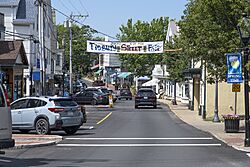
Main Street
|
|

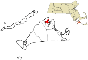
Location in Dukes County in Massachusetts
|
|
| Country | United States |
| State | Massachusetts |
| County | Dukes |
| Area | |
| • Total | 1.31 sq mi (3.40 km2) |
| • Land | 1.30 sq mi (3.38 km2) |
| • Water | 0.01 sq mi (0.02 km2) |
| Elevation | 46 ft (14 m) |
| Population
(2020)
|
|
| • Total | 2,747 |
| • Density | 2,106.60/sq mi (813.23/km2) |
| Time zone | UTC-5 (Eastern (EST)) |
| • Summer (DST) | UTC-4 (EDT) |
| ZIP codes |
02568, 02573
|
| Area code(s) | 508 |
| FIPS code | 25-71970 |
| GNIS feature ID | 0616143 |
Vineyard Haven is a community located on the island of Martha's Vineyard in Massachusetts, United States. It is part of the larger town of Tisbury, Massachusetts. The U.S. Census Bureau calls it a "census-designated place" (CDP). This means it is a special area the government counts for population. In 2020, about 2,747 people lived there.
The native Wampanoag people called this area "Nobnocket." Early settlers named it "Homes Hole." "Homes" came from a Wampanoag word for "old man." "Hole" meant a safe, sheltered inlet for boats. Later, it was often spelled "Holmes Hole." This was after the Holmes family, who settled there in the 1700s. In 1871, the village officially changed its name to Vineyard Haven. While Vineyard Haven is just one part of Tisbury, people often use the name Vineyard Haven for the whole town.
Vineyard Haven is the main entry point to Martha's Vineyard. It is one of the island's three main towns. The others are Edgartown and Oak Bluffs. The Steamship Authority ferry dock is in Vineyard Haven. Ferries arrive and leave from here all year. Another ferry dock is in Oak Bluffs, but it only operates in the summer. About 2,000 people live here year-round. However, many more people visit in the summer months.
Contents
Geography of Vineyard Haven
Vineyard Haven is located at coordinates 41.456109 degrees North and 70.607176 degrees West.
The area of Vineyard Haven is about 4.1 square kilometers (1.6 square miles). Most of this area, about 3.2 square kilometers (1.2 square miles), is land. The rest, about 0.9 square kilometers (0.35 square miles), is water.
Population and People
| Historical population | |||
|---|---|---|---|
| Census | Pop. | %± | |
| 2020 | 2,747 | — | |
| U.S. Decennial Census | |||
In 2000, there were 2,048 people living in Vineyard Haven. There were 941 households, which are groups of people living together. About 23.1% of these households had children under 18.
The population was spread out by age. About 20.6% of people were under 18 years old. About 16.7% were 65 years or older. The average age was 41 years.
Getting Around Vineyard Haven
Air Travel
You can fly to Martha's Vineyard through the Martha's Vineyard Airport. This airport serves the entire island.
Bus Service
The Martha's Vineyard Regional Transit Authority (VTA) provides public transportation. This is the most reliable way to travel around the island from Vineyard Haven. Almost all VTA buses stop at the Vineyard Haven Steamship Authority bus terminal. This terminal is very busy, especially in the summer. The VTA is the only public bus system on Martha's Vineyard. It is a great option for tourists who do not have a car.
See also
 In Spanish: Vineyard Haven (Massachusetts) para niños
 | May Edward Chinn |
 | Rebecca Cole |
 | Alexa Canady |
 | Dorothy Lavinia Brown |


