
Tisbury, Massachusetts facts for kids
Quick facts for kids
Tisbury, Massachusetts
|
|||
|---|---|---|---|

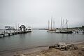
Vineyard Haven Harbor
|
|||
|
|||

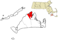
Location in Dukes County in Massachusetts
|
|||
| Country | United States | ||
| State | Massachusetts | ||
| County | Dukes | ||
| Settled | 1660 | ||
| Incorporated | July 8, 1671 | ||
| Government | |||
| • Type | Open town meeting | ||
| Area | |||
| • Total | 19.1 sq mi (49.5 km2) | ||
| • Land | 6.5 sq mi (16.9 km2) | ||
| • Water | 12.6 sq mi (32.6 km2) | ||
| Elevation | 89 ft (27 m) | ||
| Population
(2020)
|
|||
| • Total | 4,815 | ||
| • Density | 738/sq mi (284.9/km2) | ||
| Time zone | UTC-5 (Eastern) | ||
| • Summer (DST) | UTC-4 (Eastern) | ||
| ZIP code |
02568
|
||
| Area code(s) | 508 / 774 | ||
| FIPS code | 25-69940 | ||
| GNIS feature ID | 0619443 | ||


Tisbury is a town located on Martha's Vineyard in Dukes County, Massachusetts, United States. In 2020, about 4,815 people lived there.
The main village in Tisbury is called Vineyard Haven. People often use "Tisbury" and "Vineyard Haven" to mean the same place. Tisbury became an official town in 1671. The port and harbor were once known as "Holmes Hole." Later, this name changed to "Vineyard Haven," which is now the official post office name. Most people on Martha's Vineyard call it Vineyard Haven. However, they know Tisbury is the town's legal name.
Vineyard Haven in Tisbury is the main entry point to Martha's Vineyard. It is the only port on the island that operates almost all year.
Contents
Exploring Tisbury's Past

The Wampanoag people have lived on Martha's Vineyard for thousands of years. They called the island Noepe. The first English explorer, Bartholomew Gosnold, arrived in 1602.
Tisbury was first settled in 1660 by James Allen, William Peabody, and Josiah Standish. Josiah was the son of Captain Myles Standish. The town officially became a town in 1671. This was done by Francis Lovelace, who was the Governor General of New York at the time.
The town was named after Tisbury, Wiltshire, England. This was the hometown of Martha's Vineyard Governor Mayhew. Later, the island became part of Massachusetts in 1673. This happened after people on the island asked for a change in leadership.
In 1892, the town's boundaries were set to what they are today.
Tisbury and the Sea
Tisbury has always been important for sea travel. Today, it is home to the main ferry docks for Martha's Vineyard. The main ferry service is the Steamship Authority. It connects the island to Woods Hole, New Bedford, and Nantucket in Massachusetts. During the summer, ferries also run from the Oak Bluffs terminal.
Other private ferry lines also serve Martha's Vineyard. Their terminals are in Oak Bluffs and Edgartown. If you've seen the movie Jaws, the early scene shows a ferry arriving. This scene was filmed at the Vineyard Haven Steamship Authority. It gives you an idea of how many people and goods arrive in summer.
Like the rest of Martha's Vineyard, Tisbury is a popular summer spot. Many famous people have lived in Tisbury. These include writers and actors like Art Buchwald, William Styron, Lillian Hellman, and Thornton Wilder. Singer Carly Simon and journalist Mike Wallace also lived there.
A character named Flask from Herman Melville's book Moby-Dick is from Tisbury. He was the third mate on the ship Pequod.
Tisbury's Location and Landscape
Tisbury covers about 49.5 square kilometers (19.1 square miles). About 16.9 square kilometers (6.5 square miles) is land. The rest, about 32.6 square kilometers (12.6 square miles), is water. This means a lot of the town is covered by water!
Tisbury is bordered by Vineyard Haven Harbor and Lagoon Pond to the east. Oak Bluffs is also to the east. To the southwest is West Tisbury. To the northwest is Vineyard Sound. Tisbury also shares a corner with Edgartown.
Important areas in Tisbury include Vineyard Haven, Makonikey, Pilot Hill, West Chop, and Lambert's Cove.
Water Features and Landforms
Tisbury is about 3.3 miles (5.3 kilometers) from the mainland of Cape Cod. This is the closest point on Martha's Vineyard to the mainland.
Most of central Tisbury is low and near sea level. Some areas rise to about 150 feet (46 meters) high. West Chop is the northernmost point on Martha's Vineyard. It has a lighthouse called the West Chop Light. The town is also home to Lake Tashmoo, which is just south of West Chop.
Who Lives in Tisbury?
| Historical population | ||
|---|---|---|
| Year | Pop. | ±% |
| 1850 | 1,803 | — |
| 1860 | 1,631 | −9.5% |
| 1870 | 1,536 | −5.8% |
| 1880 | 1,518 | −1.2% |
| 1890 | 1,506 | −0.8% |
| 1900 | 1,149 | −23.7% |
| 1910 | 1,196 | +4.1% |
| 1920 | 1,275 | +6.6% |
| 1930 | 1,541 | +20.9% |
| 1940 | 1,966 | +27.6% |
| 1950 | 1,930 | −1.8% |
| 1960 | 2,169 | +12.4% |
| 1970 | 2,257 | +4.1% |
| 1980 | 2,972 | +31.7% |
| 1990 | 3,120 | +5.0% |
| 2000 | 3,755 | +20.4% |
| 2010 | 3,949 | +5.2% |
| 2020 | 4,815 | +21.9% |
| 2023* | 4,865 | +1.0% |
| * = population estimate. | ||
In 2000, there were 3,755 people living in Tisbury. There were 1,646 households and 902 families. The population density was about 285 people per square kilometer (738 per square mile).
Most people in Tisbury are White (90.04%). There are also African American (2.96%), Native American (1.36%), and Asian (0.32%) residents. Some people are from other races (1.33%) or from two or more races (3.94%). About 1.04% of the population was Hispanic or Latino.
Many white residents have Portuguese family backgrounds. Many "Native Islanders" (people born on the island) have mixed backgrounds. These can include Portuguese, Native American (Wampanoag Indian), and African American families. These families have lived there for many generations. They often worked in fishing, whaling, and preparing whaling ships.
The average household had 2.21 people, and the average family had 2.92 people. About 25.5% of households had children under 18. About 40.9% were married couples living together.
The median age in Tisbury was 42 years old. About 21.5% of the population was under 18. About 17.9% were 65 or older.
The median income for a household in Tisbury was $37,041. For a family, it was $53,051. About 12.2% of the population lived below the poverty line. This included 22.9% of those under 18.
Tisbury is the second most populated town in Dukes County, after Edgartown. It is the most densely populated town in Dukes County.
There's a big difference between the wealth of people who live in Tisbury all year and those who visit in the summer. Year-round residents generally have lower incomes than the Massachusetts average. Summer visitors are often very wealthy.
Learning in Tisbury
Tisbury is part of the Martha's Vineyard Regional School District. This district also includes Aquinnah, Chilmark, Edgartown, Oak Bluffs, and West Tisbury.
Students in Tisbury go to Tisbury Elementary School for grades K-8. After that, high school students attend Martha's Vineyard Regional High School. The high school teams are called the Vineyarders. Their colors are violet and white. They have a long-standing rivalry with Nantucket High School. They compete for the Island Cup every year.
The Tisbury school is the oldest school on the island. It was built in 1929 and has been teaching children for over 80 years. The Tisbury school colors are blue and gold, and their mascot is a tiger.
Tisbury is also home to the Vineyard Montessori School. This school teaches students from pre-kindergarten up to third grade.
Famous People from Tisbury
- Asa B. Carey, a U.S. Army brigadier general
- Katharine Cornell, a famous actress, writer, and theater producer.
- Jim Ferraro, an attorney
- Edmund C. Weeks, a politician from Florida
- Benjamin West, a lawyer from New Hampshire
Images for kids
-
Vineyard Haven Harbor
-

Seal of Tisbury
-

Flag of Tisbury
-
Location in Dukes County in Massachusetts
-
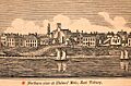
Northern view of Holmes Hole, East Tisbury, 1841
See also
 In Spanish: Tisbury (Massachusetts) para niños
