
Martha's Vineyard Airport facts for kids
Quick facts for kids
Marthas Vineyard Airport
|
|||||||||||||||
|---|---|---|---|---|---|---|---|---|---|---|---|---|---|---|---|
| Summary | |||||||||||||||
| Airport type | Public | ||||||||||||||
| Owner | Dukes County | ||||||||||||||
| Operator | Martha's Vineyard Airport Commission | ||||||||||||||
| Serves | Dukes County, Massachusetts | ||||||||||||||
| Location | Vineyard Haven, Massachusetts | ||||||||||||||
| Focus city for | Cape Air | ||||||||||||||
| Elevation AMSL | 67 ft / 20 m | ||||||||||||||
| Coordinates | 41°23′35″N 070°36′52″W / 41.39306°N 70.61444°W | ||||||||||||||
| Website | MVYairport.com | ||||||||||||||
| Maps | |||||||||||||||
 FAA airport diagram |
|||||||||||||||

MVY
Location in Massachusetts

MVY
Location in the United States
|
|||||||||||||||
| Runway | |||||||||||||||
|
|||||||||||||||
| Statistics (2017) | |||||||||||||||
|
|||||||||||||||
|
Source: Federal Aviation Administration
|
|||||||||||||||
Martha's Vineyard Airport (IATA: MVY, ICAO: KMVY, FAA LID: MVY) is a public airport on the beautiful island of Martha's Vineyard. It's about three miles (5 km) south of Vineyard Haven, in Dukes County, Massachusetts, United States. Dukes County owns this airport. It sits right on the border between the towns of West Tisbury and Edgartown.
This airport is the biggest of three on the island. It's also the only one that has regular flights from airlines. Besides commercial flights, many private planes also use it. The other airports on the island are Katama Airpark and Trade Wind Airport.
The airport's special code, MVY, is often used as a short way to refer to the whole island of Martha's Vineyard, even for things not related to flying!
Contents
About Martha's Vineyard Airport
Martha's Vineyard Airport covers a large area of 688 acres (278 ha). It has two main runways where planes take off and land. One runway, called 6/24, is about 5,504 feet (1,678 meters) long. The other, 15/33, is about 3,297 feet (1,005 meters) long.
In one year (ending March 31, 2017), the airport had 40,555 aircraft operations. This means about 111 planes took off or landed each day! Most of these were general aviation (private planes), followed by air taxi (small charter flights), and then commercial flights. In November 2017, 72 aircraft were based at this airport. Most were single-engine planes, with some multi-engine planes and one helicopter.
Airport Building and Services
The main airport building, called the terminal, has a restaurant where you can grab a bite. It also has waiting areas for passengers, desks where you check in for your flight, and a small area to pick up your luggage.
Outside, the ramp area can hold up to 50 aircraft. About 15 of these spots are for commercial planes. The air traffic control tower is open from 6:00 AM to 10:00 PM. Air traffic controllers help guide planes safely.
Airport Safety and Security
The West Tisbury Police Department and the Transportation Security Administration (TSA) work together to keep the airport safe and secure. The airport also has its own special firefighting team, called ARFF (Aircraft Rescue and Firefighting). This team has 10 full-time firefighters and several emergency vehicles ready to respond quickly if needed.
History of the Airport
The airport was first built in 1942 during World War II. It was called Naval Auxiliary Air Facility Martha's Vineyard. Its main job was to help train Navy pilots before they went to fight in the war. Thousands of men learned to fly here.
After the war, in 1959, the airport was given to Dukes County. Since then, it has been a public airport.
Many different airlines have served Martha's Vineyard over the years. Northeast Airlines started flying here in 1944. Later, airlines like Air New England and Provincetown-Boston Airline (PBA) also offered flights. In the 1980s, Business Express Airlines flew here as Delta Connection.
The current terminal building was built in 2001. It replaced an older wooden building. If you visit, you can see historical photos and items on the western wall of the main hall. They tell the story of the Navy squadrons that were based there during the war.
Airlines and Places You Can Fly To
Many airlines fly to Martha's Vineyard Airport, especially during certain times of the year.
| Airlines | Destinations |
|---|---|
| American Eagle | Seasonal: Charlotte, New York–LaGuardia, Philadelphia, Washington–National |
| Cape Air | Boston, Nantucket, New Bedford Seasonal: Hyannis, New York–JFK, White Plains |
| Delta Connection | Seasonal: New York-JFK (resumes May 28, 2021), New York–LaGuardia |
| JetBlue | Seasonal: Boston, Newark (begins July 1, 2021), New York–JFK, New York-LaGuardia (begins July 1, 2021), Washington–National |
| Tradewind Aviation | Seasonal charter: Teterboro, White Plains |
Some flights are "seasonal," which means they only happen during certain times of the year, like summer, when more people visit the island.
| Domestic destinations map |
|---|
Popular Flight Routes
Here are the busiest flight routes from Martha's Vineyard Airport, based on passenger numbers from May 2019 to April 2020:
| Rank | Airport | Passengers | Carriers |
|---|---|---|---|
| 1 | Boston, Massachusetts | 19,410 | Cape Air, JetBlue |
| 2 | New York–JFK, New York | 15,270 | Cape Air, JetBlue |
| 3 | New York–LaGuardia, New York | 6,920 | American Eagle, Delta Connection |
| 4 | Washington–National, D.C. | 6,160 | American Eagle, JetBlue |
| 5 | White Plains, New York | 1,750 | Cape Air, Tradewind |
| 6 | Nantucket, Massachusetts | 1,200 | Cape Air |
| 7 | Hyannis, Massachusetts | 450 | Cape Air |
| 8 | New Bedford, Massachusetts | 210 | Cape Air |
- FAA Airport Diagram (PDF), effective 15 December 2011
- Resources for this airport:
- AirNav airport information for KMVY
- ASN accident history for MVY
- FlightAware airport information and live flight tracker
- NOAA/NWS latest weather observations
- SkyVector aeronautical chart for KMVY
- FAA current MVY delay information
Images for kids
-
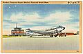
A postcard from the 1940s showing a Northeast DC-3 plane at the airport.
-
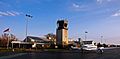
A Cape Air plane on the ramp at Martha's Vineyard Airport in 2001.
-
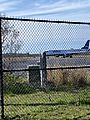
A JetBlue ERJ-190 plane moving towards Gate 2 at MVY.
-
A JetBlue ERJ-190 plane parked at the commercial ramp.
-
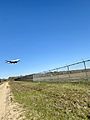
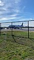
A JetBlue ERJ-190 plane landing at MVY, arriving from Washington-National Airport.
.jpg)


See also
 In Spanish: Aeropuerto de Martha's Vineyard para niños
