
Vredefort impact structure facts for kids
| Vredefort Dome | |

Vredefort Dome (centre), with the Vaal river running across it; seen from space with the Operational Land Imager on Landsat 8, 27 June 2018
|
|
| Impact crater/structure | |
|---|---|
| Confidence | Confirmed |
| Diameter | 300 km (190 mi) |
| Age | 2,023 ± 4 Ma Orosirian, Paleoproterozoic |
| Exposed | Yes |
| Drilled | Yes |
| Location | |
| Coordinates | 27°0′0″S 27°30′0″E / 27.00000°S 27.50000°E |
| Country | South Africa |
| Province | Free State |

Location in South Africa
|
|
| UNESCO World Heritage Site | |
| Official name | Vredefort Dome |
| Includes |
|
| Criteria | Natural: (viii) |
| Inscription | 2005 (29th Session) |
| Area | 30,000 ha (120 sq mi) |
The Vredefort Dome is the biggest known impact crater on Earth. Long ago, a giant space rock crashed here, making a huge crater about 180 to 300 kilometers (110 to 190 miles) wide. Today, what is left of this ancient crash site is in the Free State province of South Africa. It is named after the town of Vredefort, which is close to its center. The middle part of the structure, which pushed up after the impact, is called the Vredefort Dome. This amazing place was formed about 2.023 billion years ago. It is the second-oldest known impact structure on Earth.
In 2005, the Vredefort Dome became a UNESCO World Heritage Site. This means it is a very special place that needs to be protected because of its unique geology.
Contents
How the Vredefort Dome Was Formed


About 2.023 billion years ago, a massive asteroid hit Earth. Scientists believe this asteroid was one of the largest ever to strike our planet. It was probably between 20 and 25 kilometers (12 to 16 miles) wide. It crashed into Earth at an incredible speed, about 15,000 to 25,000 meters per second (34,000 to 56,000 miles per hour).
The crash created a huge crater, estimated to be about 300 kilometers (190 miles) across. Over billions of years, weather and other natural forces have worn away most of this original crater. What we see today, the "Vredefort Dome," is a ring of hills about 70 kilometers (43 miles) wide. This dome formed when the ground beneath the impact site bounced back up after the giant crash. It's like when you drop a heavy ball into soft mud, and the mud splashes up in the middle.
The Vredefort impact is the second-oldest known impact structure on Earth. It is about 10% older than the Sudbury Basin in Canada. Only the Yarrabubba impact crater in Australia is older, by about 200 million years.
At first, people thought the dome in the center was made by a volcano. But in the 1990s, scientists found special rocks called shatter cones in the nearby Vaal River. These rocks only form when something hits the ground with extreme force, proving it was a giant space rock impact.
A Rare Multi-Ringed Structure
The Vredefort impact structure is one of the few places on Earth with more than one ring. This kind of structure is more common on other planets and moons in our Solar System, like the Valhalla crater on Jupiter's moon Callisto. On Earth, most multi-ringed impact structures have been destroyed over time by things like erosion and plate tectonics.
The impact also changed the rocks that were already there. These rocks, like the Witwatersrand Basin, were laid down over millions of years before the impact. The crash pushed these layers of rock into partial circles around the center of the impact site. The oldest rocks, from the Witwatersrand, now form a semicircle about 25 kilometers (16 miles) from the center. These rocks are very hard, so they form the hills you can see today.
The center of the Vredefort Dome, about 40 kilometers (25 miles) wide, is made of very old granite rock. This granite is part of the Kaapvaal craton, one of the oldest pieces of Earth's crust, formed 3.9 billion years ago. This central dome is a common feature in large impact craters. It forms when the ground "splashes" up after the meteor hits.
Protecting the Vredefort Dome
The Vredefort Dome World Heritage Site is a special place, but it faces some challenges. There are concerns about new buildings and waste affecting the Vaal River and the impact structure. Also, some people worry that mining around the edges of the dome could harm this important natural site.
Communities in the Dome
The Vredefort Dome is home to four towns: Parys, Vredefort, Koppies, and Venterskroon. Parys is the largest town and a popular spot for tourists. Vredefort and Koppies mainly rely on farming.
In 2011, a local radio station called Koepel Stereo (Dome Stereo) started broadcasting for the people living in the dome. You can listen to KSFM on 94.9 MHz FM.
Images for kids
-
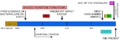
This timeline shows when the Vredefort impact structure was formed. It also shows other important geological events in South Africa. W marks when the Witwatersrand Supergroup formed, C for the Cape Supergroup, and K for the Karoo Supergroup. The graph also shows when banded ironstone formations were made, which tells us the Earth's air had no oxygen then.
-
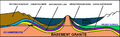
This diagram shows a cross-section of the Vredefort impact structure. It helps us see how the impact changed the layers of rock. Johannesburg is where the yellow layer (Witwatersrand Basin) is exposed on the left, near the original crater edge.
See also
 In Spanish: Cráter de Vredefort para niños
- List of impact craters on Earth
- List of possible impact structures on Earth
