Wabamun 133B facts for kids
Quick facts for kids
Wabamun 133B
|
|
|---|---|
| Country | Canada |
| Province | Alberta |
| Region | Edmonton Metropolitan Region |
| Census division | 11 |
| Area | |
| • Land | 1.94 km2 (0.75 sq mi) |
| Population
(2006)
|
|
| • Total | 20 |
| • Density | 10.3/km2 (27/sq mi) |
| Time zone | UTC−7 (MST) |
| • Summer (DST) | UTC−6 (MDT) |
| Area code(s) | 780, 587, 825, 368 |
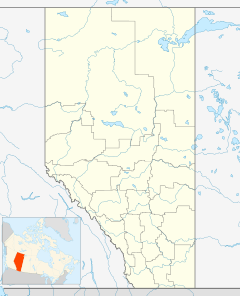
Wabamun 133B is a special area of land in central Alberta, Canada. It is an Indian reserve for First Nations people. This means it is land set aside for the use and benefit of a First Nation group. Wabamun 133B is part of the Paul First Nation.
This reserve is located next to Parkland County. It is also near the east shore of Lake Wabamun. The Summer Village of Kapasiwin is to its west. Another Indian reserve, Wabamun 133A, is to its south.
About Indian Reserves
Indian reserves are special areas of land in Canada. They are set aside by the government for First Nations communities. These lands are for the exclusive use of the First Nations people. They help preserve their culture and way of life.
The Paul First Nation
The Paul First Nation is a group of First Nations people. They are part of the Stoney Nakoda cultural group. Their main reserve is called Wabamun 133. Wabamun 133B is a smaller part of their traditional territory. The Paul First Nation has a Chief and a governing body. They work to manage their lands and support their community.
Population and Land Area
In 2006, Wabamun 133B was home to 20 people. These people lived in 5 different dwellings or homes. The total land area of this Indian reserve is about 1.94 square kilometers. That's about 0.75 square miles.
To understand how many people live in a certain area, we use something called population density. This tells us how crowded an area is. For Wabamun 133B, the population density was about 10.3 people per square kilometer. This means it is not a very crowded place.
 | Kyle Baker |
 | Joseph Yoakum |
 | Laura Wheeler Waring |
 | Henry Ossawa Tanner |


