Wah Wah Valley facts for kids
Quick facts for kids Wah Wah Valley |
|
|---|---|

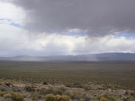
A spring storm hits the Wah Wah Valley,
May 2009 |
|
| Floor elevation | 4,577 feet (1,395 m) |
| Geography | |
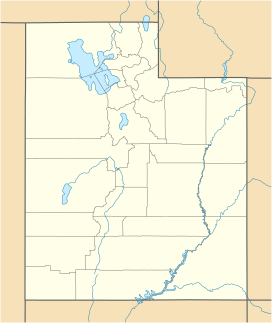
| Location | Beaver and Millard counties, Utah, United States |
| Traversed by | State Route 21 |
The Wah Wah Valley is a unique area located in west-central Utah, United States. It's part of a larger region called the Basin and Range, which has many mountains and valleys. This valley is special because it's an "endorheic basin." This means that any water that flows into the valley stays there and doesn't flow out to the ocean.
About the Valley's Location
The Wah Wah Valley is surrounded by mountains. To the west and south, you'll find the Wah Wah Mountains. To the east, there are the San Francisco Mountains.
In the northern part, the valley splits around the bottom of the House Range. One path leads to Tule Valley in the northwest. The other goes towards the Sevier Desert and the Sevier Lake area in the northeast.
The lowest point in Beaver County is found right at the edge of the Wah Wah Hardpan. This "hardpan" is a dry lake bed, and this low spot is near the border with Millard County.
Why is it Called Wah Wah?
The name 'Wah Wah' comes from the Wah Wah Springs. These springs are located on the eastern side of the Wah Wah Mountain range. People say that 'Wah Wah' means "good clear water." This makes sense, as springs are a source of fresh water in dry areas.
A Look at History
Today, not many people live in the Wah Wah Valley. It's a very quiet place. However, in the past, people did live here. For example, there was a ghost town called Newhouse in the valley.
People first moved to this area for mining. They were looking for valuable minerals in the mountains. Later on, the land was mostly used for grazing. This means that ranchers brought their animals, like cattle or sheep, to eat the plants growing in the valley.
 | Lonnie Johnson |
 | Granville Woods |
 | Lewis Howard Latimer |
 | James West |


