San Francisco Mountains (Utah) facts for kids
Quick facts for kids San Francisco Mountains |
|
|---|---|

|
|
| Highest point | |
| Peak | Frisco Peak |
| Elevation | 9,660 ft (2,940 m) |
| Dimensions | |
| Length | 20 mi (32 km) SW x NE |
| Width | 8 mi (13 km) |
| Geography | |
| Country | United States |
| Communities | Newhouse and Frisco |
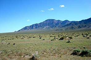
The San Francisco Mountains are a mountain range in Utah, United States. They stretch about 20 miles (32 km) through Beaver and Millard counties. These mountains are part of the larger Great Basin Desert region.
Contents
About the San Francisco Mountains
The San Francisco Mountains are connected to the Cricket Mountains in the northeast. Both ranges follow a similar direction, running from southwest to northeast. They form the eastern edge of the Wah Wah Valley and the usually dry Sevier Lake. This area is in the southwest part of the Sevier Desert.
What Do They Look Like?
The mountain range is long and narrow. It has tall peaks in the southwest. The lower hills in the northeast blend into the Cricket Mountains.
A smaller, rounder group of mountains, called the Beaver Lake Mountains, is attached to the southeast side. The town of Milford is also nearby. The Beaver River flows north through Milford Valley. It then enters the desert area east of these mountains.
Frisco Peak
The highest point in the range is Frisco Peak. It stands 9,660 feet (2,944 meters) tall. This peak is located on a ridge line in the southern part of the mountains.
How Did They Get Their Name?
The San Francisco Mountains got their name a long time ago. It comes from the Domínguez–Escalante expedition of 1776. The name is linked to Saint Francis of Assisi. He was the founder of the Franciscan Order in the Catholic Church. Saint Francis is known as the patron saint of wildlife.
 | Leon Lynch |
 | Milton P. Webster |
 | Ferdinand Smith |


