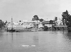
Waiuku facts for kids
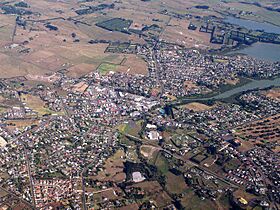
Waiuku is a town in the Auckland Region of New Zealand. It's located at the southern end of the Waiuku River. This river is actually an estuary (where a river meets the sea) that connects to the Manukau Harbour. Waiuku sits on a narrow strip of land on the Āwhitu Peninsula. It's about 40 kilometres southwest of Auckland city centre.
People first settled in the Waiuku area in the 1200s or 1300s. It was a very important place for travel. The Te Pai o Kaiwaka portage (a path for carrying canoes overland) was the best way to travel between the Waikato River and Manukau Harbour. By the 1400s, the area became a main centre for Ngāti Kahukōkā, a Waiohua hapū (sub-tribe). Later, around the 1600s, Ngāti Te Ata formed in Waiuku, combining Waiohua and Waikato Tainui peoples.
Waiuku became a busy trading port in 1851. It helped move goods between the Waikato River and the port of Onehunga. After a conflict in 1863, the port of Waiuku became less busy because fewer Māori goods were being transported. By the late 1800s, Waiuku started to grow as a centre for the dairy industry. A railway line was built to Waiuku in 1922. By 1955, Waiuku had grown enough to become its own independent town. In 1968, the Glenbrook steel mill opened nearby. This mill became a major employer for people in Waiuku.
Contents
What Does Waiuku Mean?
The name Waiuku comes from the Māori words "Wai" (water) and "uku" (a type of clay). So, it means "Waters of Uku." This name comes from an old story. A high-ranking Ngāti Kahukōkā woman was choosing between two men, Tamakau and Tamakae. Tamakae had been working in the kūmara (sweet potato) gardens. Elders took him to the river to wash him with uku clay from the Waiuku River banks. This happened before he met his future wife. The place where Tamakae was washed is now behind the Waiuku Museum.
Where is Waiuku?
Waiuku is at the southern end of the Waiuku River. This river is an arm of the Manukau Harbour. It is close to Pukekohe to the east. It is also just north of the Waikato River mouth. Before European settlers arrived, the Waiuku area was mostly a thick forest. It had many kahikatea trees and swampy areas near the waterways. Most of these swamps have now been drained.
Waiuku's Weather
| Climate data for Waiuku Forest (10km S of Waiuku, 1981–2010 normals, extremes 1939–1995) | |||||||||||||
|---|---|---|---|---|---|---|---|---|---|---|---|---|---|
| Month | Jan | Feb | Mar | Apr | May | Jun | Jul | Aug | Sep | Oct | Nov | Dec | Year |
| Record high °C (°F) | 33.0 (91.4) |
29.5 (85.1) |
30.0 (86.0) |
27.0 (80.6) |
24.7 (76.5) |
20.6 (69.1) |
20.1 (68.2) |
21.1 (70.0) |
21.9 (71.4) |
25.1 (77.2) |
26.0 (78.8) |
27.7 (81.9) |
33.0 (91.4) |
| Mean daily maximum °C (°F) | 22.9 (73.2) |
23.5 (74.3) |
22.3 (72.1) |
20.0 (68.0) |
17.7 (63.9) |
15.1 (59.2) |
14.4 (57.9) |
14.9 (58.8) |
16.4 (61.5) |
17.3 (63.1) |
19.1 (66.4) |
21.2 (70.2) |
18.7 (65.7) |
| Daily mean °C (°F) | 18.7 (65.7) |
19.2 (66.6) |
17.9 (64.2) |
15.5 (59.9) |
13.5 (56.3) |
10.9 (51.6) |
10.0 (50.0) |
10.9 (51.6) |
12.4 (54.3) |
13.6 (56.5) |
15.2 (59.4) |
17.3 (63.1) |
14.6 (58.3) |
| Mean daily minimum °C (°F) | 14.5 (58.1) |
14.9 (58.8) |
13.5 (56.3) |
11.0 (51.8) |
9.3 (48.7) |
6.7 (44.1) |
5.7 (42.3) |
7.0 (44.6) |
8.5 (47.3) |
10.0 (50.0) |
11.4 (52.5) |
13.4 (56.1) |
10.5 (50.9) |
| Record low °C (°F) | 4.9 (40.8) |
5.8 (42.4) |
2.1 (35.8) |
−0.3 (31.5) |
−1.1 (30.0) |
−2.4 (27.7) |
−3.8 (25.2) |
−2.7 (27.1) |
−0.3 (31.5) |
0.4 (32.7) |
1.2 (34.2) |
3.4 (38.1) |
−3.8 (25.2) |
| Average rainfall mm (inches) | 73.6 (2.90) |
89.9 (3.54) |
86.2 (3.39) |
83.2 (3.28) |
90.9 (3.58) |
156.2 (6.15) |
156.8 (6.17) |
163.4 (6.43) |
144.6 (5.69) |
112.8 (4.44) |
94.4 (3.72) |
64.9 (2.56) |
1,316.9 (51.85) |
| Source: NIWA (rainfall 1991–2020) | |||||||||||||
Waiuku's History
Early Māori History
Tāmaki Māori people have lived around the Manukau Harbour since the 1200s or 1300s. They used the harbour for food. They gathered shellfish like cockles and sea urchins. They also fished for snapper and other species.
The Waiuku area was very important because of Te Pai o Kaiwaka. This was a portage, a main route for travel. People used it to move between the Waikato River and the Manukau Harbour. They would follow the Awaroa Stream as far as possible. Then, they would carry their canoes overland to the Waiuku River. This portage was the preferred route because the west coast seas could be dangerous. Because of this important route, it was often hard to settle Waiuku during times of conflict.
The Ngāti Kahukōkā hapū (sub-tribe) of Waiohua started living in the southern Manukau Harbour area around the 1400s. Their main settlements were Puketapu and Tītī.
In the 1600s, a leader named Te Ata-i-Rehia was important. She was a granddaughter of Huakaiwaka, a key ancestor of the Waiohua people. A new tribal group, Ngāti Te Ata, formed from the Waiohua and Waikato Tainui peoples. This group was named after Te Ata-i-Rehia. By the 1700s, a defensive fort called Te Awaroa / Te Pae o Kaiwaka Pā was built. Ngāti Tamaoho, a group related to Ngāti Te Ata, also became present in the area.
Musket Wars Impact
By the early 1800s, many related hapū lived in the Waiuku area. In 1822, a Ngāpuhi war party attacked settlements on the Āwhitu Peninsula. While Ngāti Te Ata fought them off in Waiuku, most people left the area for safety. Only a few stayed to keep their land rights. In 1823, the Ngāpuhi leader Hongi Hika even carried his canoes over the Waiuku portage. The area was mostly empty until the mid-1830s.
European Settlement Begins
The first Europeans arrived in September 1836. Robert Maunsell set up a Christian Missionary Society station nearby. By the late 1830s, a Māori chief named Ēpiha Pūtini imagined Waiuku as a European settlement. This would help trade between the Manukau Harbour and the Waikato River. Māori people used the Waiuku portage to move goods. Later, the government built a track for bullocks (oxen) to help transport goods.
The New Zealand Government sold land in Waiuku to settlers in 1851. Edward Constable was an early settler. He built the Kentish Hotel in 1851 or 1852. This hotel quickly became a main spot in the new Waiuku settlement. Waiuku became a busy trading port by the mid-1850s. Māori and European settlers lived and worked together. Ahipene Kaihau, a leader of Ngāti Te Ata, was a friend of Governor George Grey. Grey often visited Waiuku and even arranged for a ship to travel between Onehunga and Waiuku.
By 1856, a Māori village called Purapura was set up south of Waiuku. In 1856, five European families settled in Mauku and built a church. Mauku was the first European settlement visited by the first Māori King, Pōtatau Te Wherowhero, after he became king in 1858.
Waikato Conflict and Its Effects
In 1861, Governor George Grey ordered a main road to be built further into the Waikato. This was because he worried about a conflict with Waikato Tainui. In July 1863, Governor Grey told all Māori in South Auckland to promise loyalty to the Queen and give up their weapons. Most people refused because they had strong ties to Tainui. They left for the south before the government's conflict began.
Before the conflict, a fort called Mauku Stockade was built near Waiuku. In September 1863, a fight happened at a Māori village near Mauku. Nine European soldiers were killed. There were several small battles between Ngāti Tamaoho and other groups, and the Mauku Company of Forest Rifles.
After the conflict, a large amount of Ngāti Te Ata land was taken by the government in 1864 and 1865. Most members of the iwi left for the Waikato. Later, some of the land was returned, and some Ngāti Te Ata members came back.
Waiuku suffered as a trading post after the conflict. Māori goods from the Waikato and Manukau no longer came through Waiuku. There was an idea to build a canal to connect the Waikato River to the Manukau Harbour, but it never happened.
Waiuku Grows as a Town
In 1868, flax mills were built near Waiuku. This made Waiuku an important centre for the flax trade in the 1870s. Between 1870 and 1900, Waiuku also became a major place for the kauri gum industry.
Waiuku grew as a town when refrigeration made dairy farming profitable in the late 1800s. Dairy farms were set up to the south. Growth was slow at first because the Waiuku River port was shallow. In 1901, oyster farms were started along the river. By 1915, a butter factory was built in Waiuku.
A big fire happened in Waiuku on August 28, 1916. It destroyed many shops and offices. After the fire, the town decided that new buildings in central Waiuku had to be made of brick or stone.
On January 5, 1922, the Waiuku branch railway line opened. This meant the port of Waiuku was no longer used. Passenger services by ship stopped in 1925, and shipping stopped a few years later. The railway itself soon became less used as people preferred roads. Passenger trains were replaced by buses in 1948. Goods trains stopped using the line in 1967. However, a special track to the steel mill opened in 1968, which saved the line from closing completely.
In 1939, land southwest of Waiuku was taken by the government. This was to protect the land from coastal erosion and to create the Waiuku State Forest. More land was taken in 1959 to make the forest bigger.
By 1955, Waiuku had grown enough to become its own independent borough (town).
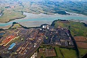
In 1966, the New Zealand Government announced plans for a steel mill near Waiuku. The Glenbrook Steel Mill started working in 1968. From 1969, it began collecting ironsand from land along the Waikato River.
Over time, Waiuku has become a service centre for the farms around it. Many people who work at the New Zealand Steel mill also live in Waiuku.
Waiuku's Population
Waiuku covers about 7.87 square kilometres. It has an estimated population of 10,700 people as of June 2024. This means there are about 1,360 people per square kilometre.
In 2018, Waiuku had a population of 9,168 people. This was an increase of 846 people since 2013. There were 3,261 homes. The population was almost half male (4,557) and half female (4,611). About 21.5% of people were under 15 years old.
Most people in Waiuku (83.0%) are of European descent. About 19.9% are Māori, 4.5% are Pacific peoples, and 6.4% are Asian. About 21.4% of people were born overseas.
When asked about religion, 56.2% said they had no religion. About 31.0% were Christian.
Marae in Waiuku
Waiuku has two marae (meeting grounds) that belong to the Waikato Tainui hapū (sub-tribes) of Te Ākitai, Ngāti Paretaua and Ngāti Te Ata. These are Reretēwhioi Marae, which has its Arohanui meeting house, and Tāhuna Marae, with its Teuwira meeting house.
Things to See and Do
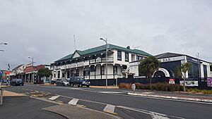
The local pub, called The Kentish Hotel, is New Zealand's oldest hotel that has continuously had a license. Edward Constable, an early European settler, built it as an inn in 1851. The hotel's name comes from his home county of Kent in England. The Kentish Hotel, with its fancy porches, is a historic landmark in the town. It's near the Tamakae Reserve.
At the entrance to the Reserve, there's a statue of Tamakae. It was carved from ancient swamp kauri logs. These logs were found during work at New Zealand Steel and given to the local iwi (tribe), Ngati Te Ata. The Reserve also has a small historic "village." It has several old buildings that have been fixed up. These include Hartmann House from 1886, which is now a craft studio. There's also Pollock Cottage (1890), Waiuku Jail (1865), and The Creamery (1890s).
The nearby Waiuku Museum shows local history. It has old items from the colonial era, Māori artifacts, old sailing boats, and historic photos. A heritage trail around town points out more historic places. This includes Wesley Methodist Church (1883), where you can get a great view of Waiuku and the waterfront. The Waiuku Museum opened in 1965.
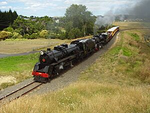
The Glenbrook Vintage Railway is a heritage railway that opened in 1977. It uses part of the old Waiuku branch line. This section was closed in 1967 but was saved.
The black sand beach, Karioitahi, is also nearby on the west coast.
Waiuku also has a pistol club with shooting ranges. It is home to one of New Zealand's largest airsoft clubs.
Schools in Waiuku
- Waiuku College is a high school for students in years 9 to 13.
- Waiuku Primary School, View Road School, and Sandspit Road School are primary schools for students in years 1 to 8.
All these schools teach both boys and girls.
Famous People from Waiuku
Some notable people who come from Waiuku include:
- David Aspin, an Olympic wrestler.
- Zinzan Brooke, a rugby player.
- Stephen Donald, a rugby player.
- Ross Ihaka, a statistics professor.
- Elsie Locke, a peace activist, historian, and writer. She spent much of her childhood in Waiuku. Her children's book The End of the Harbour: An Historical Novel for Children (1968) is set in Waiuku in the 1860s.
- George Makgill, a Scottish baronet and novelist. His father owned a farm in Waiuku in the 1870s.
- John Campbell Paterson, who was the Bishop of Auckland from 1994 to 2010.
- Kevin Skinner, a rugby player.
- Pat Walsh, a rugby player.
|
 | Toni Morrison |
 | Barack Obama |
 | Martin Luther King Jr. |
 | Ralph Bunche |


