Wallasea Wetlands facts for kids
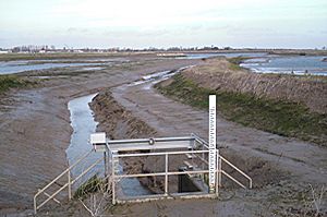
Wallasea Wetlands is a special area in Essex, England. It is a large wetland that was created by people. This project helped bring back important habitats for wild birds and other animals. It is now the biggest man-made wetland by the sea in the United Kingdom.
This wetland covers about 115 hectares (which is 1.15 square kilometers). It is located on Wallasea Island, between two rivers: the River Crouch and the River Roach. The wetlands offer a safe home for many animals. Wading birds come here in winter. It is also a place for fish like bass, mullet, flatfish, and herring to breed and grow. Even some types of dolphins visit this area.
The Wallasea Wetlands also help protect nearby homes from floods. They give floodwaters a place to go, which reduces the risk of flooding along the River Crouch.
How Wallasea Wetlands Was Made
The creation of Wallasea Wetlands involved a process called "managed re-alignment." This means that the old sea wall, which protected farmland, was moved. A new sea wall was built about three miles further inland. This allowed the sea to flow into the area where the new wetlands are now.
This new area became a perfect home for birds like oystercatchers, avocets, and little terns. The construction of the new sea wall was finished in 2006. By 2011, the land had changed into wetlands, mudflats, salty lagoons, and seven man-made islands. This created many new places for wildlife to live.
An even bigger part of the project was finished in July 2015. This involved using 2,400 boatloads of soil dug out from London's Crossrail tunnels. This soil helped create an extra area called Jubilee Marsh, which is about 160 hectares (400 acres). This new section was also opened to the tides. The entire Wallasea Wetlands project was completed by 2025.
A Look Back: Why Wallasea Wetlands Was Needed
Wetlands have been a part of Wallasea Island for a very long time. In the 15th century, Dutch settlers drained these lands to create farms. They built the first sea wall to do this. Over many years, more wetlands were drained for building new areas. This caused the number of wild animals and birds that relied on these wetlands to drop. Many became endangered.
In the late 1980s and early 1990s, two important wetland areas were lost. These were Lappel Bank in the Medway Estuary and Fagbury Flats in the Orwell Estuary. Both were drained to build new port developments. Because of this, a court ruled that these wetlands had to be replaced. This is why the Wallasea Wetlands project was started.
The Wallasea Wetlands project had several important goals:
- It needed to fit with existing plans for the coast and not harm other sensitive natural areas.
- It aimed to create a good, lasting home for birds that had lost their habitats over many years.
- It also had to provide extra protection against floods and storms for the area.
- Finally, it needed to create a nice environment for local people without negatively affecting businesses or fun activities.
The project to turn the island back into a salt marsh began in 2005. It cost £7.5 million. The first step was building the new sea defense wall. This wall marked the area where the tides would be allowed to flow. On July 4, 2006, 300 meters of the old sea wall were removed. This allowed the sea tides to flood the area at high tide, starting the new wetland.
 | May Edward Chinn |
 | Rebecca Cole |
 | Alexa Canady |
 | Dorothy Lavinia Brown |


