Walupt Lake facts for kids
Quick facts for kids Walupt Lake |
|
|---|---|

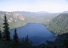
View of Walupt Lake from above on the southwest rim of the valley.
|
|
 |
|
| Location | Lewis County, Washington; Goat Rocks |
| Coordinates | 46°25′01″N 121°27′47″W / 46.41694°N 121.46306°W |
| Type | Tarn |
| Part of | Cispus River |
| Primary inflows | Walupt Creek |
| Primary outflows | Walupt Creek |
| Catchment area | 13.7 square miles (35 km2) |
| Managing agency | United States Forest Service |
| Designation | Partial wilderness area |
| Max. length | 6,475 feet (1,974 m) |
| Max. width | 4,140 feet (1,260 m) |
| Surface area | 350 acres (140 ha) |
| Average depth | 180 feet (55 m) |
| Max. depth | 300 feet (91 m) |
| Water volume | 62,000 acre-feet (76,000,000 m3) |
| Shore length1 | 3.4 miles (5.5 km) |
| Surface elevation | 3,927 feet (1,197 m) |
| 1 Shore length is not a well-defined measure. | |
Walupt Lake is a large freshwater lake found in the Gifford Pinchot National Forest. This forest is located within the Cascade Mountains of Washington. The lake is close to the town of Packwood. It is a popular spot for outdoor activities like camping, boating, and hiking. The eastern part of Walupt Lake is inside the Goat Rocks Wilderness, a special protected area. Walupt Lake is known for being the deepest and the second largest natural lake in Lewis County.
Contents
How Walupt Lake Was Formed
Walupt Lake is a type of lake called a ribbon lake. These lakes are long and narrow, often found in valleys carved by glaciers. Walupt Lake sits at the end of a long valley that was shaped by ancient glaciers.
Water Flow In and Out
The main water source for Walupt Lake is Walupt Creek. This creek flows all year round, fed by melting snow. It enters the lake at its eastern end. Other small streams also flow into the lake from the steep valley walls nearby. The area that collects water for the lake, called its watershed, covers about 13.7 square miles (35.5 square kilometers) in the southern Goat Rocks. This watershed includes the lake itself, forests, and other undeveloped land.
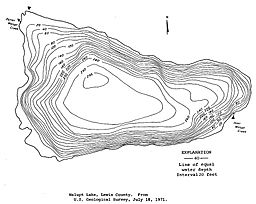
Walupt Creek also acts as the lake's outflow, meaning it's where water leaves the lake. The creek flows out from the lake's northwestern corner. The lake has a unique shape, a bit like a boot, with the "toe" pointing east up the valley.
Lake Size and Depth
The widest part of Walupt Lake is at its western end, measuring about 4,140 feet (1,260 meters) across. The longest part is along its southern side, stretching about 6,475 feet (1,974 meters). The lake covers an area of about 350 acres (140 hectares). Its average depth is around 180 feet (55 meters). Walupt Lake is the deepest lake in Lewis County. It is also one of the deepest lakes in Washington state, reaching a maximum depth of 300 feet (91 meters). The lake holds a large amount of water, about 62,000 acre-feet (76,000,000 cubic meters). This volume makes it one of the top 25 largest lakes by water volume in Washington.
How the Lake Was Created
Walupt Lake was formed a very long time ago by a natural event. A large landslide occurred when a ridge on the northwest side of the valley slid down. This created a natural dam, which then trapped water and formed the lake.
History of Walupt Lake's Name
The name Walupt was first given to the lake by a surveyor named Albert Hale Sylvester. He learned the name from Native Americans. Walupt is a word from the Yakama people, and it was their name for that entire region.
The Legend of the Deer
According to an old legend, a great Yakama hunter was chasing a powerful deer for many days. The deer eventually led him to this lake. The deer then jumped into the water, swam around for a while, and then disappeared. The legend says that ever since then, any hunter whose chase leads them to Walupt Lake might sometimes see the deer swimming in the water.
Fun Activities at Walupt Lake
The eastern part of Walupt Lake is located within the Goat Rocks Wilderness, which is part of the Gifford Pinchot National Forest. This area is protected and offers many opportunities for outdoor fun.
Camping and Boating
The Walupt Lake Campground is a popular place for camping and day trips. It is located on the west end of the lake. The campground has 42 basic campsites and a boat ramp, making it easy to get out on the water. It's also a great starting point for exploring the Goat Rocks Wilderness.
Hiking and Views
While you can't see much of the surrounding area from the lake itself, if you hike up to the ridges above, you'll get amazing views. From these higher spots, you can see the Goat Rocks all around you. You can also spot Mount Adams to the south and Mount Rainier to the northwest.
Two popular hiking trails start at the eastern end of the campground:
- The Nannie Ridge Trail #98
- The Walupt Lake Trail #101
Both of these trails offer different views of the wilderness and the surrounding area. They eventually connect with the famous Pacific Crest National Scenic Trail.
 | Roy Wilkins |
 | John Lewis |
 | Linda Carol Brown |


