
Wangen an der Aare facts for kids
Quick facts for kids
Wangen an der Aare
|
||
|---|---|---|
 |
||
|
||

Wangen an der Aare
Location in Switzerland

Wangen an der Aare
Location in Canton of Bern
|
||
| Country | Switzerland | |
| Canton | Bern | |
| District | Oberaargau | |
| Area | ||
| • Total | 5.22 km2 (2.02 sq mi) | |
| Elevation | 423 m (1,388 ft) | |
| Population
(Dec 2020 )
|
||
| • Total | 2,377 | |
| • Density | 455.4/km2 (1,179.4/sq mi) | |
| Postal code |
3380
|
|
| Surrounded by | Attiswil, Deitingen (SO), Flumenthal (SO), Walliswil bei Wangen, Wangenried, Wiedlisbach | |

Wangen an der Aare is a town in Switzerland. It is a municipality located in the Oberaargau administrative district. This area is part of the canton of Bern.
On January 1, 2024, the nearby town of Wangenried joined with Wangen an der Aare. This made Wangen an der Aare a larger municipality.
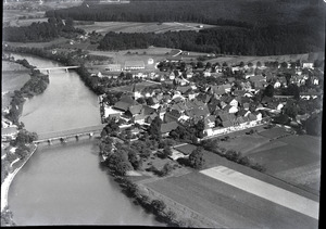
This small town sits between the cities of Olten and Solothurn. It is in a rural area along the Aare river. The Aare is a major river in the central lowlands of Switzerland, called the Mittelland. An old wooden covered bridge crosses the Aare river right here. Wangen an der Aare used to be the main town for its old district.

Contents
Getting Around Wangen
Wangen is easy to reach. It is located on the Biel/Bienne - Olten railway line. This means you can get there by train. It is also close to the A1 motorway, which is a major highway.
Wangen's History
The name "Wang(en)" means an area at the bottom of a hill. In this case, it likely refers to the nearby Jura mountain range.
Town Symbols
Wangen's coat of arms shows two crossed keys in blue on a white background. This symbol was used by the local rulers, called Vögte. It came from the Abbey of Saint Peter in the Black Forest, which owned land in the Upper Aargau region. The oldest document with this crossed-keys symbol is from the year 1380.
The Castle and River Trade
A castle was built in 1407 by the Kyburger family. This castle became the main office for the Bernese regional government. Even today, some government offices are still in the building.
The town was in a very important spot. It guarded where people crossed the river. It also served as a place to collect taxes and stop for boats traveling on the Aare river. When river trade ended, the town faced tough economic times. The old salt house from 1775 still stands today. It reminds us of this past trade.
Wangen's Geography
Wangen covers an area of about 6.8 square kilometers (2.6 square miles). A large part of this land, about 42.8%, is used for farming. Forests cover about 28.8% of the area. About 20.3% of the land has buildings or roads. The rest, about 8.1%, is made up of rivers or other natural areas.
People of Wangen
Wangen has a population of 2,377 people. Many different people live here. Most people (91.0%) speak German. Albanian is the second most common language (3.0%), followed by Serbo-Croatian (2.4%).
In Wangen, about 24% of the people are children and teenagers (0–19 years old). Adults (20–64 years old) make up 59.6% of the population. Seniors (over 64 years old) make up 16.4%. About 75.3% of adults (aged 25-64) have finished high school or gone on to higher education.
Wangen has a low unemployment rate of 1.76%. This means most people who want to work have jobs.
Famous People from Wangen
- Arnold Rikli (1823–1906) was born in Wangen an der Aare. He was a natural healer from Switzerland. He believed that exposing the body to sun and air, like sun tanning, was good for health.
Army Base in Wangen
Wangen has a modern Swiss Army base. This shows the town's long history as a military center. The base started around the riverside warehouses. During World War I, howitzer units (a type of artillery) were stationed there.
Today, Wangen an der Aare is the main center for the Transport Corps. It is also a training place for disaster relief and rescue teams. The Pontoniers, who are bridge-builders in the Corps of Engineers, also train here.
Wangen's Economy
The company Roviva Roth & Cie. AG makes bedding products. It started as a horsehair spinning-mill in 1748. This shows the town's long history of industry.
See also
 In Spanish: Wangen an der Aare para niños
