
Attiswil facts for kids
Quick facts for kids
Attiswil
|
||
|---|---|---|

Municipal administration building in Attiswil village
|
||
|
||

Attiswil
Location in Switzerland

Attiswil
Location in Canton of Bern
|
||
| Country | Switzerland | |
| Canton | Bern | |
| District | Oberaargau | |
| Area | ||
| • Total | 7.65 km2 (2.95 sq mi) | |
| Elevation | 464 m (1,522 ft) | |
| Population
(Dec 2020 )
|
||
| • Total | 1,532 | |
| • Density | 200.26/km2 (518.7/sq mi) | |
| Postal code |
4536
|
|
| Surrounded by | Farnern, Flumenthal (SO), Günsberg (SO), Hubersdorf (SO), Kammersrohr (SO), Rumisberg, Wangen an der Aare, Wiedlisbach | |

Attiswil is a small town, also called a municipality, in the Oberaargau area of the canton of Bern in Switzerland.
Contents
History of Attiswil

Attiswil was first written about in the year 1364. Its name back then was Attenswile.
Early Settlements and Roman Times
People have lived in the area around the Aare river for a very long time, even as far back as the Mesolithic period (Middle Stone Age). Scientists have found signs of settlements from the Stone Age, Bronze Age, and La Tène times in Attiswil. During the Roman era, there were many farms and villages here. There was even a large standing stone, called a menhir, which might be even older than the Roman times.
Medieval Period and Changes in Control
In the Middle Ages, Attiswil was part of a territory called the Herrschaft of Bipp. In 1413, the cities of Solothurn and Bern bought this whole area and ruled it together. Later, in 1463, Bern took full control. Attiswil then became part of the Wiedlisbach court in the Bipp District.
Religious Changes
Originally, Attiswil was part of the Flumenthal parish, which was Catholic. But in 1528, Bern decided to follow the new Protestant Reformation faith and made everyone in its canton convert. Solothurn stayed Catholic. In 1533, Bern made Attiswil leave the Catholic Flumenthal parish and join the new Protestant Oberbipp parish. A new church was built in Attiswil in 1948. After the French invasion in 1798, Attiswil became part of the Helvetic Republic district of Wangen.
First School in Attiswil
The first mention of a school in Attiswil was in 1633. A school building was built in 1707. Today, this old school building is used as the main office for the town's government.
Geography of Attiswil
_097.JPG)
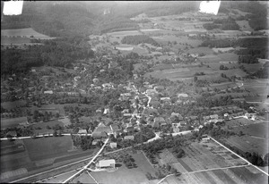
Attiswil covers an area of about 7.7 square kilometers (about 3 square miles).
Land Use
Most of Attiswil's land is used for farming, about 53.1%. Forests cover a large part too, about 35.2%. The rest of the land, about 11%, has buildings or roads. A very small part is rivers or lakes, and some land is not used for anything.
Location and Landscape
The town is located near the Aare river. However, since 1881, the town's border does not directly touch the river. Attiswil's area includes flat lands near the Aare river and also a mountain called Bettlerküche, which is part of the Jura Mountains. This mountain is about 1,074 meters (3,524 feet) high.
Administrative Changes
On January 1, 2010, Attiswil became part of the new Verwaltungskreis Oberaargau administrative district.
Attiswil's Coat of Arms
The blazon (description) of Attiswil's coat of arms is: a red shield with a gold cross. Above the cross are two gold stars, and below it are two green clover-like shapes growing from a green hill.
Population and People


Attiswil has a population of about 1,324 people (as of December 2012). About 7.8% of the people living here are from other countries.
Languages Spoken
Most people in Attiswil speak German as their main language, about 94.6%. Other languages spoken include Serbo-Croatian and Italian.
Age Groups
In Attiswil, about 18.1% of the population are children and teenagers (0–19 years old). Adults (20–64 years old) make up about 58.5%, and seniors (over 64 years old) are about 23.5% of the population.
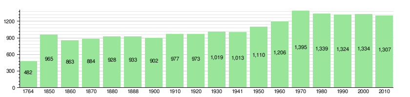
Population Over Time
The number of people living in Attiswil has changed over the years, as shown in this chart:
Economy and Jobs


In 2011, Attiswil had a low unemployment rate of 2.27%. Many people work in the town itself, and many others travel to nearby cities for their jobs.
Types of Jobs
Attiswil has jobs in three main areas:
- Primary sector: This includes jobs like farming and forestry. About 75 people work in this area.
- Secondary sector: This includes jobs in manufacturing and construction. About 90 people work in this area.
- Tertiary sector: This includes jobs in services, like sales, transportation, hotels, and education. About 194 people work in this area.
Many residents of Attiswil travel to other towns for work. About 11.6% of working people use public transportation, and 59.6% use a private car to get to work.
Attiswil's Heritage Site
The entire village of Attiswil is recognized as part of the Inventory of Swiss Heritage Sites. This means it's a special place with important historical and cultural value.
Religion in Attiswil

According to a 2000 survey, most people in Attiswil, about 71.4%, belong to the Swiss Reformed Church (a Protestant church). About 17.2% are Roman Catholic. A smaller number of people belong to other Christian churches, or are Muslim or Hindu. About 6.15% of the population do not belong to any church.
Education in Attiswil

In Attiswil, about 62.7% of the adults have finished high school, and 14.7% have gone on to higher education, like a university.
School System
The school system in the Canton of Bern works like this:
- One year of optional Kindergarten.
- Six years of Primary school.
- Three years of required lower Secondary school, where students are grouped by their abilities.
After lower Secondary school, students can choose to continue their education or start an apprenticeship (learning a trade on the job).
Student Numbers
During the 2012-2013 school year, 97 students attended schools in Attiswil.
- There were 23 students in kindergarten classes.
- There were 74 students in primary school classes.
Most students who live in Attiswil also go to school there.
See also
 In Spanish: Attiswil para niños
