Wapanucka, Oklahoma facts for kids
Quick facts for kids
Wapanucka, Oklahoma
|
|
|---|---|

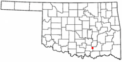
Location of Wapanucka, Oklahoma
|
|
| Country | United States |
| State | Oklahoma |
| County | Johnston |
| Area | |
| • Total | 0.66 sq mi (1.70 km2) |
| • Land | 0.65 sq mi (1.68 km2) |
| • Water | 0.01 sq mi (0.02 km2) |
| Elevation | 633 ft (193 m) |
| Population
(2020)
|
|
| • Total | 386 |
| • Density | 593.85/sq mi (229.25/km2) |
| Time zone | UTC-6 (Central (CST)) |
| • Summer (DST) | UTC-5 (CDT) |
| ZIP code |
73461
|
| Area code(s) | 580 |
| FIPS code | 40-78300 |
| GNIS feature ID | 2413448 |
Wapanucka (pronounced Wop´-uh-nuck´-uh) is a small town in northeastern Johnston County, Oklahoma, United States. In 2020, about 386 people lived there. The town's name comes from the Delaware Nation and means "Eastern Land People." It is located about 20 miles (32 km) northeast of Tishomingo.
Contents
History of Wapanucka
The story of Wapanucka includes an important school. In 1851, the Board of Foreign Missions of the Presbyterian Church built the Wapanucka Female Manual Labour School. It opened in 1852 and was named after a nearby creek.
The School's Names
Local people often called the school Allen's Academy. This was because James S. Allen was in charge of it. Later, many people called it Rock Academy. This was because of its impressive stone building.
School Closure and Reopening
The school closed in 1860 when the Presbyterian Board stopped providing money. During the American Civil War, Confederate soldiers used the building as a hospital and a prison. After the war, the academy reopened. It taught both boys and girls. In 1890, it became a school just for boys. The school closed for good in 1911, and the land was sold.
Historic Site Recognition
In 1972, the Wapanucka Academy site was added to the National Register of Historic Places. This means it is an important historical location.
Geography of Wapanucka
Wapanucka is located about 20 miles (32 km) northeast of Tishomingo. Tishomingo is the main town, or county seat, of Johnston County.
Land and Water Area
According to the United States Census Bureau, the town covers a total area of about 0.7 square miles (1.8 km2). Most of this area, about 0.7 square miles (1.8 km2), is land. A very small part, about 1.49%, is water.
Population and People
| Historical population | |||
|---|---|---|---|
| Census | Pop. | %± | |
| 1910 | 948 | — | |
| 1920 | 1,038 | 9.5% | |
| 1930 | 553 | −46.7% | |
| 1940 | 730 | 32.0% | |
| 1950 | 592 | −18.9% | |
| 1960 | 459 | −22.5% | |
| 1970 | 425 | −7.4% | |
| 1980 | 472 | 11.1% | |
| 1990 | 402 | −14.8% | |
| 2000 | 445 | 10.7% | |
| 2010 | 438 | −1.6% | |
| 2020 | 386 | −11.9% | |
| U.S. Decennial Census | |||
In 2000, there were 445 people living in Wapanucka. These people lived in 174 households, and 117 of these were families.
Population Details
About 32.2% of the households had children under 18 years old. About 52.9% of households were married couples living together. The average household had about 2.56 people. The average family had about 3.12 people.
Age Groups
The population was spread out by age:
- About 27.9% were under 18 years old.
- About 10.3% were between 18 and 24 years old.
- About 25.8% were between 25 and 44 years old.
- About 18.4% were between 45 and 64 years old.
- About 17.5% were 65 years old or older.
The average age in the town was 33 years.
Notable People from Wapanucka
Some important people have come from Wapanucka:
- Jack P. Juhan was a Marine Corps officer during World War II. He reached the high rank of major general.
- Harriet Wright O'Leary (1916-1999) was a teacher and politician. She was the first woman to serve on the tribal council of the Choctaw Nation of Oklahoma. A tribal council is a group of leaders who help govern a Native American tribe.
- Richard Lowell Weathers served as the Mayor of Mustang, Oklahoma, from 1981 to 1985.
See also
 In Spanish: Wapanucka (Oklahoma) para niños
 | Bessie Coleman |
 | Spann Watson |
 | Jill E. Brown |
 | Sherman W. White |

