Waroona, Western Australia facts for kids
Quick facts for kids WaroonaWestern Australia |
|||||||||||||||
|---|---|---|---|---|---|---|---|---|---|---|---|---|---|---|---|

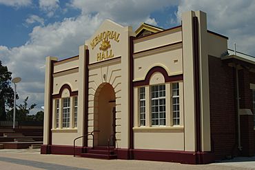
Waroona Memorial Hall
|
|||||||||||||||
| Established | 1895 | ||||||||||||||
| Postcode(s) | 6215 | ||||||||||||||
| Area | [convert: needs a number] | ||||||||||||||
| Location | |||||||||||||||
| LGA(s) | Shire of Waroona | ||||||||||||||
| State electorate(s) | Murray-Wellington | ||||||||||||||
| Federal Division(s) | Canning | ||||||||||||||
|
|||||||||||||||
Waroona is a town in the Peel region of Western Australia. It sits along the South Western Highway, between the towns of Pinjarra and Harvey. Waroona is the main town for the Shire of Waroona area. In 2016, about 2,934 people lived in Waroona.
Contents
The Story of Waroona: From Drakesbrook to Today
Early Days and First Settlers
The area where Waroona is now was first called Drakesbrook. John Fouracre was the first person to settle here in 1891. A railway station named "Drake's Brook" opened in September 1893. It was named after William Henry Drake, an early landholder. The town was officially planned and named Drakesbrook in March 1895. The name was changed from "Drake's Brook" to "Drakesbrook" because it sounded better. A post office opened in 1896.
How Waroona Got Its Name
In 1895, Joseph McDowell built a timber mill in the northern part of Drakesbrook. A railway siding was opened near this mill. Because the first town layout was not popular, new land lots were planned near the mill. This new area became known as Waroona. The name "Waroona" likely came from "Werroona" in Victoria, which was McDowell's hometown. The original word "Werroona" means "resting place" in the Djadjawurrung language.
Growth and Development
The railway helped the town grow a lot. Local timber was cut into sleepers for the railway tracks. The town provided services for the mill workers. These included a post office, a general store, a school, and places to stay. Farms in the area supplied food like butter, fruit, and vegetables. They also provided feed for the horses that pulled the logs. In March 1899, McDowell's Siding became Waroona Station. From 1904 to 1947, Waroona Station earned the most money from outgoing rail traffic on the South Western Railway.
For many years, people used both "Drakesbrook" and "Waroona" to talk about the area. At first, they were two separate settlements about 2 kilometres apart. Waroona was where most of the new buildings and businesses were. Over time, the two settlements joined together into one town. This town became known as Waroona. The name was officially changed in 1946.
Dams and Water for the Town
The first Waroona Dam, now called Drakesbrook Dam, was built between 1931 and 1932. People who were out of work during the Great Depression helped build it. This dam, along with new drainage and irrigation systems, helped Waroona develop a lot. The current Waroona Dam, which is further up in the hills, opened in 1966.
Historic Railway Cottages
Railway cottages were built in 1896 for railway workers. These cottages are still standing today and are protected as historic buildings. They are the only surviving timber and iron cottages for railway track workers in Western Australia from the 1800s.
Farming and Industry
Waroona once had a local Nestlé milk factory. It made milk products until the mid-1900s. Now, that building is used for heavy machinery.
2016 Bushfire Disaster
How the Fire Started and Spread
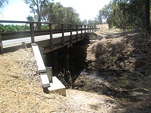
In January 2016, a large bushfire started near Nanga Brook. It was caused by a lightning strike. The fire caused a lot of damage to the bushland, homes, and other buildings. The Samson Brook bridge on the South Western Highway was also destroyed.
Impact on Nearby Towns
The fire started on January 6, 2016, and burned out of control for a long time. Over 21,000 hectares of land were burned. People living in the area had to leave their homes and go to safe places in Pinjarra or Australind. The towns of Yarloop and Harvey were also in danger. Most of Yarloop was destroyed by the fire. The town of Preston Beach became cut off, and some residents had to go to the beach or leave by boat.
Waroona Today: Life and Activities
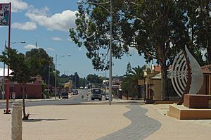
Waroona is located on the South Western Highway, about 113 kilometres south of Perth. It is at the foot of the Darling Range. About 1,800 people live there today.
Economy and Local Events
Farming, especially dairy farming, and tourism are the main ways people make a living in Waroona. An irrigation system from the Drakesbrook Weir provides water for the town and nearby farms. Every October, Waroona hosts the Waroona Agricultural Show, which is a big event for the community.
Sports and Recreation
The town has a recreation centre and two public sports ovals. There used to be a meat processing plant in Waroona, but now one in nearby Harvey does this work. Some Waroona residents work there. You can find everything you need for shopping at local businesses and supermarkets.
Popular Tourist Spots
Waroona Dam and Drakesbrook Weir are popular places for tourists and picnics. You can go camping there and enjoy activities like canoeing and water-skiing. Waroona also has several heritage trails and shops selling art and crafts. The current leader of the local council is Mike Walmsley.
Schools and Learning
There are two schools in Waroona:
- St Joseph's Primary School (a Catholic school)
- Waroona District High School, which teaches students from kindergarten up to junior high school.
Most students go to senior high school in nearby towns like Pinjarra, Harvey, and Mandurah.
The Old Drakesbrook School House
On July 26, 2005, the Drakesbrook School House burned down. It first opened in 1898 as a one-room school. It had been closed since the 1980s but was kept as a historic site. After the fire, the remaining parts of the building were removed. A year later, the local council decided to build a memorial to the school on the site.
Art and Culture in Waroona
The Waroona Visitor Centre has a gallery that shows local art and crafts. Since 1998, public artworks have been placed around the town. This was part of a project by Alcoa and the Fremantle Arts Centre. These artworks include:
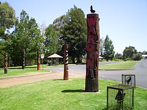
- A "forest" of heritage bush poles near the northern tourist information area. These are jarrah poles that have been carved and painted.
- A large concrete sofa that weighs 24 tonnes. It has a patchwork quilt knitted by over 60 local women. The quilt pieces show different parts of life in Waroona.
The Waroona Heritage Trail lets you walk or drive past historic buildings and sites. Artistic posts mark the trail. The guide book for the trail has sketches of the sites drawn by local artists.
Getting Around Waroona
Road Travel
The main road that goes through Waroona is the South Western Highway (Route 20). This highway connects Perth to Bunbury, passing through Pinjarra and Harvey.
Train Travel
Waroona is on the South Western Railway line. The Australind passenger train stops here. This train travels between Perth and Bunbury.
| Preceding station | Following station | |||
|---|---|---|---|---|
| Pinjarra
towards Perth
|
Australind | Yarloop
towards Bunbury
|
||
 | Mary Eliza Mahoney |
 | Susie King Taylor |
 | Ida Gray |
 | Eliza Ann Grier |


