
Water of Leith (New Zealand) facts for kids
Quick facts for kids Water of Leith |
|
|---|---|

Upper reaches of the Water of Leith, Woodhaugh, Dunedin
|
|


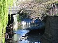
Mouth of the Water of Leith
|
|
| Country | New Zealand |
| Physical characteristics | |
| Main source | Leith Saddle Sullivans Dam 380 m (1,250 ft) 45°48′31″S 170°31′20″E / 45.80868°S 170.5221°E |
| River mouth | Otago Harbour 0 m (0 ft) 45°52′19″S 170°31′33″E / 45.87183°S 170.52581°E |
| Length | 14 km (8.7 mi) |
| Basin features | |
| Progression | Water of Leith → Otago Harbour → Pacific Ocean |
| Tributaries |
|
| Bridges | George Street Bridge, St David Street Footbridge, University of Otago Stone Bridge, Leith Walk Bridge, Water of Leith Footbridge |
The Water of Leith is a small river in the South Island of New Zealand. It is also known by other names like Ōwheo or the River Leith.
This river starts north of the city of Dunedin. It flows for about 14 kilometers (9 miles) through the northern part of the city. It also passes through the campus of the University of Otago. Finally, it reaches the Otago Harbour. Dunedin's name comes from the Scottish city of Edinburgh. So, the river is named after the Water of Leith in Scotland too. The original Māori name for the river was Ōwheo. This means "The place of Wheo," named after a local chief.
Contents
Where the Water of Leith Flows
The Leith river starts near the Dunedin Northern Motorway. This is part of State Highway 1. Its source is about 380 meters (1,247 feet) above sea level. This spot is close to Leith Saddle.
Water Supply for Dunedin
From its source, the Leith flows south. It goes around a water supply reservoir called Sullivan's Dam. This dam was built in 1916. This reservoir helps provide drinking water for Dunedin. Another important water source is the Ross Creek Reservoir. It is on Ross Creek, which flows into the Leith.
The Leith then flows southwest through the wooded Leith Valley. A gravel road follows the river here. It becomes a paved road as the river reaches the city at Glenleith. Several smaller streams join the Leith along this path. One of these is Morrison's Burn.
The River in Urban Dunedin
As the river enters Dunedin, it can be quite small. This is because a lot of its water is taken for drinking upstream. Much of northern Dunedin is built on the river's flat area, called a floodplain.
The Ross Creek joins the Leith between Glenleith and Woodhaugh. The Ross Creek Reservoir is a historic project. It has many popular walking tracks around it. The upper Leith Valley also has walking paths. However, some parts are closed to protect the water supply. Near this meeting point, you can see old watermills. Woodhaugh was once an industrial area. From here, the Leith turns southeast. It flows through Woodhaugh Gardens, a public park.
Preventing Floods in Dunedin
The lower parts of the Leith are now in concrete channels. These channels and small dams were built to stop floods. A big flood in March 1929 caused serious damage to Dunedin North. Another bad flood happened in 1868. The Leith used to wind through what is now the city center. It flowed into the harbor where Cumberland and Stuart Streets are today.
The Leith enters a wider flat area at the end of Woodhaugh Gardens. This is where most of Dunedin's city area is. It flows around the northern edge of the floodplain. It passes the Dunedin Botanic Gardens. Here, another main stream, Lindsay Creek, joins it. Lindsay Creek flows from Mount Cargill and through North East Valley. In the Botanic Gardens, there is a statue of a trout. It marks where the first brown trout were released into a New Zealand river in 1869. They came from Tasmania.
The River and the University
The Leith then turns south. It flows through the middle of the University of Otago campus. Then it turns east. It passes the Otago Polytechnic and the Dunedin College of Education. It also goes by Forsyth Barr Stadium. Finally, it reaches the Otago Harbour near Logan Park.
In 2018, a new cable-stay footbridge was built over the mouth of the Water of Leith. This bridge is called the Water of Leith Footbridge. It cost about NZ$1.4 million to build. The bridge is 45 meters (148 feet) long. It was finished in December 2018.
In the early 1900s, people sometimes called the river the "Leith Canal." This name is not used much anymore.
Images for kids
-
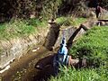
The headwaters of the Water of Leith are diverted around Sullivan's Dam in concrete channels.
-
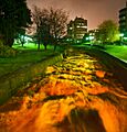
The Water of Leith by the University of Otago after a lot of rain.
-
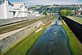
Water of Leith close to its mouth in Dunedin.
-
St David Street Footbridge at the University of Otago.
-
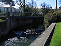
The University of Otago Stone Bridge, also known as the Union Street Bridge.


