
Waverley, Queensland facts for kids
Quick facts for kids WaverleyQueensland |
|||||||||||||||
|---|---|---|---|---|---|---|---|---|---|---|---|---|---|---|---|

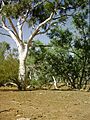
Landscape beside the Boulia Mount Isa Highway, 2019
|
|||||||||||||||

Waverley
Location in Queensland
|
|||||||||||||||
| Population | 6 (2021 census) | ||||||||||||||
| • Density | 0.00065/km2 (0.0017/sq mi) | ||||||||||||||
| Postcode(s) | 4825 | ||||||||||||||
| Area | 9,244.8 km2 (3,569.4 sq mi) | ||||||||||||||
| Time zone | AEST (UTC+10:00) | ||||||||||||||
| Location |
|
||||||||||||||
| LGA(s) | Shire of Boulia | ||||||||||||||
| State electorate(s) | Gregory | ||||||||||||||
| Federal Division(s) | Kennedy | ||||||||||||||
|
|||||||||||||||
Waverley is a very small, remote place in the Shire of Boulia, Queensland, Australia. It's known as a "locality," which is like a small district or area. In 2021, only 6 people lived in Waverley.
Contents
Exploring Waverley's Geography
Waverley is located in a special area called the Channel Country. This region has many rivers and streams that usually dry up before their water reaches a large lake called Lake Eyre. This means the water doesn't always flow all the way to the lake.
Most of the land in Waverley is used for grazing. This means farmers raise animals like cattle or sheep on the natural plants that grow there.
Roads and Travel in Waverley
The main road in Waverley is the Boulia Mount Isa Highway. This highway enters Waverley from the north-east, coming from Mount Isa. It then leaves the area towards the east, heading to Dajarra.
Mountains and Hills in Waverley
Waverley is home to several mountains and hills. Here are some of them, listed from north to south:
- Rifle Creek Hill, which is about 542 meters (1,778 feet) tall.
- Mount Guide.
- Mount Woodhouse.
- Pinnacle Knob, standing at about 276 meters (906 feet).
- Steamboat Hill, which is around 301 meters (988 feet) high.
- McCabe Knob.
Who Lives in Waverley?
The number of people living in Waverley is very small.
- In 2016, there were 20 people living in Waverley.
- By 2021, the population had decreased to just 6 people.
Waverley's Special Places
Waverley has one important historical site that is protected because of its heritage. This site is:
- The Moonah Creek Hanging Tree at Ardmore Station. It's a significant part of the area's history.
Learning and Education in Waverley
There are no schools directly in Waverley. For primary school, children would likely need to travel to Mount Isa or Dajarra. However, traveling there every day might be difficult because of the distance.
For high school, the closest option is in Mount Isa. The Spinifex State College in Mount Isa offers places for students to live at the school (called boarding facilities). Another choice for students in Waverley would be to attend other boarding schools or learn from home through distance education.
How Waverley Makes a Living
The main way people live and work in Waverley is through farming and raising animals. There are several large farms, called homesteads, located throughout the area. These include:
- Mount Guide Homestead
- Sheila Outstation
- Oban Homestead
- Suva Downs Outstation
- Ardmore Homestead
- Douglas Downs Outstation
- Kallala Homestead
- Quewar Outstation
Images for kids
-
Moonah Creek Hanging Tree, 1964
.jpg)
