Waverly, Tennessee facts for kids
Quick facts for kids
Waverly, Tennessee
|
|
|---|---|
|
City
|
|

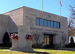
Humphreys County Courthouse in Waverly
|
|

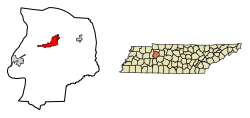
Location of Waverly in Humphreys County, Tennessee.
|
|
| Country | United States |
| State | Tennessee |
| County | Humphreys |
| Incorporated | 1838 |
| Named for | Waverley Novels of Sir Walter Scott |
| Area | |
| • Total | 8.71 sq mi (22.57 km2) |
| • Land | 8.71 sq mi (22.57 km2) |
| • Water | 0.00 sq mi (0.00 km2) |
| Elevation | 535 ft (163 m) |
| Population
(2020)
|
|
| • Total | 4,297 |
| • Density | 493.11/sq mi (190.40/km2) |
| Time zone | UTC-6 (Central (CST)) |
| • Summer (DST) | UTC-5 (CDT) |
| ZIP code |
37185
|
| Area code(s) | 931 |
| FIPS code | 47-78560 |
| GNIS feature ID | 1273950 |
Waverly is a city in Tennessee, United States. It is the main town, also known as the county seat, of Humphreys County. In 2020, about 4,297 people lived there.
Contents
History of Waverly
Early Beginnings and Naming
Waverly started as a stop for stagecoaches in the early 1800s. It was on the road between Nashville and Memphis. A man named Steven Pavatt founded the stop. He really liked the books of Sir Walter Scott. So, he named the community after Scott's famous Waverley Novels.
Becoming the County Seat
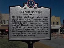
When Humphreys County was first created in 1803, the main town was Reynoldsburg. This town was located northwest of Waverly, along the Tennessee River. However, in 1835, some county lands became part of a new county called Benton County. This made Waverly a more central spot in Humphreys County. Because of this, Waverly became the new county seat. A courthouse was built in 1836, and Waverly officially became a town in 1838.
Waverly During the Civil War
During the American Civil War, Waverly and most of Middle and West Tennessee supported the Confederacy. In 1861, everyone in Humphreys County voted to leave the United States. In 1863, soldiers from the Union army came to Waverly. They were there to protect the railroad that went to Johnsonville. Johnsonville was a major supply center for the Union.
The Union soldiers built a fort near the courthouse. But Confederate fighters, called guerillas, often bothered them. On November 4, 1864, Confederate troops led by Nathan Bedford Forrest attacked Johnsonville. They destroyed the Union supply center. This event is known as the Battle of Johnsonville. It happened about 10 miles (16 km) west of Waverly.
Nearby Historical Sites
A few miles south of Waverly is Hurricane Mills. In the late 1800s and early 1900s, it had a large mill and a factory for processing wool. Near Hurricane Mills, there was also an ancient village from the Mississippian culture period. This site is known as the Duck River Temple Mounds. A farm once owned by the famous outlaw Jesse James was also in this area.
Important Events in Recent History
On February 24, 1978, a train carrying propane crashed in downtown Waverly. A propane tank car then exploded. This sad event caused 16 people to lose their lives. After this, the Tennessee Emergency Management Agency changed how it handles dangerous material spills. New safety rules were also made for things like train car design. These changes were put in place by the National Transportation Safety Board.
On August 21, 2021, Waverly experienced very heavy rainfall. Over 17 inches (43 cm) of rain fell, causing Trace Creek to flood the town. This led to major flooding in Waverly. Many homes and businesses were damaged or washed away. Services like electricity, phone, and water were also affected. The flood also impacted churches and Waverly Elementary School. All roads into and out of town became blocked. Sadly, 20 people in Humphreys County died because of the flood.
Geography of Waverly
Waverly is located at 36°5′9″N 87°47′13″W. The city sits in the Trace Creek Valley. This valley is just over 10 miles (16 km) east of where Trace Creek flows into Kentucky Lake. Kentucky Lake is part of the Tennessee River. The low hills around Waverly are part of the western edge of the Highland Rim region.
Waverly is at a key intersection of two major roads. U.S. Route 70 connects Waverly to Nashville in the east and Memphis in the west. State Route 13 connects the city to Hurricane Mills and Interstate 40 to the south. It also goes north towards rural areas near Erin.
The United States Census Bureau says that Waverly covers about 8.1 square miles (21 km2) of land. There is no water area within the city limits.
Population Information
| Historical population | |||
|---|---|---|---|
| Census | Pop. | %± | |
| 1850 | 174 | — | |
| 1860 | 288 | 65.5% | |
| 1870 | 207 | −28.1% | |
| 1880 | 510 | 146.4% | |
| 1900 | 786 | — | |
| 1910 | 947 | 20.5% | |
| 1920 | 1,054 | 11.3% | |
| 1930 | 1,152 | 9.3% | |
| 1940 | 1,318 | 14.4% | |
| 1950 | 1,892 | 43.6% | |
| 1960 | 2,891 | 52.8% | |
| 1970 | 3,794 | 31.2% | |
| 1980 | 4,405 | 16.1% | |
| 1990 | 3,925 | −10.9% | |
| 2000 | 4,028 | 2.6% | |
| 2010 | 4,105 | 1.9% | |
| 2020 | 4,297 | 4.7% | |
| Sources: | |||
2020 Census Details
| Race | Number | Percentage |
|---|---|---|
| White (non-Hispanic) | 3,657 | 85.11% |
| Black or African American (non-Hispanic) | 282 | 6.56% |
| Native American | 12 | 0.28% |
| Asian | 18 | 0.42% |
| Other/Mixed | 184 | 4.28% |
| Hispanic or Latino | 144 | 3.35% |
According to the 2020 United States census, Waverly had 4,297 people. There were 1,730 households and 939 families living in the city.
2010 Census Details
In 2010, the city had 4,105 people. This meant there were about 468 people per square mile (181 per km2). There were also 1,877 homes, with about 214 homes per square mile (83 per km2).
Famous People From Waverly
- Deborah Adams, an author
- Murray Bowen, a psychiatrist and professor
- Susan Goodman, who was named Mrs. America in 1983
- George Morgan, a country music singer
- Daryl Mosley, a singer, musician, and songwriter
See also
 In Spanish: Waverly (Tennessee) para niños
 | Kyle Baker |
 | Joseph Yoakum |
 | Laura Wheeler Waring |
 | Henry Ossawa Tanner |


