
Weengallon facts for kids
Quick facts for kids WeengallonQueensland |
|||||||||||||||
|---|---|---|---|---|---|---|---|---|---|---|---|---|---|---|---|

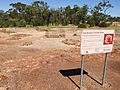
Weengallon locality sign, eastern approach (2021)
|
|||||||||||||||

Weengallon
Location in Queensland
|
|||||||||||||||
| Population | 46 (2021 census) | ||||||||||||||
| • Density | 0.0538/km2 (0.139/sq mi) | ||||||||||||||
| Postcode(s) | 4497 | ||||||||||||||
| Area | 855.5 km2 (330.3 sq mi) | ||||||||||||||
| Time zone | AEST (UTC+10:00) | ||||||||||||||
| Location |
|
||||||||||||||
| LGA(s) | Goondiwindi Region | ||||||||||||||
| State electorate(s) | Southern Downs | ||||||||||||||
| Federal Division(s) | Maranoa | ||||||||||||||
|
|||||||||||||||
Weengallon is a small rural area in Queensland, Australia. It is part of the Goondiwindi Region. In 2021, 46 people lived in Weengallon. This quiet locality has a rich history, especially with its ancient Indigenous rock wells.
Contents
Discovering Weengallon: A Small Australian Locality
Where is Weengallon? Understanding its Geography

The Barwon Highway runs through Weengallon. It connects the area to nearby towns like Talwood and Thallon. A railway line also passes through the southern part of the locality. These routes help people and goods travel in and out of Weengallon.
A Journey Through Time: Weengallon's History
Ancient Water Sources: The Ngaru-gi Gali Rock Wells
The Ngaru-gi Gali rock wells are very important. These are four large water holes, some about twelve meters deep. There are also several smaller ones. Indigenous Australians, including the Kalkadoon people, used these wells for thousands of years. They were vital stops on long journeys for ceremonies and trade. These routes connected places like Mount Isa to Goondiwindi and even the Bunya Mountains. Another similar rock well exists near Saint George.
-
Weengallon Aboriginal rock wells (2021).
-
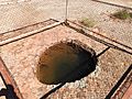
A large rock well (2021).


Early European Settlement and Community Life
A large farm, also called Weengallon, was established by 1867. At first, it was used for cattle. Water was sometimes scarce, and the farm was far from a railway. To solve this, a deep water well was dug in 1911. This well reached down about 3000 feet (914 meters). By 1913, the Weengallon Progress Association was formed. This was a group of local people working to improve their community.
Schools and Churches: Building a Community
Weengallon State School first opened its doors on April 13, 1916. However, it closed in 1922 because not enough students attended. The school reopened on January 30, 1962. It closed permanently in 1986. By the 1930s, the area had a public hall. This hall hosted many community events, like dances and cricket games. The Catholic Church of Our Lady Queen of Fatima was opened on March 6, 1955. A special 70-year celebration was held at the church on March 2, 2025. Weengallon was officially named and its boundaries set on November 26, 1999.
Who Lives in Weengallon? Population Facts
The number of people living in Weengallon has changed over time. In 2016, there were 30 residents. By 2021, the population had grown to 46 people.
Community Hubs: Weengallon's Amenities

Weengallon has a few important community spots. The Our Lady Queen of Fatima Catholic Church is located on the southern side of the Barwon Highway.

There is also a community hall and recreational reserve at 13028 Barwon Highway. This is where many local gatherings and activities take place.
Learning in Weengallon: Education Options
Currently, there are no schools directly in Weengallon. Children usually attend primary schools in nearby towns. These include Talwood State School in Talwood or Thallon State School in Thallon. For high school, students often use distance education programs or go to boarding schools.
