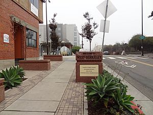
West Berkeley, Berkeley, California facts for kids
West Berkeley is a part of Berkeley, California. It is mostly the area west of San Pablo Avenue. Sometimes, it can also mean the larger area west of Sacramento Street, which includes Westbrae. West Berkeley is right next to San Francisco Bay.
This area includes a place once called Ocean View. It also has land that was filled in along the shoreline west of I-80. This filled-in land mainly includes the Berkeley Marina. West Berkeley is about 23 feet (7 meters) above sea level.
Contents
History of West Berkeley
The first people to live in this area were Native Americans. They settled near Strawberry Creek around 3700 BC. They built one of the biggest "shell mounds" around San Francisco Bay. A shell mound is a large pile of shells and other things left by ancient people. It might have been the very first of 425 such mounds.
Experts believe that native people lived near the West Berkeley Shellmound for 4,500 years. They left the shellmound around 800 AD. We do not know exactly where these people went. They might have joined other groups or moved away completely. The Ohlone tribe living today might be their descendants.
Ocean View: A Stagecoach Stop
Ocean View was the name of a stagecoach stop. A stagecoach stop was a place where horse-drawn coaches would stop. This stop was started by a former sea captain named William J. Bowen. It was on the Contra Costa Road, which is now San Pablo Avenue. This happened in the early 1850s.
The name "Ocean View" came from the amazing view of the Pacific Ocean. You could see it through the Golden Gate and across San Francisco Bay. This name was used for the small town that grew up there. It was between the stagecoach stop and a wharf built at the end of what is now Delaware Street.
Becoming West Berkeley
Ocean View became part of the new "Town of Berkeley" in 1878. After that, it was known as West Berkeley. The first mayor of Berkeley was Abel Whitton. He was from Ocean View and served from 1878 to 1881. For a short time (1908-1909), the area now called Albany, California, was also named Ocean View. This area is just north of Berkeley. Ocean View was mainly a place for factories and working-class families.
Saving Ocean View
The name "Ocean View" became popular again in the 1970s. This happened when neighbors fought against a city plan. The plan was called the West Berkeley Redevelopment Project. People wanted to save the old Victorian-style homes in the neighborhood. They formed a group called the Ocean View Committee (OVC).
The OVC worked with people who wanted to save old buildings. They also worked with state and national leaders. Together, they successfully saved Ocean View.
New Growth on 4th Street
After this, the area started to grow again. Many new apartments and shops were built. In the late 1970s, a shopping area grew along 4th Street. This led to changes in the homes nearby. More people with higher incomes moved in. This process is called gentrification.
Many popular stores are now on 4th Street. These include Anthropologie, Crate & Barrel Outlet, and Restoration Hardware. There are also places like Bette's Oceanview Diner and Peet's Coffee and Tea. You can also find Builder's Booksource, which sells books about architecture.
Since the 1970s, tours of West Berkeley have been offered. These tours show off the old buildings that have been fixed up.
Layout of West Berkeley
Delaware Street was once the main east-west road in Ocean View. Later, University Avenue became more important. The main north-south road was San Pablo Road. This road is now called San Pablo Avenue.
One of the first buildings in Berkeley was an inn called "Bowen's Inn." It was at the Ocean View stagecoach stop. Today, it would be at the northwest corner of San Pablo Avenue and Delaware Street.
Early Schools
The very first school in what is now Berkeley was the Ocean View School. It opened in 1856. It was on the southeast corner of Virginia Street and San Pablo Avenue. A creek flowed next to the school, so it was named "Schoolhouse Creek".
The school later changed its name to The San Pablo Avenue School. Then it became The Franklin Elementary School. None of the original Ocean View School building is left today. In 2002, Franklin Elementary School closed. It was turned into the Berkeley Adult School, which opened in 2004.
Aquatic Park
Just east of I-80, between Ashby and University Avenues, is Aquatic Park. This park was built in the 1930s by the WPA. The WPA was a government program that created jobs during the Great Depression. The main part of the park is a man-made lagoon. It is about a mile long.
Transportation in West Berkeley
The wharf at the end of Delaware Street was first called "Jacobs Landing." It was named after its builder, James H. Jacobs. The wharf was made bigger and better with help from Zimri Heywood. He owned a lumberyard at the wharf. So, it was renamed "Jacobs and Heywood Wharf."
Many goods were shipped from the wharf. These included lumber, soap, and hay. In 1874, a Ferry service started between the wharf and San Francisco.
Railroad and Train Service
In 1876, the Central Pacific Railroad built a new main train line. This line was part of the transcontinental overland route. It ran along the shoreline. A station for passengers and freight was built at Delaware Street. In 1911, a new station was built at 3rd Street and University Avenue.
Today, Amtrak's Berkeley Station is next to this old station. It offers train service every day.
Local Transit
Local public transportation in West Berkeley is provided by two services. These are Emery Go-Round and AC Transit.
 | Stephanie Wilson |
 | Charles Bolden |
 | Ronald McNair |
 | Frederick D. Gregory |


