West Burra facts for kids
| Norse name | Barrey |
|---|---|
| Meaning of name | west broch island? |
| OS grid reference | HU368324 |
| Coordinates | 60°04′N 1°22′W / 60.06°N 1.36°W |
| Physical geography | |
| Island group | Shetland |
| Area | 743 hectares (2.87 sq mi) |
| Area rank | 62 |
| Highest elevation | 65 metres (213 ft) |
| Administration | |
| Sovereign state | United Kingdom |
| Country | Scotland |
| Council area | Shetland Islands |
| Demographics | |
| Population | 776 |
| Population density | 104 people/km2 |
| Largest settlement | Hamnavoe |


West Burra is a lovely island in Scotland. It is part of the Shetland Islands group. West Burra is connected by a bridge to East Burra. It covers about 743 hectares (1,836 acres). This makes it the eleventh largest island in Shetland.
Contents
Exploring West Burra's Geography
West Burra has some cool places to explore. There is a sandy beach at Meal. It's a great spot on sunny days. At the island's south end, you will find Kettla Ness. This area has impressive cliffs. Kettla Ness is linked to the main island by a sandy strip of land. This strip is called a tombolo. It also has another nice beach.
At Duncansclett, there is a traditional thatched cottage. A local history group has restored it. This building was even shown on a BBC TV show called 'Restoration'. West Burra is connected to the Shetland Mainland. This connection is made by a series of bridges through another island called Trondra.
Main Settlements on West Burra
The biggest village on West Burra is Hamnavoe. This name is very common in Shetland. There is also a place called Bridge End. It got its name because it is close to the bridge that leads to East Burra.
West Burra's Interesting History
The name "Burra" might come from an old Norse word. Some people think it means "island of the broch". A broch is an ancient stone tower. Even though no broch is left, a place called Brough on West Burra supports this idea. However, in an old Viking story called the Orkneyinga saga, the island was called "Barrey".
The Papil Stone and Early Churches
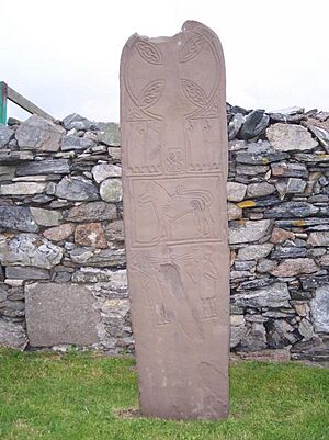
In the south of West Burra, there is a place called Papil. This name comes from the papar. These were early Christian monks. You can find similar names like Papyli in Iceland. This name suggests that an early church might have been there. We also have proof from the "Monk's Stone". This stone was found in Papil. It is now kept in the Shetland Museum.
Hamnavoe is the main village in northern West Burra. It is special because it was planned out. Landowners designed it, much like other villages in Scotland. A bigger example is Ullapool. Hamnavoe's original layout is still clear today.
Hamnavoe was once a very important fishing center. Today, you will not see big fishing boats there. But smaller boats still catch shellfish. Some people still fish full-time. However, fish farming is now a bigger part of the tradition. There are several mussel and salmon farms around Burra.
 | Leon Lynch |
 | Milton P. Webster |
 | Ferdinand Smith |

