West Hemlock Creek facts for kids
Quick facts for kids West Hemlock Creek |
|
|---|---|

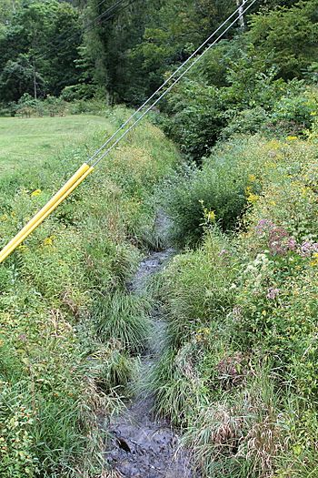
West Hemolock Creek near its mouth looking upstream
|
|
| Physical characteristics | |
| Main source | valley in eastern West Hemlock Township, Montour County, Pennsylvania |
| River mouth | Hemlock Creek in Hemlock Township, Columbia County, Pennsylvania 567 ft (173 m) 41°01′14″N 76°30′19″W / 41.02051°N 76.50534°W |
| Length | 3.7 mi (6.0 km) |
| Basin features | |
| Progression | Hemlock Creek → Fishing Creek → Susquehanna River → Chesapeake Bay |
| Basin size | 2.80 sq mi (7.3 km2) |
West Hemlock Creek is a small stream in Pennsylvania, USA. It flows through Montour County and Columbia County. The creek is about 3.7 miles (6.0 km) long. It eventually flows into Hemlock Creek. West Hemlock Creek has at least one smaller stream that flows into it. The creek and its smaller stream are affected by pollution. The area of land that drains into the creek is 2.80 square miles (7.3 km2). West Hemlock Creek is known as a coldwater fishery, which means its water is cold enough for certain fish.
Contents
The Journey of West Hemlock Creek
West Hemlock Creek starts in a valley in eastern West Hemlock Township. This is near a road called Hedge Road. The creek flows east for a short distance. Then it follows the border of the township for a while. After that, the creek turns southeast. It flows into Hemlock Township, Columbia County.
In Hemlock Township, the valley around West Hemlock Creek gets deeper. The creek keeps flowing southeast and then east for a few miles. It then leaves the valley. Soon after, it joins Hemlock Creek. This meeting point is near the community of Buckhorn. West Hemlock Creek joins Hemlock Creek about 3.02 miles (4.86 km) before Hemlock Creek reaches its own end.
Smaller Streams Joining the Creek
West Hemlock Creek has other smaller streams that flow into it. One of these is an unnamed stream known as UNT 65640353.
Water, Land, and Rocks Around the Creek
About 3.7 miles (6.0 km) of West Hemlock Creek is considered "impaired." This means its water quality is not as good as it should be. The main reason for this problem is siltation. Siltation happens when fine dirt and mud (silt) wash into the water. This silt comes from farming activities nearby. A smaller stream that flows into West Hemlock Creek is also affected. About 0.5 miles (0.80 km) of this unnamed stream has the same problem.
The elevation of West Hemlock Creek near where it joins Hemlock Creek is 567 feet (173 m) above sea level. The lower parts of the creek flow over rocks called the Trimmers Rock Formation. The upper parts of the creek are on rocks from the Irish Valley Member of the Catskill Formation. The creek is also close to a geological feature called the West Hemlock Creek Fault.
Most of the areas along West Hemlock Creek that could flood are not built up with houses or buildings. This helps protect them.
The Land Area Draining into the Creek
The entire area of land that drains water into West Hemlock Creek is called its watershed. This watershed covers about 2.80 square miles (7.3 km2). The land between the creek and Interstate 80 is covered in trees.
Plants and Animals Near the Creek
West Hemlock Creek is known as a coldwater fishery. This means its water stays cold enough for certain types of fish to live there. The sides of the valley around West Hemlock Creek have a special area called a riparian buffer. This buffer is mostly made up of eastern hemlock trees. These trees grow along the banks of the creek. There are also wet, forested areas called seeps near the creek. According to a local study, these areas might have "sensitive ecological features." This means they could be home to special or rare plants and animals.
 | Isaac Myers |
 | D. Hamilton Jackson |
 | A. Philip Randolph |

