West Point, Kentucky facts for kids
Quick facts for kids
West Point, Kentucky
|
|
|---|---|

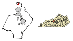
Location of West Point in Hardin County, Kentucky.
|
|
| Country | United States |
| State | Kentucky |
| County | Hardin |
| Area | |
| • Total | 2.69 sq mi (6.97 km2) |
| • Land | 2.67 sq mi (6.90 km2) |
| • Water | 0.03 sq mi (0.06 km2) |
| Elevation | 436 ft (133 m) |
| Population
(2020)
|
|
| • Total | 952 |
| • Density | 357.22/sq mi (137.93/km2) |
| Time zone | UTC-5 (Eastern (EST)) |
| • Summer (DST) | UTC-4 (EDT) |
| ZIP code |
40177
|
| Area code(s) | 502 |
| FIPS code | 21-81930 |
| GNIS feature ID | 0506467 |
West Point is a small city in Hardin County, Kentucky, United States. It is located near the Fort Knox military base and the Ohio River. In 2020, about 952 people lived in West Point. The city is part of the larger Elizabethtown–Fort Knox region.
Contents
History of West Point
Early Days and Famous Visitors
West Point was started by a pioneer named James Young. He built a cabin here in 1789. Later, in 1797, he built a brick house and an inn. This historic building is still standing today.
In 1803, the famous explorers Lewis and Clark traveled near West Point. They even asked a local person, John Shields, to join their important journey of discovery.
West Point During the Civil War
West Point is located where the Ohio River and Salt River meet. This was a very important spot during the American Civil War. The Union Army built a fort here to protect their supply routes.
This fort, called Fort Duffield, is the biggest and best-preserved earthen fort from that time in Kentucky. It's a great place to visit and learn about history.
Historic Places and Preservation Efforts
Many old buildings and places in West Point are still standing. A large part of the town is even listed as a historic district. This means it is protected for its historical importance.
One special project in West Point is restoring the West Point Independent Colored School. This school was built in 1926. It was one of the "Rosenwald Schools" that helped educate African-American children in rural areas. The plan is to use this one-room school as a visitor center and a place for learning.
West Point celebrated the 200th anniversary of Lewis and Clark's visit with a festival. This event celebrated local history and brought many tourists to the town. Fort Duffield is also a popular place for visitors all year round. The city recently received money to create walking trails at the fort.
Geography of West Point
West Point is located at the northern end of Hardin County. It sits where the Ohio River and Salt River come together. The Dixie Highway (U.S. Routes 31W and 60) runs through the city. This highway leads northeast about 21 miles to Louisville. It also goes south about 23 miles to Elizabethtown. Elizabethtown is the main city in Hardin County.
Fort Duffield Park is in the southern part of West Point. The remains of the fort are on top of a hill. This hill rises about 300 feet above the downtown area. The city is also next to the northern part of Fort Knox.
The city of West Point has a total area of about 1.4 square kilometers (0.54 square miles). All of this area is land.
Population and People
| Historical population | |||
|---|---|---|---|
| Census | Pop. | %± | |
| 1870 | 206 | — | |
| 1880 | 441 | 114.1% | |
| 1900 | 489 | — | |
| 1910 | 782 | 59.9% | |
| 1920 | 724 | −7.4% | |
| 1930 | 697 | −3.7% | |
| 1940 | 992 | 42.3% | |
| 1950 | 1,669 | 68.2% | |
| 1960 | 1,957 | 17.3% | |
| 1970 | 1,741 | −11.0% | |
| 1980 | 1,339 | −23.1% | |
| 1990 | 1,216 | −9.2% | |
| 2000 | 1,100 | −9.5% | |
| 2010 | 797 | −27.5% | |
| 2020 | 952 | 19.4% | |
| U.S. Decennial Census | |||
In 2000, there were 1,100 people living in West Point. There were 439 households and 281 families. The population density was about 408 people per square mile.
Most of the people in West Point were White (98.09%). A small number were African American (0.64%), Native American (0.64%), or Asian (0.09%). About 0.82% of the population were Hispanic or Latino.
About 31.4% of households had children under 18 living with them. About 43.7% were married couples. The average household had 2.51 people. The average family had 3.09 people.
The median age in the city was 34 years old. About 26.2% of the population was under 18. About 12.5% were 65 or older.
Education in West Point
West Point used to have its own school district. It operated one school for students from kindergarten to 8th grade. High school students from West Point attended Elizabethtown High School.
In 2020, the West Point Independent Schools Board decided to join with Hardin County Schools. This merger happened on July 1, 2020.
Now, kindergarten students go to North Park Elementary. Students in first through fifth grades attend Vine Grove Elementary. Sixth through eighth graders go to J.T. Alton Middle School. High school students from West Point now attend North Hardin High School.
See also
 In Spanish: West Point (Kentucky) para niños

