West Swanzey, New Hampshire facts for kids
Quick facts for kids
West Swanzey, New Hampshire
|
|
|---|---|

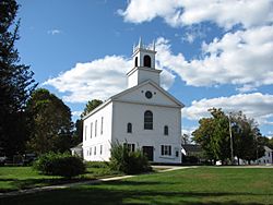
Baptist Church at the village center
|
|
| Country | United States |
| State | New Hampshire |
| County | Cheshire |
| Town | Swanzey |
| Area | |
| • Total | 2.60 sq mi (6.73 km2) |
| • Land | 2.58 sq mi (6.68 km2) |
| • Water | 0.02 sq mi (0.05 km2) |
| Elevation | 512 ft (156 m) |
| Population
(2020)
|
|
| • Total | 1,281 |
| • Density | 496.51/sq mi (191.69/km2) |
| Time zone | UTC-5 (Eastern (EST)) |
| • Summer (DST) | UTC-4 (EDT) |
| ZIP code |
03469
|
| Area code(s) | 603 |
| FIPS code | 33-83700 |
| GNIS feature ID | 0870797 |
West Swanzey is a small community located in the town of Swanzey, in Cheshire County, New Hampshire, United States. It's known as a census-designated place (CDP), which means it's a special area defined for collecting population information. In 2020, about 1,281 people lived there. West Swanzey is actually the biggest village within the larger town of Swanzey.
Contents
Exploring West Swanzey's Location
West Swanzey is found in the western part of the town of Swanzey. It sits on both sides of the Ashuelot River. This river is an important natural feature of the area.
Key Landmarks and Roads
A famous landmark in the village is the West Swanzey Covered Bridge. This historic bridge carries Main Street right over the Ashuelot River, making it a central part of the community.
New Hampshire Route 10 also runs through the western side of West Swanzey. This road connects the village to other nearby towns. For example, you can travel about 6 miles (10 km) north to reach Keene. If you head south, it's about 7 miles (11 km) to Winchester.
Size and Water Features
The West Swanzey CDP covers a total area of about 2.60 square miles (6.73 square kilometers). Most of this area, about 2.58 square miles (6.68 square kilometers), is land. A small part, about 0.02 square miles (0.05 square kilometers), is water, mainly from the Ashuelot River.
Who Lives in West Swanzey?
The population of West Swanzey has changed over the years. Here's a quick look at how many people have lived there during different census counts:
| Historical population | |||
|---|---|---|---|
| Census | Pop. | %± | |
| 1980 | 1,022 | — | |
| 1990 | 1,055 | 3.2% | |
| 2000 | 1,118 | 6.0% | |
| 2010 | 1,308 | 17.0% | |
| 2020 | 1,281 | −2.1% | |
| U.S. Decennial Census | |||
Population Details from 2010
In 2010, there were 1,308 people living in West Swanzey. These people lived in 581 different homes, and 340 of these were family households.
Most of the people living in West Swanzey in 2010 were white (93.2%). There were also smaller groups of Asian (4.4%), African American (0.8%), and Native American (0.2%) residents. About 1.2% of the population identified as Hispanic or Latino.
Household and Age Information
About 29.1% of the homes in West Swanzey had children under 18 years old living in them. Many homes (39.4%) were made up of married couples. About 10.2% of homes had someone living alone who was 65 years old or older.
The average age of people in West Swanzey in 2010 was about 37.9 years. This means the population was a mix of younger and older residents. About 21.5% of the residents were under 18, while 14.6% were 65 or older.
See also
 In Spanish: West Swanzey para niños
 | Jewel Prestage |
 | Ella Baker |
 | Fannie Lou Hamer |


