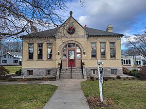
Westbrook Center, Connecticut facts for kids
Quick facts for kids
Westbrook Center, Connecticut
|
|
|---|---|

Westbrook Historical Society
|
|
| Country | |
| State | Connecticut |
| County | Middlesex |
| Town | Westbrook |
| Area | |
| • Total | 5.43 km2 (2.10 sq mi) |
| • Land | 4.37 km2 (1.69 sq mi) |
| • Water | 1.06 km2 (0.41 sq mi) |
| Elevation | 6 m (20 ft) |
| Population
(2010)
|
|
| • Total | 2,220 |
| • Density | 507.9/km2 (1,315/sq mi) |
| Time zone | UTC-5 (Eastern (EST)) |
| • Summer (DST) | UTC-4 (EDT) |
| ZIP Code |
06498 (Westbrook)
|
| Area code(s) | 860/959 |
| FIPS code | 09-81750 |
| GNIS feature ID | 2377878 |
Westbrook Center is a special area in the town of Westbrook, Middlesex County, Connecticut. It is called a census-designated place (CDP). This means it is a specific area that the government counts for population information. Westbrook Center includes the main village and nearby homes.
This community is located in the southern part of Westbrook. It is found along U.S. Route 1, a major road. To the south, it touches the Long Island Sound, which is a large body of water. The town of Old Saybrook is to its east. The Patchogue River forms its western and northwestern borders. In 2020, about 2,220 people lived in Westbrook Center. The whole town of Westbrook had 6,769 residents.
Exploring Westbrook Center's History
Westbrook Center has a special area called the Westbrook Town Center Historic District. This district covers about 178 acres (0.72 square kilometers). It is right in the middle of the community. This historic district helps protect old buildings and important places. It shows what the area looked like a long time ago.
See also
 In Spanish: Westbrook Center (Connecticut) para niños
 | Bayard Rustin |
 | Jeannette Carter |
 | Jeremiah A. Brown |


