Westbrook, Connecticut facts for kids
Quick facts for kids
Westbrook, Connecticut
|
||
|---|---|---|
| Town of Westbrook | ||
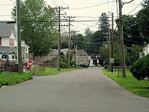
Looking east on Trolley Road
|
||
|
||
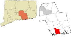
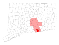 Middlesex County and Connecticut Middlesex County and Connecticut |
||
| Country | ||
| U.S. state | ||
| County | Middlesex | |
| Region | Lower CT River Valley | |
| Incorporated | 1840 | |
| Government | ||
| • Type | Selectman-town meeting | |
| Area | ||
| • Total | 21.4 sq mi (55.4 km2) | |
| • Land | 15.7 sq mi (40.7 km2) | |
| • Water | 5.7 sq mi (14.7 km2) | |
| Elevation | 52 ft (16 m) | |
| Population
(2020)
|
||
| • Total | 6,769 | |
| • Density | 431/sq mi (166.3/km2) | |
| Time zone | UTC−5 (Eastern) | |
| • Summer (DST) | UTC−4 (Eastern) | |
| ZIP code |
06498
|
|
| Area code(s) | 860/959 | |
| FIPS code | 09-81680 | |
| GNIS feature ID | 0213528 | |
| Website | http://www.westbrookct.us/ | |
Westbrook is a small and friendly town located in Middlesex County, Connecticut. It's part of the Lower Connecticut River Valley Planning Region. In 2020, about 6,769 people lived here. The main part of town, called the town center, is recognized as a special area by the U.S. Census Bureau.
Contents
Exploring Westbrook's Geography
Westbrook is found right on the shoreline of Connecticut. It shares its borders with other towns like Essex, Clinton, Deep River, and Old Saybrook. This is where the Connecticut River meets the Long Island Sound. A special place called the Salt Meadow Unit of the Stewart B. McKinney National Wildlife Refuge is also located in Westbrook.
Land and Water Areas
The town covers a total area of about 21.4 square miles (55.4 square kilometers). Most of this, about 15.7 square miles (40.7 square kilometers), is land. The rest, about 5.7 square miles (14.7 square kilometers), is water. The Westbrook Center area is smaller, with about 2.2 square miles (5.7 square kilometers), and a good portion of that is water too.
Islands and Beaches
Westbrook has three islands in the Long Island Sound. These islands are not lived on by people.
- Salt Island is the smallest, about 0.9 acres.
- Menunketesuck Island is the largest, about 4.6 acres. It's part of the Stewart B. McKinney National Wildlife Refuge.
- Duck Island is about 3.6 acres.
The town also has many private beach areas. Some of these include Chapman Beach, Coral Sands, Grove Beach Point, and Stannard Beach.
A Look at Westbrook's History
Westbrook became an official town in 1840. Before that, it had different names. It was first known as Pochoug. Later, it was called West Saybrook. At that time, it was a district within the larger Town of Old Saybrook.
Westbrook's Population Over Time
| Historical population | |||
|---|---|---|---|
| Census | Pop. | %± | |
| 1840 | 1,182 | — | |
| 1850 | 1,202 | 1.7% | |
| 1860 | 1,056 | −12.1% | |
| 1870 | 987 | −6.5% | |
| 1880 | 878 | −11.0% | |
| 1890 | 874 | −0.5% | |
| 1900 | 884 | 1.1% | |
| 1910 | 951 | 7.6% | |
| 1920 | 849 | −10.7% | |
| 1930 | 1,037 | 22.1% | |
| 1940 | 1,159 | 11.8% | |
| 1950 | 1,549 | 33.6% | |
| 1960 | 2,399 | 54.9% | |
| 1970 | 3,820 | 59.2% | |
| 1980 | 5,216 | 36.5% | |
| 1990 | 5,414 | 3.8% | |
| 2000 | 6,292 | 16.2% | |
| 2010 | 6,938 | 10.3% | |
| 2020 | 6,769 | −2.4% | |
| U.S. Decennial Census | |||
Over the years, Westbrook's population has changed. In 2000, there were 6,292 people living in the town. The average household had about 2.39 people. The average family had about 2.93 people.
Age Distribution in Westbrook
In 2000, about 21.8% of the people were under 18 years old. About 17.1% were 65 years or older. The median age in Westbrook was 42 years old. This means half the people were younger than 42 and half were older.
Education in Westbrook
Westbrook has its own public school district called Westbrook Public Schools. They make sure students get a good education.
Local Schools
- The public elementary school is Daisy Ingraham Elementary School. It even received a special award called the Blue Ribbon honor for excellence in 1998–1999.
- A new middle school opened in 2005. It is connected to the high school, Westbrook High School.
Specialty Schools
Oxford Academy is a special all-boys boarding school. It has been located in Westbrook since 1973.
Westbrook's Important Services
Westbrook has important services to keep everyone safe and connected.
Emergency Services
- The Connecticut State Police Troop F is located in Westbrook. Police services are managed by a Resident State Trooper and Police Constables.
- The Westbrook Fire Department provides fire protection. It's an all-volunteer department. They respond to fires, rescues, and medical emergencies.
- The Westbrook Ambulance Association provides emergency medical services. Paramedic services are also available from Middlesex Hospital.
Transportation Options
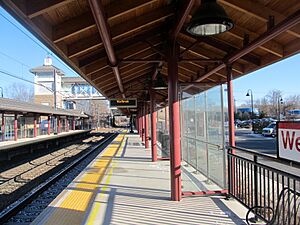
- Westbrook station is a stop on the Shore Line East commuter train line. This train helps people travel to and from work.
- The Estuary Transit District offers public bus transportation. This is called the 9 Town Transit Service. It connects Westbrook to nearby towns. You can also connect to the Old Saybrook Train Station. This station has Amtrak trains and the Shore Line East railroad.
Famous People from Westbrook
Westbrook has been home to some notable people:
- Everett Bacon (1890–1989): A famous athlete and a veteran of World War I. He was born in Westbrook.
- David Bushnell (1740–1824): An American inventor. He built the first submarine ever used in a battle.
- Art Carney (1918–2003): A well-known American actor and comedian.
- George Lessey (1879–1947): A silent movie actor. He lived his later years and passed away in Westbrook.
See also
 In Spanish: Westbrook (Connecticut) para niños
 | John T. Biggers |
 | Thomas Blackshear |
 | Mark Bradford |
 | Beverly Buchanan |


