Westcreek, Colorado facts for kids
Quick facts for kids
Westcreek, Colorado
|
|
|---|---|

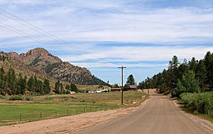
Westcreek Road in Westcreek.
|
|

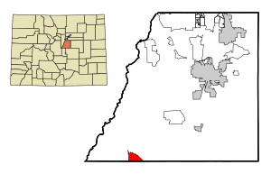
Location of the Westcreek CDP in Douglas County, Colorado.
|
|
| Country | |
| State | |
| County | Douglas County |
| Government | |
| • Type | unincorporated community |
| Area | |
| • Total | 1.260 sq mi (3.263 km2) |
| • Land | 1.218 sq mi (3.155 km2) |
| • Water | 0.042 sq mi (0.108 km2) |
| Elevation | 7,493 ft (2,284 m) |
| Population
(2020)
|
|
| • Total | 120 |
| • Density | 95/sq mi (36.8/km2) |
| Time zone | UTC-7 (MST) |
| • Summer (DST) | UTC-6 (MDT) |
| ZIP Code |
Sedalia 80135
|
| Area codes | 303 & 720 |
| GNIS feature | Westcreek CDP |
Westcreek is a small community located in Douglas County, Colorado, in the United States. It's known as an unincorporated community, which means it doesn't have its own local government like a city or town. Instead, it's managed by Douglas County.
Westcreek is also a census-designated place (CDP). This is a special area that the United States Census Bureau defines for counting people. It helps them gather information about how many people live in different parts of the country. Westcreek is part of the larger Denver–Aurora–Lakewood, CO Metropolitan Statistical Area. In 2020, about 120 people lived in Westcreek. The local post office that serves Westcreek is in Sedalia, Colorado, and its Zip Code is 80135.
Contents
Where is Westcreek Located?
Westcreek is found in the southwestern part of Douglas County. It sits in a valley, near a stream called West Creek. This stream flows north and eventually joins Horse Creek, which is part of the South Platte River system.
Colorado State Highway 67 goes right through Westcreek. If you travel north on this highway, you'll reach Deckers, Colorado, about 9 miles away. If you head southeast for about 15 miles, you'll arrive at Woodland Park, Colorado.
The total area of Westcreek is about 806 acres (3.263 km2). A small part of this area, about 27 acres (0.108 km2), is covered by water.
How Many People Live in Westcreek?
The United States Census Bureau first officially recognized Westcreek as a CDP for the United States Census 2000. They count the population every ten years.
Here's how the population of Westcreek has changed:
| Westcreek CDP, Colorado | ||
|---|---|---|
| Year | Pop. | ±% |
| 2000 | 105 | — |
| 2010 | 129 | +22.9% |
| 2020 | 120 | −7.0% |
| Source: United States Census Bureau | ||
Schools in Westcreek
Students living in Westcreek attend schools that are part of the Douglas County School District RE-1.
See also
 In Spanish: Westcreek para niños
 | Audre Lorde |
 | John Berry Meachum |
 | Ferdinand Lee Barnett |


