Westfir, Oregon facts for kids
Quick facts for kids
Westfir, Oregon
|
|
|---|---|

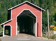
Office Covered Bridge, Westfir, Oregon
|
|

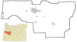
Location in Oregon
|
|
| Country | United States |
| State | Oregon |
| County | Lane |
| Incorporated | 1979 |
| Area | |
| • Total | 0.32 sq mi (0.82 km2) |
| • Land | 0.31 sq mi (0.81 km2) |
| • Water | 0.00 sq mi (0.01 km2) |
| Elevation | 1,070 ft (330 m) |
| Population
(2020)
|
|
| • Total | 259 |
| • Density | 824.84/sq mi (318.71/km2) |
| Time zone | UTC-8 (Pacific) |
| • Summer (DST) | UTC-7 (Pacific) |
| ZIP code |
97492
|
| Area code(s) | 541 |
| FIPS code | 41-79950 |
| GNIS feature ID | 2412234 |
| Website | www.ci.westfir.or.us |
Westfir is a small city in Oregon, United States. It is found in Lane County. In 2020, about 259 people lived there. Westfir is located in the Willamette National Forest. It is about 40 miles (64 km) southeast of Eugene. It is also about 4 miles (6 km) west of Oakridge.
Contents
Westfir's Past: A City Built by Lumber
The name Westfir was first used in July 1923. It came from the Western Lumber Company. This company made lumber from Douglas-fir trees. They built Westfir as a "company town." This means the company owned most of the homes and businesses.
Early Days and Railroad Connections
A big customer for the lumber mill was the Southern Pacific Railroad. In the 1920s, the railroad was building a new line. This line went over Willamette Pass between Eugene and Klamath Falls. It passed right through Westfir. The Westfir post office opened in November 1923. By 1931, about 500 people lived in the town.
Changing Owners and Town Incorporation
The Western Lumber sawmill was sold a few times. In 1946, the Edward Hines Lumber Company bought it. Hines also built a plywood mill in Westfir in 1952. But in 1977, Hines closed the mills. They sold the whole town, including the water and sewer systems.
The new owners wanted the town's services to be public. So, in 1979, the people living in Westfir voted to become an official city. This is called "incorporating." The mill operations completely closed in 1984 after several fires.
The Office Covered Bridge
Oregon's longest covered bridge is in Westfir. It is called the Office Bridge. It was built in 1944. This bridge crossed the North Fork Middle Fork Willamette River. It connected the Westfir Lumber Company mill to its main office.
Westfir's Location and Weather
Westfir is a small city. It covers about 0.33 square miles (0.85 square kilometers) of land.
Westfir's Climate: Warm, Dry Summers
Westfir has a type of weather called a warm-summer Mediterranean climate. This means summers are warm but not too hot. They are also usually dry. The average monthly temperature never goes above 71.6 °F (22 °C).
People Living in Westfir
| Historical population | |||
|---|---|---|---|
| Census | Pop. | %± | |
| 1980 | 312 | — | |
| 1990 | 278 | −10.9% | |
| 2000 | 276 | −0.7% | |
| 2010 | 253 | −8.3% | |
| 2020 | 259 | 2.4% | |
| U.S. Decennial Census | |||
In 2010, there were 253 people living in Westfir. They lived in 114 households. Most of the people were White (92.1%). About 2% of the population was Hispanic or Latino. The average age of people in Westfir was 51.1 years old.
Jobs and Businesses in Westfir
The biggest employers in the Westfir area are:
- The Oakridge School District
- Armstrong Wood Products
- Oakridge Sand & Gravel
Learning in Westfir
Students in Westfir go to schools in the Oakridge School District. This district has an elementary school, a middle school, and a high school in Oakridge. Westfir Middle School closed in 2006. The Westfir school district joined with the Oakridge school district in 1967.
Local News
The Dead Mountain Echo was a weekly newspaper. It was published in Oakridge and also served the Westfir community. It stopped publishing in 2020.
See also
 In Spanish: Westfir para niños
 | Valerie Thomas |
 | Frederick McKinley Jones |
 | George Edward Alcorn Jr. |
 | Thomas Mensah |


