
Westmere, New York facts for kids
Quick facts for kids
Westmere
|
|
|---|---|
 |
|

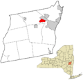
Location in Albany County and the state of New York.
|
|
| Country | United States |
| State | New York |
| Region | Capital District |
| County | Albany |
| Settled | 1920s |
| Area | |
| • Total | 3.18 sq mi (8.23 km2) |
| • Land | 3.17 sq mi (8.21 km2) |
| • Water | 0.01 sq mi (0.03 km2) |
| Elevation | 292 ft (89 m) |
| Population
(2020)
|
|
| • Total | 7,560 |
| • Density | 2,385.61/sq mi (921.03/km2) |
| Time zone | UTC-5 (EST) |
| • Summer (DST) | UTC-4 (EDT) |
| ZIP Code |
12203, 12084, 12159
|
| Area code(s) | 518 |
| FIPS code | 36-80423 |
| GNIS feature ID | 0970925 |
Westmere is a small community called a hamlet. It is located in the town of Guilderland, in Albany County, New York, United States.
The U.S. Census Bureau defines Westmere as a "census-designated place" (CDP). This means it has specific borders for counting its population. In 2020, about 7,560 people lived here. Westmere is a suburb of the nearby city of Albany.
U.S. Route 20, also known as Western Avenue, is the main road that cuts through the community. Along Western Avenue, you'll find many shops and businesses. Homes are mostly on the smaller streets to the north and south. Crossgates Mall, the biggest shopping mall in the Capital District area, is in Westmere.
Contents
History of Westmere
Westmere is a fairly new community. However, it sits along the Great Western Turnpike, a major road built in 1799. This road was a busy path for travelers moving from Albany and New England to the western parts of the country.
A "toll gate" once stood on the turnpike. This was a place where people paid a fee to use the road. Even before the turnpike was built, many wagons and sleighs passed through this area. For example, in 1796, about 300 wagons traveled through what would become Westmere.
After World War I, more homes started to appear in this rural, wooded area. These were often small bungalows and cottages. This growth sped up after World War II. The name Westmere was given to the area in the 1940s. During this time, Westmere was the fastest-growing part of the town of Guilderland.
Geography of Westmere
The exact borders of Westmere as a hamlet are not always clear. However, as a census-designated place (CDP), its borders are carefully defined.
Where is Westmere?
 |
City of Albany Pine Bush Preserve |
|
||
| Hamlet of Guilderland | Hamlet of McKownville | |||
| Town of New Scotland |
The city of Albany is to the north. New York Route 155 (State Farm Road/New Karner Road) forms the western border. The southern border follows Doctor Shaw Road, then Veeder Road, and Johnston Road. It then turns onto Church Road to U.S. Route 20 (Western Avenue). The border then goes along Western Avenue to the Governor Thomas E. Dewey Thruway (Interstate 87), and then north to the Albany city line. These borders can change slightly with each new census.
In 2000, the CDP had a total area of about 8.2 square kilometers (3.2 square miles). All of this area is land.
People of Westmere
| Westmere CDP Historical Populations | ||
|---|---|---|
| Year | Pop. | ±% |
| 1970 | 6,364 | — |
| 1980 | 6,881 | +8.1% |
| 1990 | 6,750 | −1.9% |
| 2000 | 7,188 | +6.5% |
| 2010 | 7,284 | +1.3% |
| 2020 | 7,560 | +3.8% |
| Source: U.S. Decennial Census | ||
In 2000, there were 7,188 people living in Westmere. There were 3,162 households, which are groups of people living together in one home. About 1,903 of these were families. The population density was about 2,260 people per square mile (873 people per square kilometer).
Most of the people in Westmere were White (88.75%). There were also African American (3.62%), Asian (6.25%), and other groups. About 2% of the population was Hispanic or Latino.
About 26.6% of households had children under 18 living with them. Nearly half (48.1%) were married couples. About 10.3% of households had someone aged 65 or older living alone. The average household had 2.25 people. The average family had 2.90 people.
The population was spread out by age. About 21.1% were under 18. About 15.7% were 65 or older. The average age was 40 years old.
The median income for a household in Westmere was $55,000. For families, it was $61,827. The average income per person was $28,790. A small number of families (3.0%) and people (4.1%) lived below the poverty line.
Fire Protection
The Westmere Fire Department started on December 31, 1935. Its job is to protect the people living in the community. In 1937, the state of New York officially recognized the Westmere Fire District.
Today, the Westmere Fire Department is still made up entirely of volunteers. More than 50 active firefighters give their time. It is the busiest fire department in the Town of Guilderland. The department uses three fire engines, a tower-ladder truck, a heavy-rescue truck, a multi-purpose pickup truck, and two command vehicles.
Images for kids
-
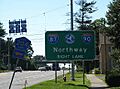
A view of Westmere, New York.
-
Map showing Westmere in Albany County, New York.
See also
 In Spanish: Westmere (Nueva York) para niños
