Westminster (village), Vermont facts for kids
Quick facts for kids
Westminster, Vermont
|
|
|---|---|
|
Village
|
|

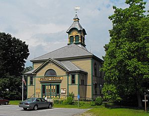
Westminster Town Hall
|
|
| Country | United States |
| State | Vermont |
| County | Windham |
| Area | |
| • Total | 1.37 sq mi (3.55 km2) |
| • Land | 1.36 sq mi (3.53 km2) |
| • Water | 0.01 sq mi (0.01 km2) |
| Elevation | 302 ft (92 m) |
| Population
(2020)
|
|
| • Total | 287 |
| • Density | 209.5/sq mi (80.85/km2) |
| Time zone | UTC-5 (Eastern (EST)) |
| • Summer (DST) | UTC-4 (EDT) |
| ZIP code |
05158
|
| Area code(s) | 802 |
| FIPS code | 50-81325 |
| GNIS feature ID | 1460185 |
|
Westminster Village Historic District
|
|
| Location | Main and School Sts., and Grout Ave., Westminster, Vermont |
| Area | 150 acres (61 ha) |
| Architect | Multiple |
| Architectural style | Mid 19th Century Revival, Late 19th And 20th Century Revivals, Late Victorian |
| NRHP reference No. | 88001058 |
| Added to NRHP | July 14, 1988 |
Westminster is a small village located in Windham County, Vermont, in the United States. In 2020, about 287 people lived here. Most of the village is recognized as a special historic area. It was added to the National Register of Historic Places in 1988. This area is known as the Westminster Village Historic District.
Contents
Geography of Westminster Village
Westminster village covers about 1.3 square miles. All of this area is land. The village is mainly found where U.S. Route 5 meets School Street and Grout Street. It stretches mostly along Route 5. The village's western edge is near Metcalf Drive and Cox Street. Its eastern edge is marked by an old cemetery. On School Street, the historic area goes north towards Thompson Road.
History of Westminster Village
Westminster is in the southeastern part of Vermont. It was the first town in Vermont to be officially set up. This happened in 1736 by the Province of Massachusetts Bay. The village center was planned between 1736 and 1737. The original plan included a very wide Main Street, which is now U.S. Route 5.
Early Charters and Disputes
The basic layout of the village today still shows parts of this early plan. The main road is still wide, even though its width was reduced in 1781. Public buildings like the town hall are built on old foundations. For example, the town hall stands where an 18th-century meeting house once was.
Westminster was in an area that different colonial governments wanted to control. Because of this, it received a second official document from the Province of New Hampshire in 1740. However, this document was later canceled. In 1764, the King decided that the Vermont area belonged to the Province of New York.
Road to Vermont's Independence
This disagreement over land led to Vermont becoming its own state. There was a sad event called the Westminster massacre on March 13, 1775. During this time, two men were hurt in a conflict. This happened between people who supported New York's claim and those who did not. This event was important in leading to the creation of the Vermont Republic in 1777. Vermont later joined the United States as a separate state in 1793. Westminster was one of the places where the republic's government met. It also served as a county seat until 1787.
Population of Westminster Village
| Historical population | |||
|---|---|---|---|
| Census | Pop. | %± | |
| 1920 | 313 | — | |
| 1930 | 320 | 2.2% | |
| 1940 | 270 | −15.6% | |
| 1950 | 298 | 10.4% | |
| 1960 | 333 | 11.7% | |
| 1970 | 446 | 33.9% | |
| 1980 | 319 | −28.5% | |
| 1990 | 399 | 25.1% | |
| 2000 | 276 | −30.8% | |
| 2010 | 291 | 5.4% | |
| 2020 | 287 | −1.4% | |
| U.S. Decennial Census | |||
In 2000, there were 276 people living in the village. These people lived in 118 households. About 78 of these were families. The village had about 209 people per square mile. All the people living in the village were White.
About 28% of households had children under 18 living with them. More than half, 57.6%, were married couples. About 7.6% of households had a female head with no husband. About 33.1% were not families. Many households, 25.4%, were made up of single individuals. About 10.2% had someone living alone who was 65 or older. On average, there were 2.34 people in each household. The average family size was 2.85 people.
The population was spread out by age. About 20.3% were under 18. About 9.4% were between 18 and 24. People aged 45 to 64 made up 33.3% of the population. The median age in the village was 44 years old. For every 100 females, there were about 84 males.
See also
 In Spanish: Westminster (condado de Windham, Vermont) para niños
 | Emma Amos |
 | Edward Mitchell Bannister |
 | Larry D. Alexander |
 | Ernie Barnes |


