
Weymouth Back River facts for kids
Quick facts for kids Weymouth Back River |
|
|---|---|

Looking southeast from David's Island at Weymouth Back River Bridge (Route 3A.
|
|
| Country | United States |
| State | Massachusetts |
| Cities | Weymouth, Hingham |
| Physical characteristics | |
| Main source | Whitman's Pond East Weymouth, Massachusetts, United States 20.5 ft (6.2 m) 42°12′45″N 70°55′40″W / 42.21250°N 70.92778°W |
| River mouth | Hingham Bay Weymouth, Massachusetts, United States 0 ft (0 m) 42°15′52″N 70°55′1″W / 42.26444°N 70.91694°W |
| Basin features | |
| Tributaries |
|
The Weymouth Back River is a short river in Hingham and Weymouth, Massachusetts. It's about 10 miles (16 km) south of Boston. This river is mostly a tidal river, meaning its water level changes with the ocean tides.
It starts from smaller streams and ponds, especially Whitmans Pond. The river flows north and then empties into Hingham Bay. This bay is near Grape Island and Slate Island.
Contents
River History
The Weymouth Back River formed about 12,000 years ago. This happened when the last glacier melted in New England. The melting ice caused sea levels to rise and flooded low-lying coastal areas.
The river's herring runs were a very important food source. Both the native people and early European settlers used them. The river has also been a boundary between Hingham and Weymouth since 1635.
Different businesses have used the river over time. These included a steel mill, a wool factory, and a fertilizer factory. The Army Corps of Engineers worked on the river in 1912 and 1943. They made the river channel deeper and wider for boats.
River System and Watershed
The Weymouth Back River gets its water from several places. Mill River and Old Swamp River both flow into Whitmans Pond. Whitmans Pond is where the Weymouth Back River officially begins.
After the Weymouth Back River becomes a tidal river, it gets more water. The Fresh River joins it from the right side as you head downstream.
River Ecology
The Weymouth Back River is part of a special area. It's called the Weymouth Back River Area of Critical Environmental Concern. This area covers about 950 acres (3.8 km²). About 180 acres (0.73 km²) of this are tidal waters.
The river's salt marshes are home to about 150 kinds of birds. The river is also surrounded by wooded areas that protect wildlife.
Fish Life and Spawning
A large number of herring used to swim up the river. These fish were a key food source for the people of Weymouth. Town records from 1648 mention this important fish run.
At Iron Hill Park, Whitmans Pond was dammed. This dam helped power machines for the Weymouth Iron Works. Later, a special "herring ladder" was built. This ladder helps herring swim past the dam to lay their eggs.
River herring usually refers to two types of fish. These are the Blueback herring and the alewife. Today, about half a million river herring and Rainbow smelt swim up the river each year. They come to lay their eggs, but they can only use the tidal parts of the river.
Osprey and Other Birds
Several nesting platforms have been built for Osprey. Osprey are also known as fish hawks. They have white undersides and a wingspan of 5 to 6 feet (152 to 183 cm).
Osprey mostly eat live fish like flounder, herring, and perch. You can often see them hovering over the water. They then dive feet first to catch their prey.
River Recreation
The Weymouth Back River is a great place for canoeing and kayaking. It's a popular spot in the Greater Boston area. The harbormasters from Hingham and Weymouth have made the river a "no-wake zone." This means boats must go slowly. Water-skiing and personal watercraft are not allowed south of the Route 3A Bridge.
Many parks and natural areas are along the river's banks. These include Abigail Adams Park, Stodder's Neck, Great Esker Park (in Weymouth), and Bare Cove Park (in Hingham).
Bicycling and hiking are also popular activities. The Back River Trail runs along both sides of the river. This trail connects many interesting environmental and historical spots.
Images for kids
-

Looking upstream from Great Esker Park, the esker is the tree-covered ridge on the right.
-
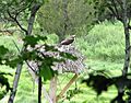
An Osprey in its nest on a special platform in Beal's Cove.
-
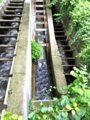
A double switchback fish ladder helps herring swim up the river to Whitmans Pond.
-
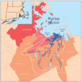
Map showing the Weymouth river area.
-
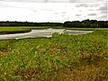
The upper tidal marsh of Weymouth Back River, seen from Great Esker Park.
_end_July_2012.jpg)


